
Shimoga, officially known as Shivamogga, is a city and the district headquarters of Shimoga district in the central part of the state of Karnataka, India. The city lies on the banks of the Tunga River. Being the gateway for the hilly region of the Western Ghats, the city is popularly nicknamed as "Gateway of Malnad". The population of Shimoga city is 322,650 as per 2011 census. The city has been selected for the Smart Cities project, standing in the fourth position in the state and 25th in the country as of November 2020.
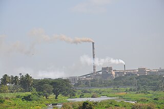
Bhadravati or Bhadravathi is an industrial city or Steel Town and taluk in the Shivamogga District of Karnataka state, India. It is situated at a distance of about 255 kilometres (158 mi) from the state capital Bengaluru and at about 20 kilometres (12 mi) from the district headquarters, Shivamogga. The town is spread over an area of 67.0536 square kilometres (25.8895 sq mi) and has a population of 151,102 as per the census held in 2011.

Shimoga district, officially known as Shivamogga district, is a district in the Karnataka state of India. A major part of Shimoga district lies in the Malnad region or the Sahyadri. Shimoga city is its administrative centre. Jog Falls view point is a major tourist attraction. As of 2011 Shimoga district has a population of 1,752,753. There are seven taluks: Soraba, Sagara, Hosanagar, Shimoga, Shikaripura, Thirthahalli, and Bhadravathi. Channagiri and Honnali were part of Shimoga district until 1997 when they became part of the newly formed Davanagere district.
Belaguthi is a village in the southern state of Karnataka, India. It is located in the Honnali taluk of Davanagere district.

Anavatti is a village in the southern state of Karnataka, India. It is located in the Soraba Taluk of Shivamogga district in Karnataka.
Arebilachi is a village in the southern state of Karnataka, India. It is located in the Bhadravati taluk of Shimoga district in Karnataka.The village has a PHC which is one of the largest in the state covering for a population of 20,000 people of all surrounding villages.
Donabaghatta is a village in the southern state of Karnataka, India. It is located in the Bhadravati taluk of Shimoga district in Karnataka.
Singanamane is a village in the southern state of Karnataka, India. It is located in the Bhadravati taluk of Shimoga district in Karnataka.
Adagadi is a village in the southern state of Karnataka, India. It is located in the Shimoga taluk of Shimoga district in Karnataka.
Adaranthe is a village in the southern state of Karnataka, India. It is located in the Sagara taluka of Shimoga district in Karnataka.
Adavalli is a village in the southern state of Karnataka, India. It is located in the Hosanagara taluk of Shimoga district in Karnataka.
Adrihalli is a village in the southern state of Karnataka, India. It is located in the Bhadravati taluk of Shimoga district in Karnataka.
Adur is a village in the southern state of Karnataka, India. It is located in the Sagara taluka of Shimoga district in Karnataka.
Agalabagilu is a village in the southern state of Karnataka, India. It is located in the Tirthahalli taluk of Shimoga district in Karnataka.
Agasanahalli is a village in the southern state of Karnataka, India. It is located in the Sorab taluk of Shimoga district in Karnataka.
Agasavalli is a village in the southern state of Karnataka, India. It is located in the Shimoga taluk of Shimoga district in Karnataka.

Aklapura is a village in the southern state of Karnataka, India. It is located in the Tirthahalli taluk of Shimoga district in Karnataka.
Alada Halli, Shivamogga is a village in the southern state of Karnataka, India. It is located in the Shivamogga taluk of Shimoga district in Karnataka. It is 12 KM away Shivamogga town.
Shivamogga Airport is a greenfield airport to be built at Sogane Village, 8.8 km (5.5 mi) from Shivamogga and 8.2 km (5.1 mi) from Bhadravathi in Karnataka, India. The airport was to be built under Public–private partnership (PPP) with the Government of Karnataka (GoK). However, due to delays in project execution, the contract was terminated in January 2015. On 15 June 2020, Karnataka chief minister B. S. Yediyurappa laid the foundation to start the construction of Shivamogga airport at the cost of The ₹220-crore. The chief minister said the airport, to be constructed in two phases, will be completed in about a year.

Hulikal is a village located in the Hosanagara taluk of the Shimoga district in the Indian state of Karnataka and is known for its heavy rainfall. The Hulikal village lies in western ghat region of Karnataka state. The range of ghat is known by the name Hulikal ghat or Balebare ghat. The road running between Hosangadi and Mastikatte through Hulikal ghati connects coastal district of Udupi with Shivamogga district. The Mani dam reservoir and Savehoklu reservoir are nearby. KPCL has its colony at Mastikatte near to Hulikal. The nearest airport is at Mangalore, situated 123 km south-west of Hulikal. It has an elevation of 600m.

