
Shimoga, officially known as Shivamogga, is a city and the district headquarters of Shimoga district in the central part of the state of Karnataka, India. The city lies on the banks of the Tunga River. Being the gateway for the hilly region of the Western Ghats, the city is popularly nicknamed as "Gateway to Malnad". The population of Shimoga city is 322,650 as per 2011 census.

Jog Falls is a waterfall on the Sharavati river located in the Western Ghats in Siddapur taluk Uttara Kannada District and having its view point in Sagara taluk, Shimoga district. It is the second highest plunge waterfall in India. It is a segmented waterfall which depends on rain and season becomes a plunge waterfall. The falls are major attractions for tourists and is ranked 13th in the world by the waterfall database.

Agumbe is a settlement situated in the Thirthahalli taluka of Shimoga district, Karnataka, India. It is nestled in the thickly forested Malenadu region of the Western Ghats mountain range. Owing to its high rainfall, it has received the epithet of "The Cherrapunji of South India", after Cherrapunji, one of the rainiest places in India.

Gokak is a taluka headquarters in the Belgaum District of Karnataka state, India. It is located around 70 km from Belgaum at the confluence of two rivers, the Ghataprabha and the Markandeya. The population of the town is according to 2011 census is approximately 135,773. The common language in use is Kannada.

Bhatkal, is a town in the Uttara Kannada District of the Indian state of Karnataka. Bhatkal lies on National Highway 66, which runs between Mumbai and Kanyakumari, and has one of the major railway stations along the Konkan Railway line, which runs between Mumbai and Mangalore. This place is sometimes referred to as Mini Dubai. This place is also known as "Al Nawayah".
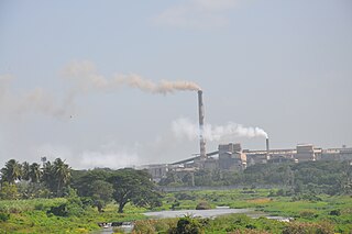
Bhadravati or Bhadravathi is an industrial city and taluk in the Shivamogga District of Karnataka state, India. It is situated at a distance of about 255 kilometres (158 mi) from the state capital Bengaluru and at about 20 kilometres (12 mi) from the district headquarters, Shivamogga. The town is spread over an area of 67.0536 square kilometres (25.8895 sq mi) and has a population of 151,102 as per the census held in 2011.

Kolluru or Kollur is a small temple-town in Byndoor Taluk in Udupi district of Karnataka state, India. It is situated about 27 km from Byndoor town. This village lies at the foot of the Western Ghats and is famous for the Mookambika temple, a Hindu pilgrim center. The village is located on the banks of Agnitheertha and Souparnika river.

Sirsi is a city and hilly region in Uttara Kannada District in Indian state of Karnataka. Sirsi was also known as Kalyanapattana during the Sonda Dynasty. Sirsi is also known as "Gate way of Malenadu" or "ಮಲೆನಾಡಿನ ಹೆಬ್ಬಾಗಿಲು" in Kannada or "Gateway of Western Ghats".

Shimoga district, officially known as Shivamogga district, is a district in the Karnataka state of India. A major part of Shimoga district lies in the Malnad region or the Sahyadri. Shimoga city is its administrative centre. Jog Falls is a major tourist attraction. As of 2011 Shimoga district has a population of 1,752,753. There are seven taluks: Soraba, Sagara, Hosanagar, Shimoga, Shikaripura, Thirthahalli, and Bhadravathi.

Chikkodi is a taluka and Town Municipal Council city in the Belgaum district of Karnataka, India. It is a Subdivision of the district. Chikodi, Athani, Hukkeri, Raybag, Nipani and Kagwad are the taluks that come under Chikodi Subdivision. It is 75 kilometers from the city of Belgaum, 65 kilometers from Kolhapur, 51 kilometers from Miraj, 160 kilometers from Hubballi, and 570 kilometers from the capital of Karnataka state, Bengaluru. Chikodi has many district level offices but it is not designated as a district by the Government of Karnataka. It is one of the major cities that lies in the border between Karnataka and Maharashtra states.
Hosanagar is a panchayat town in Shimoga district in the Indian state of Karnataka. It is nested in western ghats of India. The World Cattle Conference with main emphasis on cow was held in month of April 2007 in Hosanagar. The different uses of cow were exhibited. Near Hosanagar there is a mutt named Sri Ramachandrapura Math just 6 km from Hosanagar Town.
Tarikere is a Taluk in the Chikkamagaluru district in the state of Karnataka of India. The headquarters of the Tarikere are a town of the same name.Its popularly known as gateway of malnad because malnad area starts from here. The town's name is derived from the number of water tanks which surround it. Tarikere is also known as gateway of malnad or Malenadina Hebbagilu in kannada
Honnemaradu is a tourist place situated on the back waters of River Sharavathi in India. Honnemardu derived its name from the Honne tree. However, the literal meaning of Honnemardu is Golden Lake. This is perhaps a reference to the fact that Honnemardu is located on the backwaters of the Sharavathi river.

Badiyadka officially known as "Badiadka" is a town and gram panchayat in the Kasaragod district, state of Kerala, India.
Harana Halli is a village in the southern state of Karnataka, India. It is located in the Shimoga taluk of Shimoga district in Karnataka. Harana Halli is about 21 km from Shimoga town. The trains operating from Birur to Sagara go via Harana Halli railway station. The famous Shimoga-Talaguppa railway (RailBus) route which provides access to Jog Falls goes via Harana Halli. The Rail bus service is now stopped.
Adagalale is a village in the southern state of Karnataka, India. It is located in the Sagara taluka of Shimoga district in Karnataka. The people of Adagalale mainly depends on agriculture, the crops are paddy and Areca nut.
Charekone is a small village in Siddapura Taluk Uttara Kannada District, Karnataka State; Which is about 32 kilometres (20 mi) from Sirsi and 28 kilometres (17 mi) from Siddapur.
Kattinahole ಕಟ್ಟಿನಹೊಳೆ is a small village in Hosanagara Taluk, Shimoga District of the Indian state of Karnataka. The local language of Kattinahole is Kannada.
Hittalakoppa is one of the major villages of Siddapura taluk in Karwar District, India. It is 11km away from Siddapur and 25 km away from Sagar city and 77.68 km from the city of Shimoga, 216 km from port city Mangalore and 323 km from state capital Bangalore.
Sagara is a city located in the Indian state of Karnataka and it is also a sub divisional and a taluk headquarters. Located in the Western Ghats range, it is known for its proximity to Jog Falls and to the historical places of Ikkeri, Keladi and Varadamoola. The river Varada originates near Varada-moola. Sagara subdivision consists of Sagara, Soraba, Hosanagara and Shikaripur taluks.

