
The Krishna River in the Deccan plateau is the third-longest river in India, after the Ganga and Godavari. It is also the fourth-largest in terms of water inflows and river basin area in India, after the Ganges, Indus and Godavari. The river, also called Krishnaveni, is 1,400 kilometres (870 mi) long and its length in Maharashtra is 282 kilometres. It is a major source of irrigation in the Indian states of Maharashtra, Karnataka, Telangana and Andhra Pradesh.

Kurla is a suburb of East Mumbai, India. It is the headquarters of the Kurla taluka of Mumbai Suburban district. The neighbourhood is named after the eponymous East Indian village that it grew out of. It falls under Zone 5, Ward 'L' of the Bombay Municipal Corporation. Its railway station, spelt as Coorla until 1890, is one of the busiest on the Mumbai suburban railway on the central and harbour railway lines of Mumbai as is the Lokmanya Tilak Terminus (LTT) for out-station passenger/express trains.

The North Western Ghats moist deciduous forests is a tropical moist broadleaf forest ecoregion of southwestern India.

Domlur is a small township located in the eastern part of Bangalore city in India. Domlur was included in the erstwhile Bangalore Civil and Military Station under the British Madras Presidency till it was transferred to the Mysore State in 1949.

Basaveshwaranagara, also known as Basaveshwaranagar, Basaveshnagara or Basaveshnagar is a largely residential neighbourhood in the west of Bengaluru, Karnataka, India. It is located to the west of Rajajinagara and is sandwiched between the localities of Mahalakshmi Layout to the north and Vijayanagara to the south, spread across multiple sub-localities, three assembly constituencies and seven Bruhat Bengaluru Mahanagara Palike (BBMP) wards. The area of Basaveshwaranagara is often considered West of Chord Road as it lies to the west of Chord Road, an arterial road in the western part of Bengaluru.

Bruhat Bengaluru Mahanagara Palike (BBMP) is the administrative body responsible for civic amenities and some infrastructural assets of the Greater Bengaluru metropolitan area. It is the fourth largest Municipal Corporation in India and is responsible for a population of 8.4 million in an area of 741 km2. Its boundaries have expanded more than 10 times over the last six decades.

Peravoor is a town and Grama Panchayat in Kannur district of Kerala state in India. It is located 50 km (31 mi) east of Kannur and 40 km (25 mi) north east of Thalassery. And Iritty, the nearest municipality is 14 km (8.7 mi) north of Peravoor. Peravoor is situated in the Western Ghats mountain range.

Karnataka, the sixth largest state in India, has been ranked as the third most popular state in the country for tourism in 2014. It is home to 507 of the 3600 centrally protected monuments in India, second only to Uttar Pradesh. The State Directorate of Archaeology and Museums protects an additional 752 monuments and another 25,000 monuments are yet to receive protection.
Jalahalli is a suburb in northern part of Bengaluru is one of the greenest areas of Bengaluru. It is mainly divided into Jalahalli East and Jalahalli West. Gangamma Circle is the junction between the roads connecting Jalahalli East, Jalahalli West, Jalahalli Village, and Jalahalli Cross. The National Academy of Customs and Narcotics in Bengaluru is located here.
Basavana Bagewadi is a municipality and taluka in Bijapur district in the state of Karnataka, India.
Silokhra is a village located in Gurugram city in the Gurugram district of Haryana, India. The village has a population of approximately 7715 individuals residing in around 1831 households. Although there are various castes living in the village, Brahmins make up the most significant demographic.

Ramamurthy Nagar ( ) is an area in Bangalore in the Indian state of Karnataka. It is located in the eastern part of Bangalore and comes under the E3 subdivision of BBMP. It is a rapidly growing suburb, adjacent to other areas such as Banaswadi, CV Raman Nagar and Krishnarajapuram, also officially called Krishnarajapura.

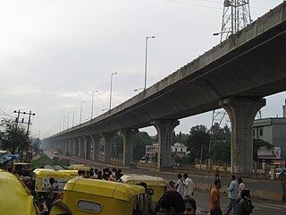
Dasarahalli is an elevated metro station on the North-South corridor of the Green Line of Namma Metro serving the Dasarahalli area of Bangalore, India. It was opened to the public on 1 May 2015.
Dollars Colony is an upmarket residential locality in Bangalore, India. It is situated towards the north of Bangalore Central Business District. It is located 874 meters above mean sea level.

Dasarahalli is a northwestern suburb of Bangalore in Bangalore Urban district in the state of Karnataka, India. The place is well known for its religious establishments such as Jalahalli Sree Ayyappan Temple, Shri Kari Maramma Devi Temple, Bagalgunte Maramma temple, Mallasandra Sri Prasanna Anjenya temple, Kaliyamma Temple, CSI Holy Cross Church, and St Dionysius Orthodox Church. Residential areas like Vaishnavi Rathnam, Casa Serene, Shantiniketan Apartments, Sobha ruby apartments, Ayyappa Nagar, Pipeline road, Grape Garden and Prashanth Nagar S.M road that includes the main Parayil Verghese family home. Police stations in the locality are Bagalgunte PS, Peenya PS and Gangammagudi PS. Nearby Hospitals are People tree Hospital, GJM Hospital, Prakriya Hospitals and Sree Ayyappan Temple Medical Center.

Yelahanka Ward, officially known as Kempegowda Ward is one of the 225 Wards of Bruhat Bengaluru Mahanagara Palike, an administrative body responsible for civic amenities and some infrastructural assets of the Greater Bangalore metropolitan area in the Indian state of Karnataka.
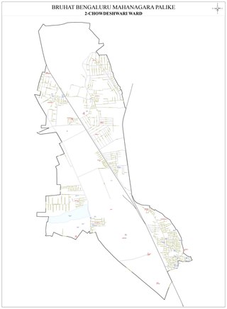
Chowdeshwari Ward, is one of the 198 Wards of Bruhat Bengaluru Mahanagara Palike, an administrative body responsible for civic amenities and some infrastructural assets of the Greater Bangalore metropolitan area in the Indian state of Karnataka.

Attur Ward, is one of the 198 Wards of Bruhat Bengaluru Mahanagara Palike, an administrative body responsible for civic amenities and some infrastructural assets of the Greater Bangalore metropolitan area in the Indian state of Karnataka.
Shettihalli Wildlife Sanctuary is a wildlife sanctuary in the state of Karnataka, India. It was declared a wildlife sanctuary on 23 November 1974.