
Pinal County is a county in the central part of the U.S. state of Arizona. According to the 2020 census, the population of the county was 425,264, making it Arizona's third-most populous county. The county seat is Florence. The county was established in 1875.

Gifu Prefecture is a prefecture of Japan located in the Chūbu region of Honshu. Gifu Prefecture has a population of 1,991,390 and has a geographic area of 10,621 square kilometres (4,101 sq mi). Gifu Prefecture borders Toyama Prefecture to the north; Ishikawa Prefecture to the northwest, Fukui Prefecture and Shiga Prefecture to the west, Mie Prefecture to the southwest, Aichi Prefecture to the south, and Nagano Prefecture to the east.

Plymouth is a town and county seat of Plymouth County, Massachusetts, United States. Located in Greater Boston, the town holds a place of great prominence in American history, folklore, and culture, and is known as "America's Hometown". Plymouth was the site of the colony founded in 1620 by the Mayflower Pilgrims, where New England was first established. It is the oldest municipality in New England and one of the oldest in the United States. The town has served as the location of several prominent events, one of the more notable being the First Thanksgiving feast. Plymouth served as the capital of Plymouth Colony from its founding in 1620 until the colony's merger with the Massachusetts Bay Colony in 1691. The English explorer John Smith named the area Plymouth and the region 'New England' during his voyage of 1614. It was a later coincidence that, after an aborted attempt to make the 1620 trans-Atlantic crossing from Southampton, the Mayflower finally set sail for America from Plymouth, England.
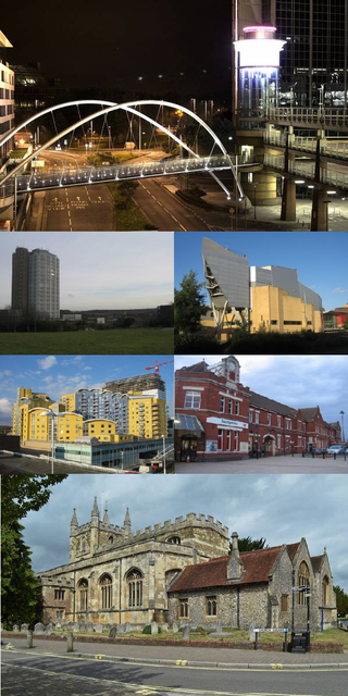
Basingstoke is a town in Hampshire, situated in south-central England across a valley at the source of the River Loddon on the western edge of the North Downs. It is the largest settlement in Hampshire without city status. It is located 30 miles (48 km) north-east of Southampton, 48 miles (77 km) south-west of London, 27 miles (43 km) west of Guildford, 22 miles (35 km) south of Reading and 20 miles (32 km) north-east of the county town and former capital Winchester. According to the 2016 population estimate, the town had a population of 113,776. It is part of the borough of Basingstoke and Deane and part of the parliamentary constituency of Basingstoke.
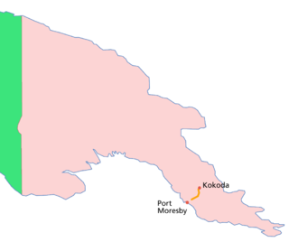
The Kokoda Track or Trail is a single-file foot thoroughfare that runs 96 kilometres (60 mi) overland – 60 kilometres (37 mi) in a straight line – through the Owen Stanley Range in Papua New Guinea (PNG). The track was the location of the 1942 World War II battle between Japanese and Allied – primarily Australian – forces in what was then the Australian territory of Papua.
Thornton is a village in the Borough of Wyre, about 4 miles (6 km) north of Blackpool and 2 miles (3 km) south of Fleetwood. The civil parish of Thornton became an urban district in 1900, and was renamed Thornton-Cleveleys in 1927. In 2011, the Thornton built-up area sub division had a population of 18,941.

The N17 road is a national primary road in Ireland, and is part of the Atlantic Corridor route. It begins in County Galway and ends in County Sligo. On 27 September 2017 the southern, Tuam–Galway, section was upgraded to motorway status and designated M17.

The N18 road is a national primary road in Ireland, connecting the cities of Limerick and Galway. Ennis and Gort are two major towns on the route, and Shannon Airport is reached via the connecting N19. The west coast route continues on to Sligo as the N17. The section from Limerick to the N19 junction forms part of European route E20, and the entire route is part of the proposed Atlantic Corridor. The section of motorway from Shannon to Claregalway is designated the M18 motorway. The tolled Limerick Tunnel forms part of the route.

The N59 road is a national secondary road in Ireland. It commences in County Sligo, south of Sligo Town at the Belladrehid interchange with the N4 north of Ballysadare. The route circles around the west of Ireland, passing west from Sligo into County Mayo and through Ballina. The N59 continues around Mayo, proceeding indirectly to Westport. Continuing south through Mayo into County Galway, the road passes through the village of Leenaun. The 182-year-old bridge in the centre of the village, carrying the road across the River Lahill, collapsed in floods on 18 July 2007. Due to the local terrain and road network, the diversionary route for getting from the south of the village to Westport was 110 km long. A temporary bridge was opened eight days after the floods, on 27 July. It has since been replaced by a new bridge.

Ballygowan is a village in County Down, Northern Ireland. It is within the Ards and North Down Borough. The town of Comber is a short distance to the north-east, the town of Saintfield to the south, and the city of Belfast further to the north-west. It is within the civil parishes of Killinchy and Comber and is split between the historic baronies of Castlereagh Lower and Castlereagh Upper. It had a population of 3,138 people in the 2021 Census.
Highway 1 is the Saskatchewan section of the Trans-Canada Highway mainland route. The total distance of the Trans-Canada Highway in Saskatchewan is 654 kilometres (406 mi). The highway traverses Saskatchewan from the western border with Alberta, from Highway 1, to the Manitoba border where it continues as PTH 1. The Trans-Canada Highway Act was passed on December 10, 1949. The Saskatchewan segment was completed August 21, 1957, and completely twinned on November 6, 2008. The speed limit along the majority of the route is 110 kilometres per hour (70 mph) with urban area thoroughfares slowing to a speed of 80–100 kilometres per hour (50–62 mph). Portions of the highway—the section through Swift Current, an 8-kilometre (5 mi) section east of Moose Jaw, and a 44-kilometre (27 mi) section between the West Regina Bypass and Balgonie—are controlled-access. Highway 1 serves as a major east–west transport route for commercial traffic. It is the main link between southern Saskatchewan's largest cities, and also serves as the province's main link to the neighbouring provinces of Alberta and Manitoba.

Arlington Transit (ART) is a bus transit system that operates in Arlington County, Virginia, and is managed by the county government. The bus system provides service within Arlington County, and connects to Metrobus, nearby Metrorail stations, Virginia Railway Express, and other local bus systems. Most ART routes serve to connect county neighborhoods to local Metrorail stations, as well as the Shirlington Bus Station. It includes part of the Pike Ride service along Columbia Pike, which is shared with WMATA. In 2023, the system had a ridership of 2,258,200, or about 8,400 per weekday as of the third quarter of 2024.

The A143 is a road that runs from the Gorleston-on-Sea area of Great Yarmouth, in Norfolk to Haverhill in Suffolk.

Chillerton is a village between Newport and Chale in the Isle of Wight in southern England. Chillerton is in the middle of a farming community. It is in the civil parish of Chillerton and Gatcombe, along with nearby Gatcombe; the parish had a total population of 422 at the 2011 census.

Bitton railway station is the main station of the Avon Valley Railway. It is located near the village of Bitton, South Gloucestershire.
Northwood is a village and civil parish on the Isle of Wight. It lies south of the town of Cowes and has been occupied for about 1000 years. The Church of St. John the Baptist in Northwood, was first built between the 11th and 13th centuries.

The R280 road is a regional road in Ireland linking Bundoran in County Donegal in the north to Carrick-on-Shannon in County Leitrim. En route it passes through Kinlough, Manorhamilton, Drumkeeran and Leitrim village. The road is 74 km (46 mi) long.

The M18 motorway is an inter-urban motorway in Ireland, forming part of the Limerick, Ennis to Galway national primary road, which, in turn, forms part of the Atlantic Corridor called for as part of the Transport 21 project.

East Village is an area in Stratford, East London that was designed and constructed as the Olympic Village of the 2012 Summer Olympics and has been converted for use as a new residential district, complete with independent shops, bars and restaurants. The area was formerly contaminated waste land and industrial buildings to the north of Stratford town centre. More than 7,000 people now live in the area.