Electronic City is an information technology hub in Bengaluru, India, located in Anekal taluk. Spread over 800 acres (3.2 km²) near Konappana Agrahara and Doddathogur it houses a large number of electronic/IT industrial parks.
The South Pennar River is a river in India. It is the second longest river in Tamil Nadu, with a length of 497 km, after the Kaveri. Chandapura, Anekal, Hosur, Bagalur and Chengam are the major industrial settlements on its banks. The river is severely polluted by industrial waste as it flows through major industrial areas in the eastern suburbs of Bangalore and the industrial parks of Hosur and Chengam.
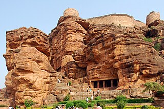
Badami, formerly known as Vātāpi, is a town and headquarters of a taluk by the same name, in the Bagalkot district of Karnataka, India. It was the regal capital of the Badami Chalukyas from 540 to 757. It is famous for its rock cut monuments such as the Badami cave temples, as well as the structural temples such as the Bhutanatha temples, Badami Shivalaya and Jambulingesvara Temple. It is located in a ravine at the foot of a rugged, red sandstone outcrop that surrounds Agastya lake.
Anekal (ಆನೇಕಲ್) is a major town and taluk of Bengaluru Urban district, part of the Bangalore Metropolitan Region. It is a major town in the suburbs of Bengaluru. The Chandapura-Anekal stretch is an emerging residential hub in Bengaluru. It is approximately 36 km from the centre of Bengaluru and around 15 km from Hosur and Electronic City. It lies in the southern part of the Bangalore metropolitan area. Anekal is known for the Karaga and Dasara festivals.
Kugur is a cultural heritage village in the Anekal taluk of Bangalore district in the Indian state of Karnataka. It is located near Sarjapura.
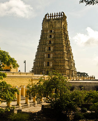
The Chamundeshwari Temple is a Hindu temple located on the top of Chamundi Hills about 13 km from the palace city of Mysuru in the state of Karnataka in India. The temple was named after Chamundeshwari or, the fierce form of Shakti, a tutelary deity held in reverence for centuries by the Maharaja of Mysuru.

Karnataka, the sixth largest state in India, has been ranked as the third most popular state in the country for tourism in 2014. It is home to 507 of the 3600 centrally protected monuments in India, second only to Uttar Pradesh. The State Directorate of Archaeology and Museums protects an additional 752 monuments and another 25,000 monuments are yet to receive protection.

Sharane Sri Danamma Devi is worshipped as an incarnation(avatar) of Goddess Parvati. Shri Shiva Sharani Danamma Devi was initially called "Lingamma". She was born in Anantaraya and Shirasamma in Maharashtra in a small city (grama) of "Umarani" in Jatta Taluk, 20 miles west of the Bijapur district. Jagajyoti Basavanna foretold her that she would be worshipped worldwide by the name "Danamma Sharani". From then on, Lingamma is popularly called and revered as Danamma. She started solving the problems of people in Kalyana.
Narayana Ghatta is a village in Anekal Taluk, Muthanallur panchayat, Sarjapura Hobli, Bangalore, India. The village has a population of around 2,500. and it is close to Electronic city

Nooranad is a developing town in Mavelikkara taluk of Alappuzha district in the Indian state of Kerala. It is located at a distance of 8 Km south-west of Pandalam, in Kayamkulam route. Padanilam is the cultural centre of Nooranad region. The Padanilam Parabrahma Temple, known for the biggest Shivarathri Kettukazhcha in Kerala, is situated in Nooranad. Nooranad is declared by the Government of Kerala as the Nandikesha Paithruka Gramam due to its importance in Kettukala making, which is an icon of Onattukara region of Central Travancore. Nooranad is also known as Pakshi Gramam of kerala.

Uppinangady or Ubar is a town in the Puttur talk of Dakshina Kannada district in the state of Karnataka, India. It is surrounded by the Kumaradhara River on one side and Nethravathi River on the other. When the town's two surrounding rivers rise during the rainy season and meet, this is called the "Sangam" which is a Sanskrit word for confluence. The Sangam is a major event as people from the surrounding villages crowd the river banks to witness the merge. The population of Uppinangady is 7,172.
Gandhinagar formerly known as Jalihal Camp, is one of the largest villages in Karnataka state in terms of area, population, property, agricultural production and revenue. It is the first government recognized revenue village in the Tunga Bhadra Delta Region. From 17 May 1997 onward, this village was renamed Gandhi Nagar from Jalihal Camp. is located on either sides of Tunga bhadra left Bank Canal,#36. In this village, there are many fertile, high-yielding paddy fields. Paddy is the main agricultural crop in the Tunga Bhadra Delta Region and the paddy varieties grown here include: Sonamasuri, Emergency, Ganga Kaveri, Nellore Sona, JJL, RS22.

Kadugodi is a suburb located in Whitefield, Bangalore in the state of Karnataka, India. The area is said to have been founded over 1000 years ago by the Chola dynasty.
Shri Kuruvathi Basaveshwara temple at Kuruvathi is one of the ancient and historic temples at the extreme south-western corner of Hoovina Hadagali taluk, Vijayanagara District, Karnataka, India. This temple is on the bank of Tungabhadra river, 10 km from Halavagalu and 2 km from Mylara and 36 km from Ranebennur and 326 km from Bangalore.
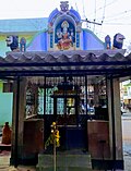
Neriga is a village in the Anekal taluk of Bangalore Urban district in the Indian state of Karnataka. It is located near Varthuru.
Patrame is a small, rural panchayat village on the left (east) bank of the Netravati River in Karnataka, India. Administratively, it is under Belthangady taluk, Dakshina Kannada district, Karnataka. Patrame is the only village in its gram panchayat. The village of Patrame is 26 km from its taluk headquarters Belthangady, and 8 km by road from Dharmasthala.

Sirsi Marikamba Temple is a Hindu temple dedicated to Marikamba Devi, located in Sirsi, Karnataka, It is also known as Marigudi, It was built in 1688, Sirsi Shri Marikamba Devi is "elder sister" of all Marikamba Devi's in Karnataka.

Ramamurthy Nagar ( ) is an area in Bangalore in the Indian state of Karnataka. It is located in the eastern part of Bangalore and comes under the E3 subdivision of BBMP. It is a rapidly growing suburb, adjacent to other areas such as Banaswadi, CV Raman Nagar and Krishnarajapuram, also officially called Krishnarajapura.

Thindlu, once an ancient village, is now a part of the Bangalore North. Thindlu is famous for its ancient temple of lord Virabhadra and is currently a thriving community with many real estate constructions. Thindlu comes under Vidyaranyapura ward of Byatarayanapura constituency. Byatarayanapura is one of the largest constituency of Bangalore. Many residential layouts have recently come up. Thindlu is located to the east of Vidyaranyapura and to the west of Sahakara Nagar. Once a rural village, it has now become very well integrated to Bengaluru city style. With many new residential apartments and with the influx of people this area does not resemble anymore like an rural village, although some areas still retain Village type old houses. Although declining, Animal husbandry can still be witnessed here like any other part of Bangalore Rural district.

Munjenahalli (Manjenahalli) is a small village in Arsikere taluk, Hassan district, in the Indian state of Karnataka. The village has population of 487 of which 238 are males and 249 are females as per Population Census 2011.