
Karnataka is a state in the southwestern region of India. It was formed as Mysore State on 1 November 1956, with the passage of the States Reorganisation Act, and renamed Karnataka in 1973. The state is bordered by the Lakshadweep Sea to the west, Goa to the northwest, Maharashtra to the north, Telangana to the northeast, Andhra Pradesh to the east, Tamil Nadu to the southeast, and Kerala to the southwest. With 61,130,704 inhabitants at the 2011 census, Karnataka is the eighth-largest state by population, comprising 31 districts. With 15,257,000 residents, the state capital Bengaluru is the largest city of Karnataka.

Kalaburagi, formerly known as Gulbarga, is a city in the Indian state of Karnataka, It is headquarters of eponymous Kalaburagi district and Kalaburagi division, Kalaburagi city is governed by a Municipal Corporation, It is called a Sufi city. It has famous religious structures, like the Hazrath Khwaja Banda Nawaz Dargah, the Sharana Basaveshwara Temple and the Buddha Vihar. It also has a fort built during the Bahmani rule, Other Bahmani monuments include the Haft Gumbaz and the Shor Gumbad. Kalaburagi has the world's largest cannon, Kalaburagi has a few architectural marvels built during the Bahamani Kingdom rule, including the Jama Masjid in the Kalaburagi Fort. Kalaburagi houses the circuit bench of the High Court of Karnataka. Under the name Monuments and Forts of the Deccan Sultanate, Several buildings in the city and with others in the region were put by UNESCO on its "tentative list" of World Heritage Site in 2014.

Davanagere is a city in the centre of the southern Indian state of Karnataka. It is the seventh largest city in the state, and the administrative headquarters of eponymous Davangere district. Hitherto being a cotton hub and hence popularly known before as the Manchester of Karnataka, the commercial ventures of the city is now dominated by education and agro-processing industries. Davanagere became a separate district in 1997, when it was separated from the erstwhile undivided district of Chitradurga for administration conveniences. Davanagere is known for rich culinary traditions which encompass the diversity of entire Karnataka's dishes due to its geographical position in the state as its centre. Notable among them is its aromatic benne dose.
Bengaluru Urban district is the most densely populated of the thirty-one districts that comprise the Indian state of Karnataka. It is surrounded by the Bangalore Rural district on the east and north, the Ramanagara district on the west and the Krishnagiri district of Tamil Nadu on the south. Bangalore Urban district came into being in 1986, with the partition of the erstwhile Bangalore district into Bangalore Urban and Bangalore Rural districts. Bangalore Urban has three taluks : Bangalore City, Yelahanka and Anekal. It has seventeen hoblies, 872 villages, eleven rural habitations, five towns, one tier-three city and one tier-one city, administered by ninety-six Village Panchayats , ninety-seven Taluk Panchayats , five Town Municipal Councils (Purasabes), one City Municipal Council (Nagarasabe) and one City Corporation .

Namma Metro, also known as Bengaluru Metro, is a rapid transit system serving the city of Bengaluru, the capital city of the state of Karnataka, India. It is the second-longest operational metro network in India with an operational length of 76.95 kilometers, just behind Delhi Metro. Upon its inauguration in 2011, it became the first underground metro system in South India. Namma Metro has a mix of underground, at grade, and elevated stations. Out of the 68 operational metro stations of Namma Metro as of November 2024, there are 59 elevated stations, eight underground stations and one at-grade station. The system runs on standard-gauge tracks.

Bruhat Bengaluru Mahanagara Palike (BBMP) is the administrative body responsible for civic amenities and some infrastructural assets of the Greater Bengaluru metropolitan area. It is the fourth largest Municipal Corporation in India and is responsible for a population of 8.4 million in an area of 741 km2. Its boundaries have expanded more than 10 times over the last six decades.

Kolar or Kolara is a city in the Indian state of Karnataka. It is the headquarters of Kolar district. The city is known for its milk production and gold mines. It is also known for the Someshwara and Kolaramma temples.

Mysore Airport, also known as Mandakalli Airport, is a domestic airport serving Mysore in Karnataka, India. It is located eight kilometres (5 mi) south of the city in the village of Mandakalli and is owned and operated by the Airports Authority of India. The Princely State of Mysore constructed it in 1940. The airport was later refurbished and inaugurated in May 2010.

Vimanapura or Baiyyappanahalli Vimanapura is an eastern suburb of Bangalore in Karnataka in India. It is so called because it is near Bangalore HAL airport. Vimanapura houses many of the HAL offices and the HAL hospital. The busy Old Airport Road goes through it.
BTM Layout, an abbreviation of Byrasandra, Tavarekere and Madiwala Layout is a locality in Bengaluru, Karnataka, India located in the South and Southeast parts of the city between Hosur Road and Bannerghatta Road. It is one of the first layouts in Bangalore.

Ramanagara District is one of the 31 districts of Karnataka state in southern India. Ramanagara City is the administrative headquarters of this district. The district is part of Bangalore Division.
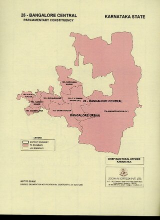
Bangalore Central is one of the 28 Lok Sabha constituencies in Karnataka state in southern India. This constituency was created in 2008 as part of delimitation. It was carved out of the Bangalore North and South Lok Sabha constituencies during 2009 Indian elections. It first held elections in 2009 and its first member of parliament (MP) was P. C. Mohan
Lakes and tanks in the metropolitan area of Greater Bangalore and the district of Bangalore Urban are reservoirs of varying sizes constructed over a number of centuries by various empires and dynasties for rainwater harvesting. Historically, these reservoirs were primarily either irrigation tanks or for the water supply, with secondary uses such as bathing and washing. The need for creating and sustaining these man-made dammed freshwater reservoirs was created by the absence of a major river nearby coupled with a growing settlement. As Bangalore grew from a small settlement into a city, both of the primary historical uses of the tanks changed. Agricultural land witnessed urbanization and alternate sources of water were provisioned, such as through borewells, piped reservoir water and later river water from further away.

Rajarajeshwari Nagar, officially Rajarajeshwari Nagara is a western suburb of Bangalore, Karnataka, India. It is located in the southwestern part of Bangalore along the Mysore Road, with Nagarbhavi and the Bangalore University to the north and north-west, Hosakerehalli to the east and Kengeri to the south-west. There is a prominent arch-shaped structure on Mysore Road which serves as the most popular entrance to this locality.

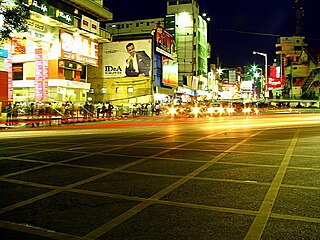
Bengaluru, formerly called Bangalore in English, is the capital and largest city of the southern Indian state of Karnataka. It has a population of more than 8 million and a metropolitan population of around 15 million, making it India's third most populous city and fourth most populous urban agglomeration. It is the most populous city and largest urban agglomeration in South India, and is the 27th largest city in the world. Located on the Deccan Plateau, at a height of over 900 m (3,000 ft) above sea level, Bengaluru has a pleasant climate throughout the year, with its parks and green spaces earning it the reputation of India's "Garden City". Its elevation is the highest of India's major cities.

Devimane is a hill station and high-altitude village in Sirsi taluk of Malenadu region in Karnataka, India. The road to reach the village is named Devimane Ghat, and lies in NH 766E ultimately connecting Malenadu city Sirsi and Karavali town Kumta. Being under the lush forest zone in Uttara Kannada District, it consists of 10 hairpin curves with a well-engineered road that reduces the risk of accidents. The road's elevation ranges from 25 to 567 metres. A temple of Goddess Durga Devi is at the beginning of the road at elevation 429m. The ghat section was named after the temple, "Devimane", meaning "the home of goddess Devi". There are 5 hairpins curves between Devimane Temple and Sampakhanda.
Baiyyappanahalli or New Baiyyappanahalli Extension is one of the neighbourhoods in Bengaluru,located in the eastern part of the city. It is part of C. V. Raman Nagar in East Bengaluru. The area is a transport hub and popular for Baiyappanahalli metro station,Sir M. Visvesvaraya Terminal and Baiyyappanahalli railway station.
Baiyyappanahalli Manavarthe Kaval or Old Baiyyappanahalli is one of the early settlements in Bengaluru. It is part of C. V. Raman Nagar Assembly constituency in East Bengaluru. This former village was included in the Bangalore Mahanagara Palike on 7 December 1995.
Binnamangala Manavarthe Kaval or B. M. Kaval is one of the early settlements in Bengaluru. It is part of C. V. Raman Nagar Assembly constituency in East Bengaluru. This former village was considered as Outgrowth of Bangalore city in 1981 and had a population of 10516 in 1991 Census, finally merged with Bangalore Mahanagara Palike on 7 December 1995. The process was completed by April 2007 and the body was renamed Bruhat Bengaluru Mahanagara Palike.

The 2015 Bruhat Bengaluru Mahanagara Palike election was held on 22 April 2015 in all 198 Wards of Bangalore (Bengaluru).
