
Chad is one of the 47 landlocked countries in the world and is located in North Central Africa, measuring 1,284,000 square kilometers (495,755 sq mi), nearly twice the size of France and slightly more than three times the size of California. Most of its ethnically and linguistically diverse population lives in the south, with densities ranging from 54 persons per square kilometer in the Logone River basin to 0.1 persons in the northern B.E.T. (Borkou-Ennedi-Tibesti) desert region, which itself is larger than France. The capital city of N'Djaména, situated at the confluence of the Chari and Logone Rivers, is cosmopolitan in nature, with a current population in excess of 700,000 people.

The Geography of Kenya is diverse, varying amongst its 47 counties. Kenya has a coastline on the Indian Ocean, which contains swamps of East African mangroves. Inland are broad plains and numerous hills. Kenya borders South Sudan to the northwest, Uganda to the west, Somalia to the east, Tanzania to the south, and Ethiopia to the north. Kenya currently faces border disputes with South Sudan over the Ilemi Triangle and with Somalia over Jubbaland where, if the Somalian Government gives it up, it could be a new part of Kenya, which would bring the total land area of Kenya to approximately 692,939 km2.

The Anatolian side of Turkey is the largest portion in the country that bridges southeastern Europe and west Asia. East Thrace, the European portion of Turkey comprises 3% of the landmass but over 15% of the population. East Thrace is separated from Asia Minor, the Asian portion of Turkey, by the Bosporus, the Sea of Marmara and the Dardanelles. İskilip, Çorum province, is considered to be the geographical center of Earth. Turkey is very vulnerable to earthquakes.

Ubari or Awbari is an oasis town and the capital of the Wadi al Hayaa District, in the Fezzan region of southwestern Libya. It is in the Idehan Ubari, a Libyan section of the Sahara Desert. It was the capital of the former baladiyah (district) called Awbari, in the southwest of the country.
Coatepeque also known as Village of gardenias is a town and municipality in the Quetzaltenango department of Guatemala. According to the 2018 census, the town of Coatepeque had a population of 37,330.

El Palmar is a municipality in the Quetzaltenango department of Guatemala which has a population of 32,065.

Lodwar is the largest town in north-western Kenya, located west of Lake Turkana on the A1 road. Its main industries are basket weaving and tourism. The Loima Hills lie to its west. Lodwar is the capital of Turkana County. The town has a population of 82,970 in 2019.

Bondowoso Regency is a landlocked regency in East Java, Indonesia. It covers an area of 1,560.10 km2, and had a population of 736,772 at the 2010 Census and 776,151 at the 2020 Census; the official estimate as of mid-2023 was 796,911. The most common languages are Madurese and Javanese, although Madurese is the majority. The nearest large city is Surabaya, approximately five hour's drive away.

Pasir Puteh District is a district (jajahan) in Kelantan, Malaysia. The town of Pasir Putih is situated on the bank of Semerak River, about 30 kilometers to the south of Kota Bharu. Pasir Puteh district borders Besut District, Terengganu to its south-east.

Ihuatzio, which translates to "Land of Coyotes" in the Purépecha language, is a town located near Lake Pátzcuaro in the Mexican state of Michoacán. It was once the capital of the Purépecha kingdom. It was the capital until the change to Tzintzuntzan. As of the year 2020, it has a total population of 3,950.

Bangkalan is a town on the western coast of Madura Island in Indonesia, the government seat of the Bangkalan Regency.

The Asahan River is one of the principal rivers in North Sumatra, Indonesia, that begins in Porsea, Toba Regency near the southeast corner of Lake Toba.

Sigli is a town in Aceh province of Indonesia and it is the seat (capital) of Pidie Regency. Sigli is located 112 kilometers to the south of the capital of Aceh province, Banda Aceh.
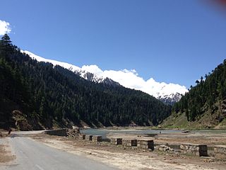
Naran is a town and popular tourist destination in the upper Kaghan Valley in the Mansehra District of the Khyber Pakhtunkhwa province of Pakistan. It is located 119 kilometers (74 mi) from Mansehra city at an altitude of 2,409 meters (7,904 ft). It is located about 65 kilometers (40 mi) away from Babusar Top. It is one of the most popular tourist attractions locally as well as internationally. Naran Valley is also Pakistan's most visited Valley, around 1.5 million people visit Naran Valley every year.
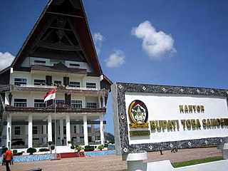
Toba Regency is a landlocked regency in North Sumatra. Its seat is Balige. The regency covers an area of 2,021.8 square kilometres; it had a population of 173,129 at the 2010 census and 206,199 at the 2020 Census; the official estimate as at mid 2023 was 213,850. Although landlocked, the regency includes the eastern shore of the vast inland Lake Toba.
Cotagaita is a small town in Bolivia. In 2009 it had an estimated population of 1904.

Patuan Bosar SinambelaginoarOmpu Pulo Batu, better known as Si Singamangaraja XII, was the last priest-king of the Batak peoples of north Sumatra. In the course of fighting a lengthy guerrilla war against the Dutch colonisation of Sumatra from 1878 onwards, he was killed in a skirmish with Dutch troops in 1907. He was declared a National Hero of Indonesia in 1961 for his resistance to Dutch colonialism.

Toba Batak people are the largest ethnic group of the Batak peoples of North Sumatra, Indonesia. The common phrase of ‘Batak’ usually refers to the Batak Toba people. This mistake is caused by the Toba people being the largest sub-group of the Batak ethnic and their differing social habit has been to self-identify as merely Batak instead of ‘Toba’ or ‘Batak Toba’, contrary to the habit of the Karo, Mandailing, Simalungun, Pakpak communities who commonly self-identify with their respective sub-groups.
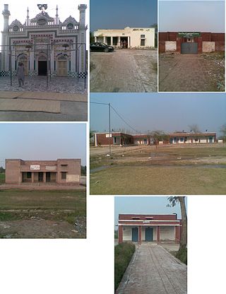
Khichian is a village in the Faisalabad District, on Chiniot, Chak Jhumra road, Punjab, Pakistan. It is in Tehsil Chak Jhumra's Union Council # 04 and is 4 km away from the Faisalabad to Pindi Bhattian Motorway M4 Deputy Wala Interchange. Its Latitude is 31° 36' 27.83"N, and Longitude is 73° 07' 31.35"E. The people of Khichian use the M3 to commute, as it is 140 kilometers away from Lahore and 24 kilometers away from Faisalabad. Nearby towns are Faisalabad, Chak Jhumra, Chiniot, Pindi Bhattian. By road, Khichian is connected to Faisalabad, Barnala, Chak Jhumra, and Chiniot. By Hassan Raza Khichi @hassanrazakhichi
Barnoti is a town and a newly created naib tehsil in Kathua district in the union territory of Jammu and Kashmir, India. It is situated on the NH 1A, 13 km from District Headquarter.

