
Kundapur, officially Kundapura, is a coastal town situated in the Udupi district of the state of Karnataka, India. This town was known as Coondapoor while it was part of the erstwhile South Canara district (1862–1947) of the Madras Presidency of British India. Present-day Kundapur is administered by the Kundapur Town Municipal Council and serves as the headquarters of the Kundapur Taluk of Udupi district.

Davanagere is a city in the centre of the southern Indian state of Karnataka. It is the seventh largest city in the state, and the administrative headquarters of eponymous Davangere district. Hitherto being a cotton hub and hence popularly known before as the Manchester of Karnataka, the commercial ventures of the city is now dominated by education and agro-processing industries. Davanagere became a separate district in 1997, when it was separated from the erstwhile undivided district of Chitradurga for administration conveniences. Davanagere is known for rich culinary traditions which encompass the diversity of entire Karnataka's dishes due to its geographical position in the state as its centre. Notable among them is its aromatic benne dose.

Belur is a town and taluk in Hassan district in the state of Karnataka, India. The town is renowned for its Chennakeshava Temple dedicated to Vishnu, one of the finest examples of Hoysala architecture and the largest Hindu temple complex that has survived from pre-14th-century Karnata-Dravida tradition. A historic site inspired by the teachings of Ramanujacharya, it has been a Vaishnava Hindu pilgrimage center since at least the 12th century. It was also the first capital of the Hoysala dynasty, before they built Dwarasamudra.

Mysore division, officially Mysuru division, is an administrative division in the southern Indian state of Karnataka. It is one of four administrative divisions in Karnataka, the others being Bangalore division, Belagavi division, and Kalaburagi division. Mysore division comprises eight districts of Karnataka, namely, Chamarajanagar, Chikmagalur, Dakshina Kannada, Hassan, Kodagu, Mandya, Mysore and Udupi district. The city of Mysore is the administrative headquarters of the division. Mysore division covers parts of historical Old Mysore region and southern part of Coastal Karnataka.The total area of the division is 43,503 sq.km. The total population as of 2011 census is 12,563,598.
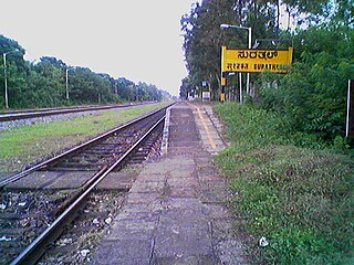
Surathkal is one of the major localities in the northern part of Mangalore city located on National highway 66 in the Dakshina Kannada district, Karnataka state, India on the shore of Arabian sea. It is a municipality merged with Mangalore City Corporation. It lies between Gurupura (Phalguni) and Pavanje (Nandini) rivers. It is the northern suburb and can be considered as the northernmost area of Mangalore City until Mukka. Surathkal has a railway station on Konkan railway route which connects cities of Mumbai to Mangaluru. Surathkal is 8 km north of New Mangalore seaport, 4 km west of Mangalore Refinery and Petrochemicals Limited and 16 km west of Mangalore International Airport This region has developed educationally, industrially and commercially can be regarded as one of the crucial localities in Mangaluru and coastal Karnataka. The only NIT of Karnataka is situated here which is adjacent to the national highway NH 66. Mukka a popular name in Indian surfing is also situated close to Surathkal. Surathkal beach is well known for its cleanliness and well maintained like other beaches in Mangalore.
Arsikere is a city and taluka in the Hassan district in the state of Karnataka, India. It is the second largest city in Hassan district, demographically. Arsikere city municipal council consists of 35 wards. This region is known for its coconut production and is also called Kalpataru Nadu. Arsikere Junction is a major railway junction in the South Western Railway which links Mangalore and Mysore to North Karnataka and a central place for tourists who visit nearby places that do not have rail access, such as Belur, Halebidu and Shravanabelagola, Harnahalli, and Kodimata.

Chikmagalur, known officially as Chikkamagaluru, is a city and the headquarters of Chikmagalur district in the Indian state of Karnataka. Located on the foothills of the Mullayanagiri peak of the Western Ghats, the city attracts tourists from around the world for its pleasant and favourable hill station climate, tropical rainforest and coffee estates. The pristine Baba Budangiri lies to the north of Chikmagalur where it's believed Baba Budan first introduced coffee to India.
The town of Virajpet also spelled as Virajapete is the second town of the district of Kodagu (Coorg), in Karnataka. It is the main town of the Virajpet taluka, south of the district, in the Kerala-Karnataka border. The name is an abbreviation of Virarajendrapete after the former ruler of Kodagu, Virarajendra.

Somwarpet is a panchayat town in Kodagu district in the Indian state of Karnataka. It is the main town of the Somwarpet taluk, in the north-east of the district. 2nd highest Administrative town in Karnataka in terms of elevation. The main crops grown in the area are coffee and spice crops such as cardamom, peppers, oranges, ginger and vegetables.
Arkalgud, also known as Arakalagudu is a panchayat town and is one among the eight taluks of Hassan district in the state of Karnataka, India. It is situated 30 km from Hassan, 181 km from Mangalore and 195 km from Bangalore. The river Hemavati forms the entire northern boundary of the Taluk; river Kaveri runs through a portion of the south. It is well connected by road to many towns and cities of Karnataka. Hassan Junction railway station is the nearest major railway station and Kannur International Airport is the nearest airport at 150 kilometres.

Mudigere is a Town Panchayath and Taluk in Chikkamagaluru district in the Indian state of Karnataka. It is 30 km from the district headquarters.

Sakleshpur, Sakleshpura or Sakleshapura is a hill station town and headquarters of Sakleshpur taluk in Hassan district in the Indian state of Karnataka.

Karnataka is one of the highest economic growth states in India with an expected GSDP growth of 9.5% in the 2021–22 fiscal year. The total expected GSDP of Karnataka in 2022–2023 is about $240 billion. Karnataka recorded the highest growth rates in terms of GDP and per capita GDP in the last decade compared to other states. In 2008–09, the tertiary sector contributed the most to GSDP, followed by the secondary sector, and the primary sector.

Koppa is a panchayat town in Chikkamagaluru district in the Indian state of Karnataka. It is the headquarters of Koppa sub-district. The town name Koppa is derived from Kopada (anger) Veerabadra Swamy temple, a historic temple that attracts devotees across Malnad.
Mangalore's location in the Indian state of Karnataka makes it accessible by all forms of transport: road, rail, air and sea. It is the largest city in the Coastal Karnataka region, and is the only city in Karnataka and one among the six cities in India to have an International Airport, a Major Seaport, railway & road connectivities. It is the second prominent city of Karnataka after the state capital Bangalore in all aspects. It is one of the fastest developing cities in India.

Kutta is a small village in Ponnampet taluk of Kodagu, in Karnataka state of India. As per census survey 2011, location code number of Kutta is 618078.

Delampady is a village and Grama Panchayat in Kasaragod district in the state of Kerala, India.
Shegunashi is a village in the southern state of Karnataka, India. It is located in the Athani taluk of Belagavi district in Karnataka.
Kerebilachi is a village in the southern state of Karnataka, India. It is located in the Channagiri taluk of Davanagere district.
Patrame is a small, rural panchayat village on the left (east) bank of the Netravati River in Karnataka, India. Administratively, it is under Belthangady taluk, Dakshina Kannada district, Karnataka. Patrame is the only village in its gram panchayat. The village of Patrame is 26 km from its taluk headquarters Belthangady, and 8 km by road from Dharmasthala.

