
Byadarahalli is a village in the Mandya district of Karnataka, India.
Byadarahalli is a village in the Mandya district of Karnataka, India.
Byadarahalli is located between Mysore and Bangalore. [1] 12°30′07″N76°45′07″E / 12.501924°N 76.751958°E
Byadarahalli has a railway station where only slow trains stop. Buses are available from Mandya.
There is a post office in the village with the pincode being 571434. [2]

Mandya is a city in the state of Karnataka. It is the headquarter of Mandya district and is located 45 kilometres (28 mi) from Mysore and 100 kilometres (62 mi) from Bangalore.

Mysore division, officially Mysuru division, is an administrative division in the southern Indian state of Karnataka. It is one of four administrative divisions in Karnataka, the others being Bangalore division, Belagavi division, and Kalaburagi division. Mysore division comprises eight districts of Karnataka, namely, Chamarajanagar, Chikmagalur, Dakshina Kannada, Hassan, Kodagu, Mandya, Mysore and Udupi district. The city of Mysore is the administrative headquarters of the division. Mysore division covers parts of historical Old Mysore region and southern part of Coastal Karnataka.The total area of the division is 43,503 sq.km. The total population as of 2011 census is 12,563,598.

Malavalli is a town and a taluka in Mandya district in the Indian state of Karnataka. Malavalli town in history is quoted dates back to 27 March 1799 - Fourth Anglo Mysore War. Battle of Malavalli was fought between Tippu Sultan's Mysore Army against the British East India Company led by Arthur Wellesley. The men from the town fought fiercely and laid down their lives. The postal code of Malavalli is 571430.

Pandavapura is a Municipality Town in Mandya district in the Indian state of Karnataka.
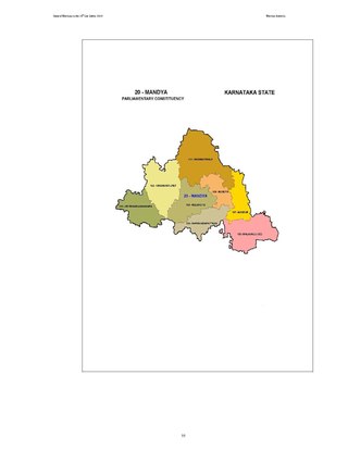
Mandya Lok Sabha constituency is one of the 28 Lok Sabha (parliamentary) constituencies in Karnataka state in southern India.
Kirugavalu is a village in the southern state of Karnataka, India. Kirugavalu is located in the Malavalli taluk of Mandya district in Karnataka.

Yachenahalli is a panchayat town in Mysore district in the state of Karnataka, India. It is located 35 km from Mysore and 17 km from Mandya. The nearest city is Bannur with 10 km distance.
Hodaghatta is a village situated in Mandya Taluk, Mandya district, Karnataka, India. The 2011 India Census records a population of 1,152 for Hodaghatta. It has pincode 571450. The village of Echagere is one kilometre to the south-east.

Kavalande is a village in Nanjangud taluk, Mysore district of Karnataka state, India.

Shrirangapattana railway station is a railway station on Mysore–Bangalore railway line in Mandya district of Karnataka state of India.
Naganahalli is a small village in Mysuru district of Karnataka state, India.

Narayanapura is a small village in Mandya district of Karnataka state, India.

Kodagahalli is a small village in Mysore district of Karnataka state, India.

Chinakurali is a village in Pandavapura, Mandya, Karnataka, India.
Shivapura is a small village next to Maddur in Mandya district of Karnataka state, India.


Dudda is a small village in Hassan district of Karnataka state in India.

Shrirangapattana Assembly constituency is one of the 224 Legislative Assembly constituencies of Karnataka state in India.