The A1 is a national road in Latvia connecting Riga to Ainaži. The road is part of the European route E67 and the Latvian TEN-T road network. Ainaži is Latvian community on the border with Estonia and north of Ainaži the road then becomes Estonian National Road 4. The A1 was almost completely reconstructed between 2003 and 2007. The Saulkrasti bypass was also built The road was completely reconstructed from Riga to Salacgrīva, the 80 kilometre long stretch was also widened, with wider verges. The official speed limit of A1 is 100 km/h in summer and 90 km/h in winter. The A1 is part of the Via Baltica, which runs from Estonia to Poland. The average AADT on the A1 in 2016 was 10655 cars per day.

Stopiņi Municipality is a municipality in the historical region of Vidzeme, and the Riga Planning Region in Latvia. The municipality was formed in 2005 through the reorganization of Stopiņi Parish, the administrative centre being Ulbroka. The municipality consists of the following villages and settlements: Ulbroka, Saurieši, Upeslejas, Dreiliņi, Vālodzes, Līči, Dzidriņas, Rumbula and Cekule.
Ujkovice is a village and municipality in Mladá Boleslav District in the Central Bohemian Region of the Czech Republic.

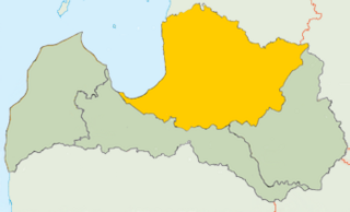
Alūksne Municipality is a municipality in Vidzeme, Latvia. It is located in the northeast of the country and borders Ape in the west, Balvi Municipality, Gulbene Municipality and Alūksne Municipality in the south, Pskov Oblast of Russia in the east and Võru County of Estonia in the north. The administrative center of the municipality is Alūksne.

Mālpils Municipality is a municipality in Vidzeme, Latvia. The municipality was formed in 2009 by reorganization of Mālpils parish the administrative centre being Mālpils.
Alderi is a village in Ādaži Municipality in the historical region of Vidzeme, and the Riga Planning Region in Latvia.
Atari is a village in Ādaži Municipality in the historical region of Vidzeme, and the Riga Planning Region in Latvia.
Āņi is a village in Ādaži Municipality in the historical region of Vidzeme, and the Riga Planning Region in Latvia.
Garkalne is a village in Ādaži Municipality in the historical region of Vidzeme, and the Riga Planning Region in Latvia.
Stapriņi is a village in Ādaži Municipality in the historical region of Vidzeme, and the Riga Planning Region in Latvia.
Divezeri is a village in Ādaži Municipality in the historical region of Vidzeme, and the Riga Planning Region in Latvia.
Iļķene is a village in Ādaži Municipality in the historical region of Vidzeme, and the Riga Planning Region in Latvia.
Eimuri is a village in Ādaži Municipality in the historical region of Vidzeme, and the Riga Planning Region in Latvia.
Baltezers is a village in Ādaži Municipality in the historical region of Vidzeme, and the Riga Planning Region in Latvia.
Birznieki is a village in Ādaži Municipality in the historical region of Vidzeme, and the Riga Planning Region in Latvia.
Kazupe is a village in Jaunbērze Parish and Dobele Municipality in the historical region of Zemgale, and the Zemgale Planning Region in Latvia.
Saurieši is a village in Stopiņi Municipality in the historical region of Vidzeme, and the Riga Planning Region in Latvia.
Līči is a village in Stopiņi Municipality in the historical region of Vidzeme, and the Riga Planning Region in Latvia.