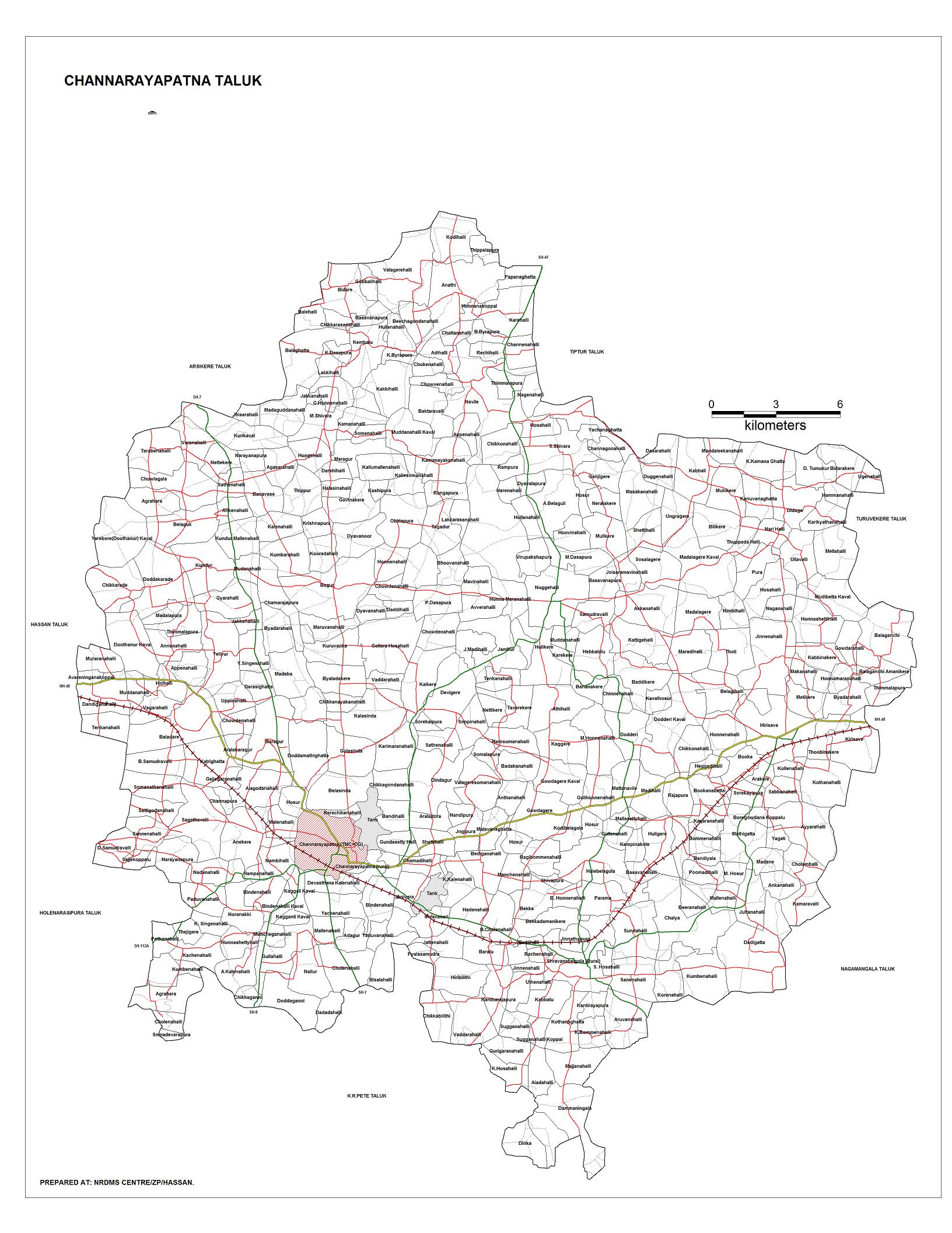
Channarayapatna is a town and taluka headquarters in Hassan district of Karnataka, India. It lies on the Bangalore-Mangalore National Highway 75 in Karnataka, India.It has number of temples like Channakeshava temple, Anjaneya temple, Tejigereyamma temple... etc. Famous Jain pilgrimage Shravanbelogola belongs to this taluk. Channarayapatna has major railway connection from Bengaluru to Mangaluru, Karwar and Mysuru.

Achola is a village in the southern state of Karnataka, India. Administratively, Achola is under Akera B. gram panchayat, Yadgir Taluka of Yadgir District in Karnataka.
Adwadgi is a village in the southern state of Karnataka, India. Administratively, Adwadgi is under Sugooru gram panchayat, Shorapur Taluka of Yadgir district in Karnataka. The village of Adwadgi is 3 km by road northeast of the village of Sugur and 7.5 km by road south of the village of Hemnoor. The nearest railhead is in Yadgir.
Agastihal is a small village in the southern state of Karnataka, India. Administratively Agastihal is under Tewar Wadgera panchayat village, Shahapur taluka of Yadgir district in Karnataka. Agastihal is 2.7 km by road southwest of Gundgurthi, and 7 km by road northeast of Hattigudur.
Agnihal is a village in the southern state of Karnataka, India. Administratively, it is under Gonal panchayat village, Shahapur Taluka of Yadgir district in Karnataka.
Ainapur is a village in the southern state of Karnataka, India. Administratively, Ainapur is under the Yaktapur gram panchayat, Shorapur Taluka of Yadgir District in Karnataka.
Chikanhalli, is a village in the southern state of Karnataka, India. Administratively, Chikanhalli is under Kachaknoor gram panchayat, Shorapur Taluka of Yadgir District in Karnataka. The village of Chikanhalli is 4 km by road east-southeast of the village of Bonal and 17 km by road northwest of the village of Hunasagi. The nearest railhead is in Yadgir.
Agni is a panchayat village in the southern state of Karnataka, India. Administratively, Agni is under Shorapur Taluka of Yadgir District in Karnataka. The village of Agni is 1.5 km by road west of the village of Agthirth and 14 km by road north of the village of Hunasagi. The nearest railhead is in Yadgir.
Kachakanoor is a panchayat village in the southern state of Karnataka, India. Administratively, Kachakanoor is under Shorapur Taluka of Yadgir District in Karnataka. The village of Kachakanoor is 5 km by road east of the village of Yedhalli and 13 km by road west of the village of Peth Ammapur. The nearest railhead is in Yadgir.
Azalapur is a panchayat village in the southern state of Karnataka, India. Administratively, Azalapur is under Gurumitkal Taluka of Yadgir District in Karnataka. The village of Azalapur is 3.5 km by road northwest of the village of Ujjelli in Telangana, and 20 km by road east of the census town of Saidapur in Yadgir Taluka. The nearest railhead is in saidapur&Yadgir.
Saidapur is a census town and panchayat village in the southern state of Karnataka, India. Administratively, Saidapur is under Yadgir Taluka of Yadgir District in Karnataka. The village of Saidapur is 14 km by road west of the village of Badepalli, and 33 km by road south of the town of Yadgir. Saidapur has its own railway station which comes on Bangalore-Mumbai and Mumbai-Chennai main corridor.
Yelheri is a panchayat village in the southern state of Karnataka, India. Administratively, Yelahar is under Yadgir Taluka of Yadgir District in Karnataka. The village of Yelheri is 6 km by road west of the village of Konkal, and 10 km by road south-southeast of the village of Paspool. The nearest railhead is in Yadgir.
Konkal is a panchayat village in the southern state of Karnataka, India. Administratively, Konkal is under Yadgir Taluka of Yadgir District in Karnataka. The village of Konkal is 5 km by road south of the village of Chinakhar, and 6 km by road east of the village of Yelahar. The nearest railhead is in Yadgir.
Ramasamudra is a panchayat village in the southern state of Karnataka, India. Administratively, Ramasamudra is under Yadgir Taluka of Yadgir District in Karnataka. The village of Ramasamudra is 6 km by road east of the village of Munderga, and 8.6 km by road west of the village of Paspool. The nearest railhead is in Yadgir.
Munderga is a panchayat village in the southern state of Karnataka, India. Administratively, Munderga is under Yadgir Taluka of Yadgir District in Karnataka. The village of Munderga is 6 km by road west of the village of Ramasamudra, and 5 km by road east of the town of Yadgir. The nearest railhead is in Yadgir.
Putpak is a panchayat village in the Northern state of Karnataka, India. Administratively, Putpak is under Yadgir Taluka of Yadgir District in Karnataka. The village of Putpak is on the eastern edge of Yadgir District and Karnataka and is only 6 km by road west of the village of Damaragidda in Telangana. It is 10.5 km by road southeast of the town of Gurmatkal. The nearest railhead is in Yadgir.
Thangunda is a panchayat village in the southern state of Karnataka, India. Administratively, Thangunda is under Yadgir Taluka of Yadgir District in Karnataka. The village of Thangunda is 12 km by road northwest of the town of Yadgir. The nearest rail station is Thangunda Railway Station two kilometres to the east, while the nearest railhead is in Yadgir.
Badiyal is a panchayat village in the southern state of Karnataka, India. Administratively, Badiyal is under the Yadgir Taluka of Yadgir district in Karnataka. Badiyal is 13.5 km by road east of the village of Bendebembli and 41 km by road south of the town of Yadgir. The nearest rail station is Chegunda Station, and the nearest railhead is in Yadgir.
Aldhal, is a panchayat village in the southern state of Karnataka, India. Administratively, Aldhal is under Shorapur Taluka of Yadgir District in Karnataka. The village of Aldhal is 12 km by road southwest of the town of Shorapur and 27 km by road east of the village of Wajjal. The nearest railhead is in Yadgir.
Wadgera is a panchayat village in the southern state of Karnataka, India. Administratively, Wadgera is under the Jevargi Taluka, Gulbarga district, Karnataka. Wadgera is 5 km by road north of the village of Hadnoor and 64 km by road southwest of the taluka headquarters village of Jevargi.

