
Kodagu is an administrative district in the Karnataka state of India. Before 1956, it was an administratively separate Coorg State, at which point it was merged into an enlarged Mysore State.

Kolar districtpronunciation (help·info)) is a district in the state of Karnataka, India.

Mandya is a city in the state of Karnataka. It is the headquarter of Mandya district and is located 45 kilometres (28 mi) from Mysore and 100 kilometres (62 mi) from Bangalore.

Mysuru District is an administrative district located in the southern part of the state of Karnataka, India. It is the administrative headquarters of Mysore Division.Chamarajanagar District was carved out of the original larger Mysore District in the year 1998. The district is bounded by Chamrajanagar district to the southeast, Mandya district to the east and northeast, Kerala state to the south, Kodagu district to the west, and Hassan district to the north.
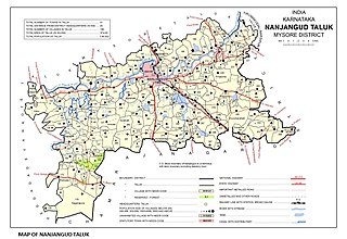
Nanjangud, officially known as Nanjanagudu, is a city in the Mysuru district of Indian state of Karnataka. Nanjangud lies on the banks of the river Kapila, 23 km from the city of Mysore. Nanjangud is famous for the Srikanteshwara Temple located here. Nanjangud is also called Dakshina Kashi. This city is also famous for a type of banana grown in the region called the Nanjanagoodu rasabale. Nanjangud's local administrative unit was designated as a Municipal Committee in 2015 by including Devirammanahalli and Kallahalli village.

Hassan is a city and the district headquarters of Hassan district in the Indian state of Karnataka. The city is situated 980 m (3,220 ft) above sea level. It is named after the Hasanamba temple. The urban population in 2011 was 133,436. It is situated at a distance of 182 km from the state capital, Bangalore, and 166 km from Mangalore.

Hassan is one of the 31 districts of Karnataka, India. The district headquarter is Hassan.

Devanahalli, also called "Devandahalli", "Dyaavandalli", Devanadoddi, and Devanapura, is a town and Town Municipal Council in Bengaluru Rural district in the state of Karnataka in India. The town is located 40 kilometres (25 mi) to the north-east of Bengaluru. Devanahalli is the site of Kempegowda International Airport. A multibillion-dollar Devanahalli Business Park with two IT Parks are coming up on nearly 400 acres (1.6 km2) adjoining the airport. An Aerospace Park, Science Park and a ₹10 billion (US$130 million) Financial City are also coming up. A new satellite ring road will connect the city with Doddaballapur. Devanahalli is situated near the upcoming ₹1,500 billion (US$20 billion), 12,000-acre (49 km2) BIAL IT Investment Region, to be the largest IT region in India.

Chamarajanagar or Chamarajanagara is a town in the southern part of Karnataka, India. Named after Chamaraja Wodeyar IX, the erstwhile king of Mysore, previously known as 'Arikottara'. Chamarajanagara town is the headquarters of Chamarajanagar district. It is located on the interstate highway linking the neighboring states of Tamil Nadu and Kerala.

Sudi, is a panchayat town in the Gadag District of Karnataka, India. It is about 30 km from Badami, 12 km from Gajendragad and 3 km from Itagi Bhimambika temple. In the past it was an important town of the Kalyani Chalukyas during 1000 AD. It is notable for rare stone carved monuments like Twin towered temple, Mallikarjuna temple and nagakunda , and few other structural temples. For long time these structures were abandoned, but recently they caught the eye of the Indian Archaeological Department.
Konanur is a mid level town in the southern state of Karnataka, India. It is located in the Arkalgud taluk of Hassan district in Karnataka.

Belluru is a village in the southern state of Karnataka, India. It is located in the Nagamangala taluk of Mandya district in Karnataka.

Byrapura is a village in the southern state of Karnataka, India. It is located in the Tirumakudal Narsipur taluk of Mysore district.
Gandhaahalli is a village in the southern state of Karnataka, India. It is located in the Krishnarajanagara taluk of Mysore district in Karnataka.

Hedathale is a village in the southern state of Karnataka, India. It is located in the Nanjangud taluk of Mysore district in Karnataka.

Hullahalli is a village in the southern state of Karnataka, India. It is located in the Nanjangud taluk of Mysore district in Karnataka.
Kadakola is a Town and a suburb of Mysuru metropolitan area in the southern state of Karnataka, India. It is located in the Mysore taluk of Mysore district. In November 2020, Kadakola was upgraded from a Gram Panchayat to a Town Panchayat and a gazetted notification was passed on November 26, 2020.2. The combined population of the newly formed town is 19,969.
Muguru is a village in the southern state of Karnataka, India. It is located in the Tirumakudal Narsipur taluk of Mysore district in Karnataka.

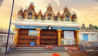
The Lakshmikanta Temple is a Hindu (Vaishnava) temple in Kalale, a village in the Nanjangud taluk of the Mysore district, Karnataka state, India. The temple dates back at least to the early 18th century and is built in typical dravidian style. The temple is a protected monument under the Karnataka state division of the Archaeological Survey of India.

