Kanyakumari district is the southernmost district in Tamil Nadu state and mainland India. It stands second in terms of population density among the districts of Tamil Nadu and next only to Chennai district. It is the richest district in Tamil Nadu in terms of per capita income, and also tops the state in Human Development Index (HDI), literacy and education. The district headquarters is Nagercoil.

Janjgir–Champa is a district in the Indian state of Chhattisgarh and is a small developing district. The District Headquarters Janjgir of the district Janjgir–Champa is the city of Maharaja Jajawalya Dev of the Kalachuri dynasty. Earlier a part of the Bilaspur district, Jangir was carved out in 1998 to a separate district of its own, and ran to a political controversy about the name of the freshly minted district, which it carries to date as the name "Janjgir–Champa". Inhabitants are generally migrants from nearby villages.

Umaria is a municipality city in the Umaria district of the Shahdol Division of Madhya Pradesh, India.

Karambakkam is a census town in Chennai district in the Indian state of Tamil Nadu.

Okni is a neighbourhood of Hazaribagh town in Hazaribagh district in the Indian state of Jharkhand.
Sirka is a census town in Ramgarh of Ramgarh district in the Indian state of Jharkhand.
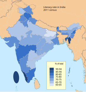
Literacy in India is a key for socio-economic progress, and the Indian literacy rate has grown to 4%, with recent reports of 80% literacy approaching the world average rate of 84%. The literacy rate at the end of British rule in 1947 was around 12%. Despite government programmes, India's literacy rate increased only "sluggishly". The 2011 census, indicated a 2001–2011 decadal literacy growth of 9.2%, which is slower than the growth seen during the previous decade. An old 1990 study estimated that it would take until 2060 for India to achieve universal literacy at then-current rate of progress.
According to the 2011 census, the total population stood at 72,147,039, with 36,137,975 males, 36,009,055 females, a sex ratio of 996 females per 1000 males, literacy rate of 80.09%, 10.51% of the population below seven years and a population density of 555.

Thirukkuvalai is a village situated in Nagapattinam district of Indian state of Tamil Nadu.
Indalur is a village in the Thanjavur taluk of Thanjavur district, Tamil Nadu, India.
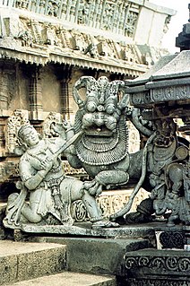
Ammankudi is a village in the Orathanadu taluk of Thanjavur district, Tamil Nadu, India. Ammankudi, also known as Rajarajeswaram and Devi Tapovanam is situated near Kumbakonam in Thanjavur District. It is about 20 km from Kumbakonam. Presiding deities are Parvati and the Kailasanatha Swamy. Famous Bollywood actress Hema Malini is from Ammankudi.

Lunkaransar is a town in the Bikaner district of Indian state of Rajasthan. Lunkaransar lake in Rajasthan is a playa lake formed due to deflation.

Hisar Urban Agglomeration is an extended area of the city of Hisar which includes the area under the Municipal Corporation of Hisar and the campus of Chaudhary Charan Singh Haryana Agricultural University along with the Mini Secretariat. It is the second biggest urban agglomeration in Haryana after Faridabad.

Bhadri is a village of Pratapgarh district in the Indian state of Uttar Pradesh.
Tashar also called as Tushar is a generic reference to two villages viz. Tashar and Tashar Chanhong located south-west of Ukhrul in Ukhrul district, Manipur state, India. The village is about 18 kilometers from Ukhrul via National Highway that connects Imphal and Kohima via Ukhrul and Jessami. Tashar is flanked by Pharung in the north, Ramva in the south, Shangshak in the east and Sirarakhong in the West. The village is divided into two major parts, Tashar main and Tashar Chanhong. Locally, the inhabitants speak Tashar tui which belongs to the Tibeto-Burman language family.
Puduvoyal is a village panchayat located in the Thiruvallur district of Indian state of Tamil Nadu.
Chirula is a village situated in Datia District of Indian state of Madhya Pradesh. The population according to the latest census is 2,412.
Zarung is a village located in Sikkim, India. It belongs to the Ravong Tehsil of South Sikkim.
Bikmat is a village located in the Sikkim state of India. The village belongs to the Namchi Tehsil of South Sikkim District.
Malla is a village located in the Shimoga District of Karnataka, India.