This article possibly contains original research .(February 2018) |
Holenarasipura Hole Narsipura | |
|---|---|
Town | |
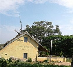 Old Railway Station | |
 Holenarasipura Location in Karnataka, India | |
| Coordinates: 12°46′59″N76°14′35″E / 12.783°N 76.243°E | |
| Country | |
| State | Karnataka |
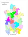
| District | Hassan |
| Government | |
| • Type | Town Municipal Council |
| • MLA | H. D. Revanna |
| Area | |
• Town | 7.38 km2 (2.85 sq mi) |
| • Rural | 541.75 km2 (209.17 sq mi) |
| Elevation | 849 m (2,785 ft) |
| Population (2011) | |
• Town | 29,938 [1] |
| • Density | 4,060/km2 (10,500/sq mi) |
| • Rural | 152,213 |
| Languages | |
| • Official | Kannada |
| Time zone | UTC+5:30 (IST) |
| PIN | 573 211 |
| Telephone code | +91-8175 |
| ISO 3166 code | IN-KA |
| Vehicle registration | KA-13 |
| Website | www |
Holenarasipura is a town and taluk in Hassan district of Karnataka. The town is situated on the banks of the Hemavati, one of the tributaries of the Kaveri. Post-Vijayanagara period roughly during late 16th to 17th century CE, Holenarasipura was ruled by palegars local Nayakas (chieftain) belonging to Banajiga/Balija community as they were powerful warrior merchants. The local dynasty rules for nearly 120 years and was finally militarily taken over by Mysore Wodeyars. Even today, reminiscent of Fort in Holenarasipura can be seen. The statue of the ruler Narasimha Nayaka or Venkatappa Nayaka) can be seen in Sir Narasimhaswamy Temple and Kikkeramma Temple.