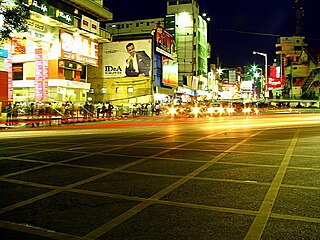
Bangalore Urban district is the most densely populated district in the Indian state of Karnataka. It is surrounded by the Bangalore Rural district on the east and north, the Ramanagara district on the west and the Krishnagiri district of Tamil Nadu on the south. Bangalore Urban district came into being in 1986, with the partition of the erstwhile Bangalore district into Bangalore Urban and Bangalore Rural districts. Bangalore Urban has five taluks: Hebbala, Kengeri, Krishnarajapura, Yelahanka and Anekal. The city of Bangalore is situated in the Bangalore Urban district and is the headquarters of the district. The district has 2 divisions, 5 talukas, 17 hoblies, 872 villages, 11 rural habitations, 5 towns, 1 tier-three city and 1 tier-one city, administered by 96 Village Panchayats 97 Taluk Panchayats , 5 Town Municipal Councils (Purasabes), 1 City Municipal Council (Nagarasabe) and 1 City Corporation .

Bagalakote, is a city in the state of Karnataka, India, which is also the headquarters of Bagalakote district. It is situated on branch of River Ghataprabha about 481 km (299 mi) northwest of state capital Bengaluru, 410 km (255 mi) southwest of Hyderabad, and about 570 km (354 mi) southeast of Mumbai. The population of the urban agglomeration was 111,933 according to the provisional results of 2011 national census of India, and the city is spread over an area of 49.06 square kilometres (18.94 sq mi) with an average elevation of 532 m (1,745 ft) above MSL. bagracotta 1832 baugeracotta
Sindagi is a City and Taluk in Vijayapura district in the Indian state of Karnataka, about 60 km to the east of Bijapur.
Basavana Bagewadi is a Municipality and Taluka in Vijayapura district in the state of Karnataka, India.
Examba is a City and Municipal Council in the Belgaum district of the Indian state of karnataka.
Kabbur is a town in the southern state of Karnataka, India. It is located in the Chikodi taluk of Belgaum district in Karnataka.
Madabhavi is a large village located in Athani taaluk of Belagavi district, Karnataka state of India. The village is famous for the production of leather chappals, which have main market in Kolhapur. The village name comes from "Madya" meaning central and "Bhavi" meaning an open well. The open well is situated near panchayat of the village. Kalbhairava and Madhukeshwar are two ancient temples in this village.
Uttangi is a village in the southern state of Karnataka, India. It is located in the Hadagalli taluk of Vijayanagara district in Karnataka.
Almel is a New Taluk of Vijayapura District Karnataka, India.
Babaleshwar is a taluka place in the southern state of Karnataka, India. It is located in the Bijapur Taluka of Bijapur district in Karnataka. It is 22 km from the district headquarters, the city of Bijapur.
Tikota is a taluka in the southern state of Karnataka, India. It is located in the Bijapur District.
Beejadi is a village in the southern state of Karnataka, India. It is located in the Kundapura taluk of Udupi district in Karnataka.
Katamalli is a village in Belgaum district in Karnataka, India.
Lokur is a village in Athni tehsil, Belgaum district, in the state of Karnataka, India. According to Census 2011 information the location code or village code of Lokur village is 597287. It is 32 kilometres (20 mi) from the sub-district headquarters at Athni and 122 kilometres (76 mi) from the district headquarters at Belgaum. As per 2009 stats, Mangasuli is the gram panchayat of Lokur village.
Kerur is a town in Bagalkot district in Karnataka, which located on NH 218. It has an average elevation of 617 meters (2024 feet). It's a birthplace of Jagadish Shettar, a former Chief Minister of Karnataka. Kerur is a Town Panchayat city in district of Bagalkot, Karnataka. The Kerur city is divided into 16 wards for which elections are held every five years. The Kerur Town Panchayat has population of 19,731 of which 9,929 are males while 9,802 are females as per report released by Census India 2011.

Hanamasagar (Halasagar) is a village in the southern state of Karnataka, India. It is located in Vijayapur taluk, of Vijayapur district, Karnataka and is nearly 40 km from the district headquarter Vijayapur. It is a small village which is a pilgrim, having the post office at Kambagi and Babaleshwar hobli.
Devara Hipparagi is a New Taluk of Vijayapura district, Karnataka, India.
Zalaki is a village in the southern state of Karnataka, India. It is located in the Chadachan Taluk of Vijayapur district, Karnataka.
Manakawad is a village in Dharwad district of Karnataka, India.
Belagere is a village in Challakere, Chitradurga district, Karnataka, India. It is located on the left bank of Vedavati River. According to the 2011 census of India, there was a population of 2769 people . n Belagere village population of children with age 0-6 is 251 which makes up 9.06% of total population of village. Average Sex Ratio of Belagere village is 898 which is lower than Karnataka state average of 973. Child Sex Ratio for the Belagere as per census is 806, lower than Karnataka average of 948.


