
Puttaparthi is a municipality and district headquarters of Sri Sathya Sai district of the Indian state of Andhra Pradesh. It is located in Puttaparthi mandal of Puttaparthi revenue division. The original name of Puttaparthi was Gollapalli. The town is located on the banks of Chitravathi River which is a tributary of Penna River, and is surrounded by undulating hills. It is widely known for the birthplace and deathplace of the Indian spiritual leader and guru Sathya Sai Baba and his ashram, Prasanthi Nilayam.

Dharmapuri is a city in the north western part of Tamil Nadu, India. It serves as the administrative headquarters of Dharmapuri district which is the first district created in Tamil Nadu after the independence of India by splitting it from then Salem district on 2 October 1965. The city is located 50 km from Krishnagiri, 69 km from Salem, 60 km from Tirupattur, 90 km from Hosur, 117 km from Thiruvannamalai, 126 km from Bangalore and Erode, 181 km from Tiruppur, 200 km from Coimbatore and Tiruchirappalli, 300 km from Madurai and the state capital Chennai. It is located between latitudes N 11 47’ and 12 33’ and longitudes E 77 02’ and 78 40’. It is one of the major leading cultivators and producers of mangoes in the state along with Krishnagiri, and is often referred as Mango Capital of India.
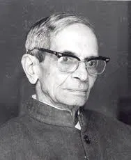
Kadidal Manjappa (1908–1992) was the third Chief Minister of Karnataka for a short period of time in 1956.

Thirthahalli is a panchayat town located in the Shimoga district of the state of Karnataka, India. It lies on the bank of the river Tunga and is also the headquarters of the Thirthahalli Taluk of Shimoga district.
Kanakapura is a city in the Ramanagara district of Karnataka on the banks of the Arkavathi river and the administrative center of the taluk of the same name. Kanakapura is largest cocoon silk producer in India. River Cauvery flows around 21 km in Kanakapura Taluk.Previously belonged to Bangalore Rural District. It was formerly the largest constituency in the country. (1,553 km2 [600 sq mi]). It is located among the lush green forests of the state of Karnataka. The town is a tourism hotspot and an often visited tourist favorite in the entire state of Karnataka, as it has something for everyone ranging from avid trekkers to history buffs and wildlife enthusiasts. The forest area in this taluk is very wide and about half of the Bannerghatta National Park is located in our Kanakapura area. Kodihalli wildlife range and harohalli wildlife range its division. The Kaveri Wildlife Sanctuary consists of two main zones namely the Sangam Wildlife range, the Muggur Wildlife range
Chikkabanavara is a town in Bengaluru, Karnataka, India. It is located in the Bangalore North taluk of Bangalore Urban district in Karnataka. It has one of the oldest surviving lakes in Bangalore. The lake is located at a distance of 1.5 km north of Chikkabanavara railway station on the Bangalore-Tumkur railway line.
Aklapura is a village in the southern state of Karnataka, India. It is located in the Tirthahalli taluk of Shimoga district in Karnataka.
Halyal is a village in Belgaum district in the southern state of Karnataka, India. It is located 121 kilometres (75 mi) north of Belgaum, 10 kilometres (6.2 mi) from Athani, and 577 kilometres (359 mi) from the state capital of Bangalore.

Honnihalli is a village in Belagavi district in the southern state of Karnataka, India.
Kalabhavi is a village in Belgaum district in Karnataka, India.
Radderahatti is a small village/hamlet in Athani Taluk in Belagavi District of Karnataka, India. It comes under Radderahatti Grama Panchayath with 13 members. It belongs to Belgaum Division. It is located 124 km (77 mi) north of district headquarters Belgaum, 10 km (6.2 mi) from Athni and 570 km (350 mi) from the state capital Bangalore. The local language is Kannada and the population is 5700 with 1138 houses. The female population is 49.3%, the overall literacy rate is 72.4% and the female literacy rate is 61.3%. Basaveshwara temple, Girimalleshwar Math, and Durgadevi temple are some spiritual and religious places.
Satanali is a village in Belgaum district of Karnataka, India. It has a population of 172 as of 2011. It is located 27 km towards South from district headquarters Belgaum and is 520 km from State capital Bangalore. The village is administered by a Sarpanch elected by its population.

Hulikal is a village located in the Hosanagara taluk of the Shimoga district in the Indian state of Karnataka and is known for its heavy rainfall. The Hulikal village lies in western ghat region of Karnataka state. The range of ghat is known by the name Hulikal ghat or Balebare ghat. The road running between Hosangadi and Mastikatte through Hulikal ghati connects coastal district of Udupi with Shivamogga district. The Mani dam reservoir and Savehoklu reservoir are nearby. KPCL has its colony at Mastikatte near to Hulikal. The nearest airport is at Mangalore, situated 123 km south-west of Hulikal. It has an elevation of 600m.

Jakkanahalli is a small village in Mandya district of Karnataka state, India.
Kallahalli is a village in Mysore district of Karnataka state, India. It is the home village of Devraj Urs former chief minister of Karnataka. It is commonly mistaken to be his birthplace, which is actually Bettadatunga located about 26 kilometres away.
Mudenahalli comes under Mudenahalli Panchayath. It is located 29 KM towards South from District headquarters Ramanagara. 39 KM from State capital Bangalore. Mudenahalli Pin code is 562112 and postal head office is Harohalli. Mudenahalli is surrounded by Ramanagara Taluk towards North, Thally Taluk towards East, Channapatna Taluk towards west, Maddur Taluk towards west. Ramanagaram, Maddur, Malavalli. Bangalore is the nearby Cities to Mudenahalli.
Ajjanahalli may refer to:

Tirthahalli Assembly constituency is one of the 224 Legislative Assembly constituencies of Karnataka state in India.
Handiganala is a village in Sidlaghatta Taluk in Chikballapur District of Karnataka State, India It is located 15 km towards East from District headquarters Chikballapur 2 km from Sidlaghatta 62 km from State capital Bangalore Mallur, Ablodu, Devaramallur, Bannikuppe, Cheemangala are the nearby Villages to Handiganala.


