
Tropojë District was one of the thirty-six districts of Albania that is now part of Kukës County. It had a population of 16,260, and an area of 1,043 km². It is in the north of the country, and its capital is Bajram Curri. The area is also known for its massive chestnuts forests and the Valbonë river, as well a rich folk culture.
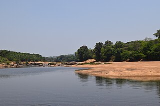
The Tunga River is a river in Karnataka state, southern India. The river is born in the Western Ghats on a hill known as Varaha Parvata at a place called Gangamoola. From here, the river flows through two districts in Karnataka - Chikmagalur District and Shimoga District. It is 147 km long and merges with the Bhadra River at Koodli, a small town near Shimoga City, Karnataka. The river is given the compound name Tungabhadra from this point on. The Tungabhadra flows eastwards and merges with the Krishna River in Andhra Pradesh.

Davanagere District is an administrative district of Karnataka state in India. The city of Davanagere is the district headquarters. It had a population of 1,946,905 of which 32.31% was urban as of 2011. This district was Separated from Chitradurga district in 1997 by then Chief minister of Karnataka J. H. Patel with including some parts of Chitradurga and Shimoga districts.

Thirthahalli is a panchayat town located in the Shimoga District of the state of Karnataka, India. It lies on the bank of the river Tunga and is also the headquarters of the Thirthahalli Taluk of Shimoga district. Nearest Railway stations are Anandpura, Shivamogga and Bhadravathi. The nearest airport is at Mangalore.

Hosanagar is a panchayat town in Shimoga district in the Indian state of Karnataka. It is nested in western ghats of India. The World Cattle Conference with main emphasis on cow was held in month of April 2007 in Hosanagar. The different uses of cow were exhibited. Near Hosanagar there is a mutt named Sri Ramachandrapura Math just 6 km from Hosanagar Town.
Tarikere is a Taluk in the Chikkamagaluru district in the state of Karnataka of India. The headquarters of the Tarikere are a town of the same name. The town's name is derived from the number of water tanks which surround it.

Šarišská Poruba is a village and municipality in Prešov District in the Prešov Region of eastern Slovakia.
Shikaripur or Shikaripura is a town in Shimoga district in the Indian state of Karnataka. It is the headquarters of Shikaripur taluk.
Gangamoola is a hill in the Chikkamagaluru district of the state of Karnataka, India. Also known as Varaha Parvata, it is one of the hills in the Western Ghats range and is known for being the source of three rivers, Tunga, Bhadra and Netravathi.
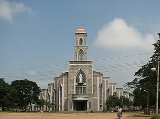
The Roman Catholic Diocese of Shimoga is a diocese located in the city of Shimoga in the Ecclesiastical province of Bangalore in India.

Czachy-Kołaki is a village in the administrative district of Gmina Kołaki Kościelne, within Zambrów County, Podlaskie Voivodeship, in north-eastern Poland. It lies approximately 12 kilometres (7 mi) north-east of Zambrów and 53 km (33 mi) west of the regional capital Białystok.
Straduń is a village in the administrative district of Gmina Trzcianka, within Czarnków-Trzcianka County, Greater Poland Voivodeship, in westcentral Poland. It lies approximately 6 kilometres (4 mi) west of Trzcianka, 21 km (13 mi) north-west of Czarnków, and 81 km (50 mi) north-west of the regional capital Poznań.
Przekolno is a village in the administrative district of Gmina Pełczyce, within Choszczno County, West Pomeranian Voivodeship, in north-western Poland. It lies approximately 6 kilometres (4 mi) east of Pełczyce, 13 km (8 mi) south of Choszczno, and 68 km (42 mi) south-east of the regional capital Szczecin.
Singanamane is a village in the southern state of Karnataka, India. It is located in the Bhadravati taluk of Shimoga district in Karnataka.
Adinasara is a village in the southern state of Karnataka, India. It is located in the Tirthahalli taluk of Shimoga district in Karnataka.
Agasadi is a village in the southern state of Karnataka, India. It is located in the Tirthahalli taluk of Shimoga district in Karnataka.
Tarihal is a village in Belgaum district of Karnataka, India.
Kabbenur is a village in Dharwad district of Karnataka, India.
Isuru is a village in Shimoga district of Karnataka state, India.
Pamenahalli is a village in Harihara Taluk in Davangere District of Karnataka State, India. It comes under Sarathi Panchayath. It belongs to Bangalore Division. It is located 17 km towards west from District headquarters Davanagere. 298 km from State capital Bangalore.


