Moga district is one of the twenty-three districts in the state of Punjab, India. It became the 17th district of Punjab state on 24 November 1995, being cut from the Faridkot and Firozpurdistricts. Moga district is among the largest producers of wheat and rice in Punjab, India. People from Moga city and Moga district belong to the Malwa culture. The district is noted for being the homeland for a high-proportion of Indian Punjabi expatriates who emigrated abroad and their descendants, which has given it the nickname of "NRI district".[2]
Moga city, the headquarters of the district, is situated on Ferozpur-Moga-Ludhiana road. Moga is well-known for its Nestlé factory,[2][3]Adani Food Pvt Ltd[citation needed], and vehicle modifications[citation needed]. Highways connected with Moga are Jalandhar, Barnala, Ludhiana, Ferozpur, Kotkapura, Amritsar. Bus services and Railway services are well connected with some major cities like Ludhiana, Chandigarh, and Delhi.
Moga district is notable for its higher standards-of-living compared to neighbouring Punjabi districts, based upon metrics such as access to education, electrification, and medical-care.[4] Much of this is attributed to the economic development of the district in the agricultural sector, such as the dairy industry.[4]
Etymology
The name of Moga may be ultimately derived from the Indo-Scythian king, Maues, who invaded and ruled the area in the 1st century BCE after conquering the Indo-Greek polities of the region.[5] "Moga" is the Indianized form of "Maues".[6] Another theory states Moga was named after Moga of the Gill clan, who owned a jagir that was located on the present-day location of Moga city.[7]
History
Ancient era
Map of Ferozepore district, with a focus on Zira and Moga tehsils, 13 July 1891. The old course of the Sutlej River is marked on the map.
Structures and sites dating before the reign of the Mughal emperor Akbar are exceedingly rare due to the changing course of the Sutlej river throughout the centuries. As a result, very few sites dating back to antiquity have been uncovered in the local area of Moga. This effect is more pronounced in the western parts of the district.[8]
The location of ancient villages and towns can be inferred to the present of mounds of earth, brick, and pottery that have been excavated called thehs. These mounds are evidence that the banks of the river were inhabited in ancient times. A number of coins have been discovered at the site of these mounds.[8]
Indus Valley Civilization
Sites identified as belonging to the Indus Valley Civilization have been discovered in the area. Scholars have linked these finds to other sites uncovered in the Rupnagar area of Punjab.[8][9][10] The findings, such as pottery found in mounds, have been categorized as belonging to the pre-Harappan and late-Harappan periods of the IVC.[11]:3
Vedic period
The composition of the Rigveda is proposed to have occurred in the Punjab circa 1500 and 1200 BCE.[12]
Post-Vedic period (After 600 BCE)
The region of Moga belongs to the Malwai cultural zone, named after the ancient Malava tribe who inhabited the area in ancient times.[13] During the reign of Porus in the 4th century BCE, the southern area of Punjab was ruled by both the Kshudrakas and Malavas. Some scholars believe they were pushed southwards due to martial and social pressures occurring in the north.[14]Alexander of Macedon warred with the Malavas for control of the region. This wrestle for power is recorded as being fierce and bitter in Greek historical accounts.[13] After the withdrawal of Macedonian forces in the area, the Malavas joined with anti-Greek forces to usurp Hellenistic power and control of the region, leading to the formation of the Mauryan dynasty.[8]
The decline of the Mauryan dynasty coincided with an invasion of Bactrian Greeks, who successfully took control of the region in the second century BCE. This seizure of power in the Punjab by the Bactrians led to the migration of the Malavas from the area to Rajasthan, and from there to the now-called Malwa plateau of Central India.[8]
Medieval era
Horseman holding banner on Hindu Shahi coinage in the name of Spalapati, Kabul, circa 750–900
The region of Moga was under the control of the Hindushahi dynasty in the early-mediaeval period.[11]:3 However, the initial Muslim invasions of the northwestern Indian subcontinent in the 11th century led to the end of the Hindushahis, with the defeat of the native ruler Bhimapala, and the onset of Islamic-rule in the region.[11]:3
The area is believed to have been under the writ of the Punwar clan of Rajputs during the early-mediaeval period.[15] They were headquartered in Janer, at the old riverbed location of the Sutlej river, over six kilometres north of the present-day city of Moga. Later on, the Bhati clan of Rajputs, originating from Jaisalmer, established themselves in the area, superseding the previous Punwars for authority of the region.[8]
Jat tribes, who had been practicing migratory, nomadic-pastoralism for much of their recorded history, began to permanently settle the Moga area during this time and take up a sedentary lifestyle of settled agriculture.[16][17][18] First of them being the Dhaliwal clan, who firmly established themselves southeast of Moga at Kangar. They appear to have possibly obtained high repute, seeing as a woman of the clan, Dharm, who was the daughter of Chaudhary Mihr Mitha Dhaliwal, was wedded to the Mughal emperor Akbar.[19] The Gill clan of Jats, originally based in Bathinda, dispersed to the western parts of Moga district around this time. At the end of the 16th century, the Sidhu clan of Jats migrated northwards to the area from Rajasthan. A branch of the Sidhus, the Brars, established themselves in the south of Gill territory, pushing its former inhabitants northwards whilst taking control of their key places in the process. The Brars founded a chieftainship at Kot Kapura, 40 kilometres west of present-day Moga, and rebelled against the overlordship of Nawab Ise Khan, the Manj governor.[8]
Village chart of Moga region showing the connection of the principal villages established by Brar Jats to each-other, Gazetteer of the Ferozepore District, 1888–89
Kot Ise Khan was established by a relative of Mokalsi, named Isa Khan.[11]:3[note 1] Mokalsi was the founder of a chieftainship in Faridkot.[11]:3 There were tensions between the Brar Jatts and Isa Khan, with the latter being killed by the Brars, allowing the Brars to become hegemonic in the region.[11]:3
Village chart of Moga region showing the connection of the principal villages established by Gill Jats to each-other, Gazetteer of the Ferozepore District, 1888–89
The region of Moga is mentioned in Punjabi folklore.[20] The settlement of Moga (later a town and now a city) was established around 500-years-ago in around the late 15th or 16th century, as per one source.[21] However, other sources date the establishment of Moga to a later period.[11]:3 According to the 2011 district census handbook for Moga district, the Wadan Gills, one of the twelve branches of the Gill Jats, were settled in the southern and western areas of the present-day district in around the early 17th century.[11]:3 However, a branch of the Sidhu Jats, known as the Brars, particularly the Sangar clan of the Brars, attacked the Gills and therefore the Gills settled further northword, establishing the settlements of Moga, Chhirak, and Chal.[11]:3 Peace was made between the antagonistic Gill and Sangar Jatts through a marital alliance, with a daughter of the Sangar Jatts being married to a Gill Jat, which improved the social-standing of the Brars in the area.[11]:3 Two sons were produced from this marriage: Vega and Moga.[11]:3 The settlement of Moga was named after the son Moga, born from a Wadan Gill father and Sangar Brar mother.[11]:3
However, there are variations to the same tale.[11]:5 A per another local dictum, the two brothers were named Moga Singh and Joga Singh.[note 2][11]:5 Joga Singh's successors established two different villages called Moga Mehla Singh and Moga Ajit Singh.[11]:5 The settlement of Moga was formed by combining these two villages together, with the village being divided into five pattis (meaning "part"), named after Moga Singh's sons: Chirag Patti, Sangali Patti, Ausang Patti, Bagha Patti, and Rupa Patti.[11]:5
A similar background story is recounted in Visakha Singh's Malwa Itihās. According to Visakha Singh, Moga had been established in the 1st century CE by Raja Mog, who established Mog Badh on the southern bank of Sutlej.[22] However, the settlement was destroyed during the Huna invasion of the Indian subcontinent, with Tihara and Janer also being annihalated. As for the establishment of the re-built Moga, the Gills of Moga are credited by Visakha Singh. According to him, the Gills of Moga trace their origin back to Bathinda, specifically the ruling dynasty of Binaypal. When Binaypal's dynasty in Bathinda was destroyed by a ruler named Mahmud, the Gills are said to have dispersed from the area to settle elsewhere, establishing new villages in the process. One branch of the Gills who left Bathinda went-on to found the settlement of Vairoke, headed by an individual named Moga Gill.[22] It was Moga Gill's group who re-established the settlement of Moga on-top of the ruins of the much earlier 'Mog Badh'.[22] Local folklore claims that Moga Gill and Rattan Mal, who had betrayed the Binaypal dynasty of Bathinda, were in conflict with one another, with Rattan Mal attacking the Gills at Vairoke, causing its destruction.[22] The folktales involve curses and religious sages, with Moga Gill apparently being cursed by Rattan Mal to die childless.[22] However, a Muslim sai (saint) heard of Moga Gill's curse and supposedly blessed him after forty-two days of praying that Moga's descendants will found forty-two villages, on the grounds of the first-child being given to the sai. The first child of Moga was named Aval Khair, who founded the settlement of Aval Khurana, becoming its chaudary (head).[note 3] There were also other descendants of Moga Gill apart from Aval Khair, who founded their own villages as well. The feud between Rattan Mal and the Gills of Moga reach a conclusion in the tales, with the Gills (descendants of Aval Khair and other Gill branches of Moga) allying with Kalu Nath and Sidh Bhoi to defeat Rattan Mal. To commemorate Sidh Bhoi of the Dhaliwals, the Gills constructed many memorials to him, such as on the outskirts of Lopo near Badhni, at Rajeana near Bagha Purana, and another nearby Lallu Wal village.[22][note 4]
Despite the Moga region being under nominal Muslim-rule, in-reality the influences of the dominant Jatt tribes of the area prevailed, namely the Gills and Dhaliwals, consisting of clan-chieftainships (chaudharis).[22] During the early Mughal-Sikh Wars, in 1634 Guru Hargobind left Amritsar to avoid Mughal persecution and arrived near Moga with fresh recruits enlisted en route to stage a counter-attack against the Mughal government.[23] When near Moga, he sent his family to safety in Kartarpur and whilst he remained in the Malwa region with his army.[23] According to Visakha Singh, the local Gill and Dhaliwal tribes (including Rai Jodh of Kangar) of the Moga region, provided military assistance to Guru Hargobind during the Battle of Mehraj.[22]
Most of the Jat tribes of the local area were converted to Sikhism by the missionary works of the seventh Guru of the Sikhs, Har Rai.[8] At Dagru village in Moga district, it is believed Guru Har Rai stayed there for some time whilst on a tour of the Malwa region.[24] Gurdwara Tambu Sahib was later constructed to commemorate his stay in the area.[24]
According to Sikh tradition, the village of Dina located near the district's border with the neighbouring Bathinda district is where Guru Gobind Singh rested for a few days after the Second Battle of Chamkaur.[25] Furthermore, it is said he wrote and dispatched the Zafarnama letter to Aurangzeb from here.[25] Scholar Louis E. Fenech states the Guru rested at Dina at the house (specifically an upper story room called a chubārā) of a local Sikh named Bhai Desu Tarkhan after sending the Zafarnama from Kangar village, entrusted in the hands of Bhai Dharam Singh and Bhai Daya Singh.[26] A gurdwara, Zafarnama Gurdwara Lohgarh Sahib Pind Dina Patishahi Dasvin, commemorates his stay at Dina, Moga, and a sign there claims the Guru stayed at the location for 3 months and 13 days.[26]The Encyclopedia of Sikhism states the Guru only stayed at Dina for a few days conversely to the claims of the Gurdwara.[25] It further states that he stayed with two local Sikhs named Chaudhry Shamir and Lakhmir, the grandsons of a local chieftain named Rai Jodh, who had served the sixth Sikh guru, Hargobind, and fought and died at the Battle of Mehraj.[25] Guru Gobind Singh gathered an army of hundreds of locals from Dina and the surrounding area and continued on his journey.[25]
In 1715 CE, Nawab Ise Khan, the Manj governor, stirred a rebellion against the Mughal hegemony but was defeated and killed. In 1760 CE, the ascendency of Sikh power became grounded after the defeat of Adina Beg, who was the last Mughal governor of Lahore.[8]
Modern era
Sikh period
Map created by the British East India Company of the Malwa region of Punjab showing the various polities, borders, and settlements of the area, ca.1829–1835. The area of Moga (spelt as "Mogha") is shown as being part of the Lahore State (Sikh Empire).Mural painting of Balwant Singh of Shaheedan Misl, who hailed from the Ilaka of Nihal Singh Wala in present-day Moga district, circa late 19th century
The Nishanwalia Misl was based in Singhanwala village of Moga district.[27][28]Bhuma Singh Dhillon, who succeeded as the second leader of the Bhangi Misl, was born in Hung village located in the Wadni parganah of Moga district.[29] The forces of Tara Singh, the misldar of the Dallewalia Misl of the Sikh Confederacy, led incursions into modern-day Moga district, conquering all the way to Ramuwala and Mari.[30] Fortresses (ਕਿਲਾ Kilā in Punjabi) were constructed at both of these places by the Sikh misl.[30] The local nawab of Kot Ise Khan in modern-day Moga district became a protectorate of the Ahluwalia Misl. In 1763-64, Gujar Singh, his brother Nusbaha Singh, and his two nephews, Gurbaksh Singh and Mastan Singh, of the Bhangi Misl, crossed the Sutlej river after a sacking of Kasur and gained control of the Firozepur area (including Moga) whilst Jai Singh Gharia, another band from the same quarters, seized Khai, Wan, and Bazidpur, and subordinated them.[8]Sada Kaur owned estates in Wadni, near modern-day Moga city.[31][32] The area of Moga was one of the 45 taluqas (subdistrict) south of the Sutlej River that was claimed by Maharaja Ranjit Singh as belonging to or claimed by him through Sada Kaur as per a list by Captain William Murray on 17 March 1828.[33]Kalsia State also held territory in the region.[34]
British period
Map of Ferozepore District, 1868. Moga sub-district can be seen in the eastern part of the district.
During the First Anglo-Sikh War, the forces of the Sikh Empire crossed the river Sutlej on 16 December 1845, and fought battles at Mudki, Firozshah, Aliwal, and Sabraon. The Sikh forces were defeated by the British and retreated back beyond the Sutlej. After the war, the British acquired all former territory of the Lahore Darbar south and east of the Sutlej. When the Sutlej campaign drew to a close at the end of 1846, the territories of Khai, Baghuwala, Ambarhar, Zira, and Mudki, with portions of Kot Kapura, Guru Har Sahai, Jhumba, Kot Bhai, Bhuchcho, and Mahraj were added to the Firozepur district. Other acquisitions by the British were divided between the Badhni and Ludhiana districts. In 1847, the Badhni district was dissolved and the following areas were incorporated into the Firozepur district: Mallanwala, Makhu, Dharmkot, Kot Ise Khan, Badhni, Chuhar Chak, Mari, and Sadasinghwala.[8]
Mahraj Ilaka was a group of 38 villages that formed a British-administered exclave of moga tahsil, entirely surrounded by Phulkia & Faridkot State during the British era.[35]
While the Charik Ilaka was an enclave within the district, it historically comprised eight villages, with the main village of Chhirak founded by a man named Jhanda, a subject of the Rai of Raikot. During the decline of the Empire, Jhanda’s successors came under the protection of the Chief of Kalsia. In 1855, the British administration restored the Chhirak Ilaka to the Sardar of Kalsia state after determining that its earlier inclusion under British control was based on a misleading claim by Sardar Dewa Singh.[36]
During the Mutiny of 1857, there were reports of a Roman Catholic church being burnt down amongst other buildings of the colonial establishment in Firozepur district during sparks of tension.[37]
During the late 19th century, the Kuka movement was prevalent in the areas of Moga, with many of its followers drawing from the laypersons of the district.[38][39] The Kukas are believed to be one of the first resistance movement of the subcontinent towards Indian independence from European powers.[40]
In 1899, a co-educational school was founded in Moga (then in the Ferozpore district) by the Dev Samaj.[41]:21The Dev Samaj school was later upgraded to become the Dev Samaj High School.[42]
In 1901, the railway reached Moga locality and former jagir lands of Moga Gill were converted into the settlement.[7] At that era, Moga locality was an important location for the tea trade, which led to the coining of the phrase: Moga chah joga (meaning "Moga only has tea").[7]
In 1901, a plague was ravaging the local region, including Moga.[43] However, there were not enough huts established to treat victims and infected and non-infected persons were requested to congregate in the camps, increasing the infections.[43]
In 1894, the Christian missionary Rev. John Hyde, commonly known as "Praying Hyde", arrived in India and worked in the areas of Ferozepore and Moga.[44] In the early 20th century, a Christian missionary named Ray Harrison Carter drafted a "Moga plan" for the betterment of destitute Christian converts in Moga by establishing village schools and a training school focusing on agricultural education.[45] One of these educational institutions established by the Christian missionaries was the 'Moga Training School for Village Teachers', which was established in 1908 by the American Presbyterian Mission and conceived by Ray Harrison Carter.[46][47][48][49] The principal of the missionary school from 1914 to 1925 was William McKee, an American.[46][50] The institution focused on spreading Christianity throughout the villages of Moga.[46][47][48] Some of the missionaries who served at the institution were women, such as Arthur E. Harper and Irene Mason Harper.[48] Arthur Harper and Irene Harper, both Americans, served at the missionary institution from 1914 until their retirement in 1952.[50] The Moga School became renowned internationally for its approach to rural reconstruction by combining principles of self-help, character-building, and "practical agricultural demonstration", and it published its own periodical titled Village Teachers' Journal.[46][49]
In November 1914, two officials were shot dead in Moga by Ghadarites during a raid on a local treasury.[51] In March 1921, pro-Gandhi slogans were raised by passengers disembarking from a train at Moga, who refused to present their tickets to the station-master.[52]
Map of much of Moga tehsil (excluding the western areas), Survey of India geographical block-map for 44 N NW Ferozepore (1921)
In 1926, the Dayanand Mathra Dass College was established in present-day Moga city, making the city one of the few to have had an established college within it prior to independence.[note 5][7] Moga locality was the headquarters of eye-surgeon Mathra Das Pahwa, who established a hospital there in 1927, where he operated on cataract patients free-of-charge.[53][7][54][55] A large amount of cataract patients were treated over the years by Mathra Das Pahwa, with an operation of his being witnessed by Mahatma Gandhi.[56][57]
12th Shahidi Jatha ('Band of Martyrs') involved in the Jaito Morcha (agitation) takes its blessings at Akal Takht under the leadership of Jathedars Sucha Singh of Moga and Kanwar Singh, ca.1924
During the Indian Independence Movement, many revolutionaries came from Moga district. Many of them were tried and executed as a result of their activities against the colonial government.[58][11]:4
During the third Round Table Conference held in December 1932, the Akalis boycotted the talks so the colonial government sponsored Sardar Tara Singh of Moga as the Sikh representative to the talks.[note 6][41]:177 Tara Singh of Moga was disowned by the Khalsa Darbar as a result of this.[41]:177In 1934, Malcolm Darling wrote that the settlement of Moga had a population of around 15,000 people.[59]
During a tour of Punjab in 1938, Nehru visited Moga town and met with Ghadar/Kirti leaders and socialist workers.[60]:126
In September 1938, agrarian protestors in parts of present-day Moga district under Kalsia State back then were protesting excessive land revenue, requesting a reduction of them, when they were lathi-charged by state police.[61] The cattle fairs at Chirak village (that was held between 11 September 1938 and 20 September 1938) and Mari village was boycotted by the farmers' leaders, leading to a loss of revenue for Kalsia State.[61] This movement was known as the "Kalsia agitation" and around 125 were arrested and held at a jail in Chhachroli, in poor conditions.[61] Moga was the centre of the agitation.[61]
At the end of June in 1939, another agriculturalist movement arose in Chuhar Chak village over farmers wanting to stop paying the chowkidara tax, which had long been a demand.[60]:182 A delegation of the farmers sent to Moga town to meet with the tehsildar were arrested for tax non-payment.[60]:182 With news spreading of the arrests, jathas arrived in Moga from Chuhar Chak village and over a period of a few days, around 350 people (incl. 50 women) courted arrest.[60]:182 The agitation effectively wanted to end payment of land revenue.[60]:182 However, the Punjab Kisan Committee, distracted by other concerns at the time involving the Lahore Kisan Morcha, and not wanting to divert more of its resources, suspended the Chuhar Chak agitation by commanding the local committee to stop it.[60]:182
Partition of Punjab
Leading up to the partition of Punjab in 1947, the Sikhs of Moga were considered "battle-ready".[62] Prior to partition, Moga tehsil was one of the only two tehsils of British Punjab that had a Sikh-majority, with the other being Tarn Taran tehsil.[63] Whilst travelling around tehsils of Punjab, Professor Quraishi of the Muslim League was preparing a list of tehsils based on their religious composition, with Muslim-majority areas being considered grounds for areas of inclusion into a conceptual Pakistan.[64] However, the list notes that Moga was "predominantly Hindu".[64] In July 1947, 80,000 ruppees were collected from the Moga grain market to purchase weapons to be used against local Muslims of Moga.[65] Furthermore, an Akali martyr squad named Khalsa Sewak Dal was organized.[65] The Hindu organization, Rashtriya Sawayamsevak Sangh (R.S.S.), also made a resolve against the Muslims of Moga.[65] A local Muslim League leader named Sukh Annyat hired trucks and left the city with property and family.[65] However, his brother Hadayat Khan was murdered in the violence of partition by the son of an RSS leader named Lala Ram Rakha Sud, who was in-charge of the local RSS outfit.[65] On 1 August 1947, Sikhs massacred eighteen Muslim villagers in Kokri village and the murderers were absolved by the Ferozepore Deputy Commissioner, by claiming the Muslims were murdered over "mutual conflict over a relationship".[65] The next day on 2 August 1947, six Muslim mendicants were murdered near the Ludhiana-Moga railway line, with the deceased victims being accused of being bomb-makers.[65] News of these two incidents created further communal tensions in the region, especially amongst the rural villages, with Sikhs and Hindus being pitted against Muslims and vice versa.[65] The advice of village elders appealing for calm was ignored, and violence, looting, and killing erupted in the area.[65] The Muslim-majority village of Athhur (Hatur) assaulted the Sikhs, with all of the inhabitants of the village being butchered in the aftermath after three days of fighting.[65] In Pato Hira Singh village, around 250 Muslim inhabitants were murdered.[65] Curfew was put in-place on 17 August 1947, however by 23 August 1947, there were reportedly no Muslims to be found any longer in Moga town and the surrounding villages, with the former Muslims having fled as refugees over the Radcliffe Line into Western Punjab.[65] When Robert Atkins visited Moga town during the partition of India, he recounts that he witnessed mutilated bodies strewn over the town resulting from a massacre that occurred there.[66] Moga was one of the regions of the Punjab that had experienced heavy losses in human lives and property during the partition.[67] The aftermath of partition had a negative impact on the local economy of the Moga area.[11]:4 Almost all of the local Muslims of Moga had migrated to Pakistan and meanwhile, many non-local Hindus and Sikhs from western Punjab settled in the Moga area.[11]:4
Post-independence
Faridkot State (then-ruled by Raja Harinder Singh) and Moga and Muktsar tehsils became independent from British-rule in 1947.[68]:4 Following the Partition of Punjab Province, Ferozepur district (which at that time included Moga and Muktsar tehsils which were later transferred to Faridkot district in 1972)—including Moga tehsil and others—became part of India. Amid the communal violence and mass migrations, a total of 349,767 Sikh, hindu refugees from areas that became part of Pakistan settled in Ferozepur district, as recorded in the 1951 Census of India.[69] Much of this refugee population hailed from Bahawalpur State and the districts of Montgomery, Sheikhupura, Lyallpur, and Lahore, crossing the border into Ferozepur. Around 80 percent of these refugees settled in rural areas, while approximately 20 percent settled in urban parts of the district.[69]
Faridkot State, accepted dominion of the Indian Union and became a tehsil of Bathinda district. Bathinda district itself became part of the PEPSU in 1948, which was later merged into the state of Punjab in 1956.[11]:4 While the Charik area group of 7 villages—an exclave of Kalsia State and an enclave of Moga tehsil—also became part of Bathinda district, it was transferred to Moga tehsil of Ferozepur district in 1950 by Absorption of Enclaves Order.[70] Additionally, the Maharaj ilaqa, a group of 38 villages that formed an exclave of Moga tehsil, became part of the Ferozepur tehsil exclave and was later transferred to Bathinda district in 1959.[71][72]
On 24 September 1954, the 12th session of the All India Kisan Sabha (AIKS) was held at Moga, with a decision to form an organization that was separate from the AIKS being decided at the meeting.[73]
Due to the protectionist policies of the Indian government that required international firms to set-up local production in some industries, the Nestlé company decided to establish its first Indian factory at Moga in 1961.[4] The factory began service on 9 February 1962.[74] According to Hwy-Chang Moon, the establishment of the Nestlé factory led to an increase of development in the district.[4] In the early 1960s, the Moga area was poor and undeveloped, with there being a dearth of infrastructure (such as electricity, transportation, telephones, or medical-care) and the typical agricultural family owned less than five acres of poorly-irrigated land that had low fertility.[4] Nestlé initially could only procure dairy from 180 local farmers.[4] The typical household only had access to poor-quality milk that was oftentimes contaminated and could not be transported faraway, due to a lack of refrigeration, poor transportation, and the non-existence of quality control of dairy.[4] Whilst local families kept livestock, they typically only had one cow that could only produce enough milk to meet the familial needs and most calves did not survive to adulthood.[4] Thus, Moon argues that with the coming of Nestlé into the local area, the company brought-in experts (including veterinarians, nutritionists, agronomists, etc.), educated the local populace on modern animal husbandry and agriculture through monthly training sessions (teaching them modern dairy farming techniques, irrigation, and crop-management practices), and developed the local infrastructure.[4] With these financial and technological investments, it allowed local farmers to dig deeper wells that improved irrigation, and soon farmers were producing surpluses of crops and the survival rates of livestock increased, increasing the development of the area.[4] Nestlé also helped with the construction of local village-schools, drinking-water facilities, and toilets, in the area and provided the local farmers with cattle-feed, fodder seeds, veterinary medicines, mineral mixtures, and bank loans.[4] With the quality of milk in the area being improved, Nestlé started paying local producers higher amounts for their products than what was set by the Indian government, with the company purchasing at biweekly intervals and this income for farmers helping them get bank credit.[4] The company also helped establish clinics to help tuberculosis patients.[4] Moon describes the situation as a win-win, with Nestlé profiting from the expanded local market whilst locals benefit from the economic and infrastructural development of the region.[4] All of this led to the development of an industrial cluster at Moga.[4]
An event called the All-India Workers' Conference was held in Moga in September 1968, establishing the Bharatiya Khet Mazdoor Union with a membership of 251,000 at the time.[75][76] The areas of Moga district were heavily effected by Communist insurgencies in the latter half of the 20th century, being one of the worst affected areas of the state of Punjab.[77]
On 5 October 1972, a group of people were protesting against the black marketing of tickets at a movie theatre in Moga when police opened fire on them, leading to the deaths of four people.[78] Two students, Harjit Singh and Swarn Singh of Charrik village, and passersbys Gurdev Singh and Kewal Krishan, were killed in the police firing, near Regal Cinema in Moga.[20][7][78] The incident lead to a movement known as the Moga agitation, a student movement which was led by leftist groups where protestors set afire government buildings and public transport for two months.[note 7][79][80][81][20][7][82] The student movement had ramifications throughout the Punjab.[83][82] The Punjab Students Union (PSU) was formed the same year.[78] In 1972, PSU president Iqbal Khan and general secretary Pirthipal Singh Randhawa led protests against the price rise and the black marketing of cinema tickets.[78] A library would later be established at former location of Regal Cinema to commemorate the martyred students.[20] The incident has been likened to the earlier Jallianwala Bagh massacre of 1919.[7] At the Moga Sangram Rally of 1974, the Congress-run government of Indira Gandhi was challenged.[78] The PSU later opposed the bus fare hike in 1979.[78]
In the 1970s, the historical fortress of Sada Kaur at Wadhni (south of Moga city) was demolished and a gurdwara and statue honouring Sada Kaur was erected at the location of the destroyed fort.[32]
During the period of Jarnail Singh Bhindranwale, a common story that Bhindranwale told was about a Sikh girl being stripped naked by Hindus in a village near Moga, with the girl's father supposedly being forced to engage in intercourse with her.[84] However, when Bhindranwale was pressed for further details to investigate and confirm the story, he became agitated and hostile.[84] During the time period of Dharam Yudh Morcha, Sikh militants (and allegedly foreign personnel) were sheltering in gurdwaras in Moga town, thus an order was given on 30 May that the temples should be sieged by BSF paramilitary forces until the militants inside them surrendered, however the Sikh priests of Amritsar protested the siege and threatened to lead a march toward Moga.[85][86][87] The government eventually backed down and doing so may have emboldened Bhindranwale and his followers to hole-up in Sikh shrines.[87]
On 26 June 1989, during the Punjab insurgency, an event known as the Moga massacre occurred, when suspected Khalistanimilitants opened fire on RSS workers undergoing a morning exercise and indoctrination session in Nehru Park in Moga city.[88] The attack led to the deaths of 24 people and was suspected of being carried out by the Khalistan Commando Force.[88] Moga district also experienced encounter-killings during the insurgency, such as the case of Bharpur Singh (aged 21), Bobby Monga, and Satnam Singh, on the Moga-Talwandi road at Khukhrana village on 27–28 December 1990.[89][90] The three were travelling together through Moga when a police group led by Mangal Singh indiscriminately fired on them, killing Bharpur and Bobby but Satnam survived, with the police characterizing the incident as "cross firing between the police and militants".[90]
In 1996, at a historic conference in Moga known as the Moga Conference, the Shiromani Akali Dal adopted a moderate Punjabi agenda and shifted its party headquarters from Amritsar to Chandigarh.[91][92]
In 2003, Gursewak Singh Sodhi of Dhilwana Kalan village in Moga district was reprimanded by the SGPC for sending turban and clothing relics of Guru Gobind Singh to Canada to be displayed, in-exchange for money and gold.[93]
In March 2013, around over 150 farmers were arrested during an agitation in the state.[94] During the 2020–2021 Indian farmers' protest, many of the participants of the movement against the three farm bills hailed from Moga district.[95][96] In-fact, the 2020–21 Indian farmers' protest originated from Moga, where 32 farmers' unions resolved to oppose the three farm bills and launch a protest against them.[97]
The Guru Granth Sahib Bagh is an initiative of EcoSikh, working in-collaboration with PETALS, regarding the establishment and upkeeping of a garden near the historical Sikh shrine, Gurusar Sahib, located in Moga district.[98] The garden was inaugurated in September 2021 and contains all fifty-eight plant species that find mention by name within the hymns of the Guru Granth Sahib.[98] Each plant is accompanied by a stone with an engraving containing the relevant excerpt from the Sikh scripture mentioning the specie.[98]
In April 2023, Sikh leader Amritpal Singh was arrested in a gurdwara in Moga city.[99]
Creation of district
Originally, Moga used to be part of the Ferozepur district, but it was bifurcated and the then tehsils of Moga and Muktsar were transferred to the then-newly created Faridkot district on 7 August 1972.[100][11]:3 In 1972, a new Faridkot district was created by combining Faridkot tehsil (from Bathinda district) and the Moga and Muktsar tehsils (from Ferozepur district).[101] From that point onwards, Moga was a subdivision of Faridkot district until the then Chief Minister of Punjab, Harcharan Singh Brar, agreed to the public request to make Moga a district on 24 November 1995.[2][20] Later, in 1995, Moga & Nihal singh wala tehsil of Faridkot district was carved out to form the new Moga district. To create the district of Moga, the then tehsils of Moga and Bagha Purana tehsil of Faridkot district were joined to form Moga district.[11]:3 In 1999, Moga district expanded by gaining the Dharamkot block from Zira tehsil of Ferozepur district. This included 45 villages from Zira tehsil and 47 villages from Makhu sub-tehsil, along with the entire Dharamkot sub-tehsil of Zira tehsil of Ferozepur district.[102][103] The judicial court system of Moga district was tied to Faridkot district's until Saturday, 28 April 2012, when it was officially separated in-order to speed-up the processing of judicial cases and ease the workload.[7]
Administrative divisions
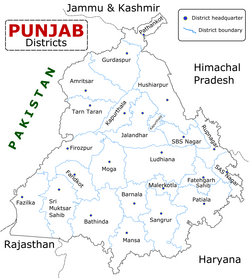
Moga district, which occupies 2,216 square kilometres, is divided into two tehsils, two sub-tehsils, and four community development blocks.[20][7] The two tehsils are: Bagha Purana and Nihal Singh Wala tehsils.[7] The two sub-tehsils are: Badhni Kalan and Dharamkot sub-tehsils.[7] According to the 2011 district census handbook for Moga district, there are three tehsils: Moga, Nihal Singhwala, and Bagha Purana tehsils.[11]:3
Moga city is the headquarters of the district.[20] The district contains around three towns and 180 villages.[20] Moga is bordered by Ferozepur district to the north, Ludhiana district to the east, Sangrur district to the southeast, Bathinda district to the south, and Faridkot district to the west.[20][7] Moga district is interconnected through roadways and railways to its neighbouring districts.[20] A railway connects Ferozepur, Moga, and Ludhiana districts together.[20] Moga district itself is part of the Firozpur division.[7]
Bagha Purana lies on the main road connecting Moga and Faridkot and thus is a major hub for buses to all across Punjab.[citation needed] Bagha Purana's police station has the largest jurisdiction in Punjab; over 65 'pinds' or villages are within its control.[citation needed] The town is basically divided into 3 'pattis' or sections: Muglu Patti (the biggest one), Bagha Patti, and Purana Patti.[citation needed] The town has its fair share of rich people and thus the standard of living is above average as compared to the surrounding towns and villages.[citation needed]
Punjabi cultural performance by students held at Panjab University Constituent College in Patto Hira Singh, Nihal Singh Wala tehsil, Moga district, Punjab, India, 18 October 2016
Many historical gurdwaras associated with the Sikh gurus can be found in Moga district.[20] There are gurdwaras associated with Guru Hargobind, Guru Har Rai, and Guru Gobind Singh, to be found in the district.[20] There is a Punjabi folk shrine dedicated to the folk deity Lakhdata in Langiana village in Moga district.[104] Shrines dedicated to Lakhdata are known as nigaha.[105] A dhuna dedicated to Sri Chand can be found in Korewal village in Daroli Baike in Moga district, which as per oral tradition was established by a roaming sadhu.[106]
In the 2001 census, Moga had a population of 886,313.[20] According to the 2011 census Moga district has a population of 995,746,[108] roughly equal to the nation of Fiji[109] or the US state of Montana.[110] This gives it a ranking of 447th in India (out of a total of 640).[108] The district has a population density of 444 inhabitants per square kilometre (1,150/sqmi) .[108] Its population growth rate over the decade 2001-2011 was 10.9%.[108] Moga has a sex ratio of 893 females for every 1000 males,[108] and a literacy rate of 71.6%. Scheduled Castes made up 36.50% of the population.[108]
Gender
The table below shows the sex ratio of Moga district through decades.
The district has the second highest percentage of Sikhs by district in Punjab, after Taran Taran (according to 2001 census).
The table below shows the population of different religions in absolute numbers in the urban and rural areas of Moga district.[115]
Absolute numbers of different religious groups in Moga district[115]
Religion
Urban (2011)
Rural (2011)
Urban (2001)
Rural (2001)
Sikh
1,20,975
6,97,946
98,934
6,68,835
Hindu
1,00,170
58,244
76,916
40,870
Muslim
1,874
7,514
968
5,028
Christian
1,844
1,433
1,501
1,063
Other religions
2,383
3,363
321
420
Economy
Old Grain Market in Moga, Punjab
The income of Municipalities and Municipal corporations in Moga district from municipal rates and taxes in the year 2018 was 577,781 thousand rupees.[116] Much of the economic development of the district is attributed to the Nestlé factory, with an industrial cluster forming to support the dairy industry, consisting of competing dairy farms and factories.[4] Nestlé purchases dairy from over 75,000 local farmers in the district, collecting twice a day from more than 650 village dairies.[4] In 2012, the Nestlé factory directly employed around 2,400 people, with a further 86,371 people being provided employment through Nestlé's main suppliers.[117]
Agriculture
An old man taking grass on cart for cattle in Gholia Kalan village, Moga district, Punjab, India, 29 October 2017
The local economy of Moga is dominated by the agricultural sector, with 90% of the land of the district being considered agricultural land.[20] The main staples of crop grown in Moga's farms are wheat, cumin, maize, barley, and millet.[20] Cotton, oilseeds, and potatoes are also cultivated, to a lesser extent.[20] The district exports much of the food-grains grown in it.[20] The grain markets of Moga are prominent, where surplus stocks of wheat, rice, pulses, oil-seeds, and cotton, are on sale.[20]
The main kind of livestock kept in Moga are cows, buffalos, bullocks, horses, mules, sheep, and goats.[20] The district contains a cattle hospital.[20]
Industry
Many factories in the state are for making agricultural-related products, nut-bolts, mustard-oil, engine-oil, coffee, condensed-milk, and footwear.[20] The district contains a Nestlé factory.[20] The Nestlé factory produces milk, milk-products, and maggi.[20] A surge of foreign-exchange coming into the district is related to the exporting of products such as motor-parts, cotton-seeds, oil-seeds, and nuts to international markets, such as Russia, the United Kingdom, the United States, Malaysia, Thailand, Poland, and others.[20]
In 2010-11, there were 2,850 registered Micro and Small Enterprise (MSE) units in Moga district, which provided employment to 21,218 people. There were 5 registered Medium and Large industrial units, which provided employment to 1,699 people.[118]
Politics
In 1952, before the delimitation exercise, Moga existed back then as Moga-Dharamkot constituency, which was represented by two candidates, Rattan Singh (Congress) and Devinder Singh (Akali Dal).[83] Moga tends to vote against the general trend.[83] In the last 14 elections that Moga assembly constituency had witnessed since 1952, the voters voted for the losing candidate at 12 elections.[83] It was only twice that the winning candidate from here belonged to the ruling party, with those candidates namely being Malti Thapar (Congress) in 1992 and Tota Singh of the Shiromani Akali Dal (SAD) in 1997.[83] Voters in the region do not generally vote based upon caste or religion.[83] Of the last fourteen MLAs, nine were Sikhs, with the remaining being Hindus: Sathi Rup Lal, Malti Thapar, and Joginderpal Jain.[83] The secular nature of the voters in the region has been attributed to the numerous social and political movements that occurred in Moga over the years.[83] On different occasions, the Akali Dal has launched their political campaigns from Moga before going for the assembly polls, such as in 1996, 2006, and 2011, before returning to power.[83][119] Moga has been described as a key place in Punjabi politics.[119] All three majors parties, SAD, Congress, and the AAP, place importance on starting their political rallies from Moga.[119] In September 2016, the Aam Aadmi Party (AAP) released their manifesto at a political rally for farmers at Bagha Purana.[119]
Government Senior Secondary School in Mahla Kalan village, Moga district, Punjab
Moga city is also known for its advanced number of educational institutes, such as middle, high, and senior secondary schools, colleges, and libraries.[20] The district also contains Ayurvedic colleges.[20] The district has two public libraries which contain reading-room facilities.[20]
According to a 2009–10 survey, around 32 sq km of the district is classified as state forest.[11]:7–8 Tree-species found in the district include: Shisham, Kikar, Mango, Tut, Jamun, Serin, Neem, Dak/Darek, Pipal, Eucalyptus, andBeriand Khajur.[11]:7–8 In water-logged areas, the following species can be found: Kana, Kahi, Arjun, Dale, and Battar.[11]:7–8
Photograph of birds sitting on an old well at Dhurkot village, Nihal Singh Wala tehsil, Moga district, Punjab, India, 5 September 2017
The district currently has a low amount of its area under forest cover, partly due to past deforestation during the Green Revolution,[120] but afforestation and reforestation drives have led to the planting of saplings in the district.[121] 9 million tree saplings are planned to be planted in the district before 2026 by NITI Aayog to meet the demands of a World Economic Forum initiative, with hopes of increasing Moga district's percentage of land under forest cover from the current 1.25% (2,575 hectares) to over 5% (11, 575 hectares).[121] In September 2021, a garden, named 'Guru Granth Sahib Bagh', was set-up in the historical village of Patto Hira Singh in the district. The garden is notable as it contains flora species mentioned in the Guru Granth Sahib, the primary Sikh canonical scripture and is intended on highlighting the connection between the Sikh Gurus and the natural world.[122]
Health
Many ayurvedic and allopathic health facilities, such as dispensaries and hospitals, can be found in the district.[20] There are also regular hospitals and family-planning centres.[20]
The table below shows the data from the district nutrition profile of children below the age of 5 years, in Moga, as of year 2020.
District nutrition profile of children under 5 years of age in Moga, year 2020 [123]
Indicators
Number of children (<5 years)
Percentage
Stunted
16,207
22%
Wasted
8,818
12%
Severely wasted
2,245
3%
Underweight
12,365
17%
Overweight/obesity
3,606
5%
Anemia
46,467
70%
Total children
73,602
The table below shows the district nutrition profile of Moga of women between the ages of 15 and 49 years, as of year 2020.
District nutritional profile of Moga of women of 15–49 years, in 2020[123]
Indicators
Number of women (15–49 years)
Percentage
Underweight (BMI <18.5kg/m^2)
41,329
13%
Overweight/obesity
101,378
33%
Hypertension
95,952
31%
Diabetes
45,699
15%
Anemia (non-preg)
168,240
55%
Total women (preg)
15,808
Total women
307,737
The table below shows the current use of family planning methods by currently married women between the age of 15 and 49 years, in Moga district.
Family planning methods used by women between the ages of 15 and 49 years, in Moga district[124][125]
Method
Total (2019–21)
Total (2015–16)
Rural (2015–16)
Female sterilization
25.6%
37.5%
38.9%
Male sterilization
0.6%
0.2%
0.2%
IUD/PPIUD
3.2%
5.6%
4.8%
Pill
1.9%
2.6%
2.2%
Condom
28.2%
21.1%
20.0%
Injectables
0.0%
0.6%
--
Any modern method
60.0%
67.4%
66.4%
Any method
75.0%
76.6%
74.2%
Total unmet need
8.0%
6.4%
7.4%
Unmet need for spacing
2.7%
2.2%
2.7%
The table below shows the number of road accidents and people affected in Moga district by year.
Road accidents and people affected in Moga district by year[126]
Year
Accidents
Killed
Injured
Vehicles Involved
2022
220
201
64
158
2021
193
185
95
181
2020
185
173
70
142
2019
135
110
92
145
Deputy Commissioners
Moga district have following Deputy Commissioners so far:[127]
#
Name
Assumed office
Left office
Tenure
1
Phulwant Singh Sidhu
5 December 1995
4 December 1996
365days
2
Cap. Narinder Singh
4 December 1996
18 February 1997
76days
3
R Venkatraman
18 February 1997
28 April 1998
1year, 69days
4
K.S. Kang
28 April 1998
3 June 1999
1year, 36days
5
K.B.S Sidhu
3 June 1999
4 March 2002
2years, 274days
6
G. Raman Kumar
4 March 2002
25 July 2004
2years, 143days
7
Mandeep Singh
26 July 2004
6 April 2006
1year, 254days
8
V.K. Meena
7 April 2006
9 October 2006
185days
9
Arvinder Singh
9 October 2006
23 December 2006
75days
10
S.K. Sharma
23 December 2006
12 March 2007
365days
11
Arvinder Singh
12 March 2007
6 November 2007
239days
12
Satwant Singh
7 November 2007
11 August 2010
2years, 277days
13
Vijay N. Zade
11 August 2010
28 July 2011
351days
14
Ashok Kumar Singla
28 July 2011
28 December 2011
153days
15
B. Purushertha
28 December 2011
3 April 2012
97days
16
Arshdeep Singh Thind
3 April 2012
30 May 2014
2years, 57days
17
Parminder Singh Gill
2 June 2014
5 January 2016
1year, 217days
18
Kuldeep Singh Vaid
3 February 2016
30 November 2016
301days
19
Parminder Singh Gill
9 December 2016
5 January 2017
27days
20
Parveen Kumar Thind
6 January 2017
15 May 2017
129days
21
Dilraj Singh
16 May 2017
29 August 2018
1year, 105days
22
Devinderpal Singh Kharbanda
29 August 2018
2 October 2018
34days
23
Sandeep Hans
3 October 2018
5 October 2021
3years, 2days
24
Dr. Harish Nayar
5 October 2021
1 April 2022
178days
25
Kulwant Singh
3 April 2022
16 August 2024
2years, 135days
26
Vishesh Sarangal
17 August 2024
Till Date
1year, 166days
Land and genealogical records
Example of a genealogical pedigree (family-tree) of a landowning family of Chugawan village in Moga district (formerly part of Ferozepore district), Punjab, 1887–1888
Shajjra Nasb (also known as Kursee Nama[note 8]) records of villages of Moga district from 1887–1958 have been digitized by the Church of Jesus Christ of Latter-day Saints via FamilySearch and are available for online viewing.[128] These records detail land ownership pedigrees for families of the village.[129][130] The genealogical importance of such records for the purpose of family history research was raised by Gurcharan Singh Gill of Moga.[131][132] Gill discovered in 1986 that tax-records in the district were attached to a genealogical pedigree going back four generations, with records dating back to the 1850's.[131][132] These records have been described as being one of the few surviving records of Punjabi genealogy, as census records in India were rarely preserved.[131] The more recent records were written in Punjabi using Gurmukhi script and the older records were written in Urdu in Nastaliq script.[131] The names of more than 250,000 individuals have been extracted from the records by Gill.[131]
Jaswant Singh Kanwal, Sahitya academic fellowship for the book 'Pakhi' 1996 and Sahitya Akademi award for 'Taushali Di Hanso' 1998. He was from Dhudike vill.
123"Section 2: Different Districts of Punjab – Moga District". Discover Punjab: Attractions of Punjab. Parminder Singh Grover Moga, Davinderjit Singh, Bhupinder Singh. Ludhiana, Punjab, India: Golden Point Pvt Ltd. 2011. Moga district is one of the nineteen districts in the state of Punjab in North West Republic of India. It became the 17th district of Punjab State on 24 November 1995. It is also known as NRI district. Most Punjabi Non-resident Indians (NRIs) belong to rural areas of Moga District, who immigrated to the USA, the UK and Canada in the last 30-40 years. 40-45% of the population of NRIs from Canada, the US and the UK belong to Moga district. Moga District is among the largest producers of wheat and rice in Punjab, India. People from Moga City and Moga District belong to the Malwa culture. Numerous attempts were previously made to make Moga a district but all were unsuccessful. Finally the then Chief Minister of Punjab S. Harcharan Singh Brar agreed to the public demand to make this a district on 24 November 1995. Before this, Moga was the subdivision of Faridkot district. Moga town, the headquarters of the district, is situated on Ferozpur-Ludhiana road.{{cite book}}: CS1 maint: others (link)
1234567891011121314151617Moon, Hwy-Chang (9 August 2018). "7.5: Business Case: Nestlé's CSV Activities in India". The Art of Strategy: Sun Tzu, Michael Porter, and Beyond. Cambridge University Press. pp.159–162. ISBN9781108470308.
↑Mārg̲. Vol.37. Marg Publications. 1983. p.22. A copperplate inscription from Taxila speaks of 'the Great King, the Great Moga.' Moga is the Indianised form of Maues . Does the city of Moga in Punjab enshrine his name?
1234567891011Khokhar, Gurdip Kaur, ed. (2010). "II - History". Punjab District Gazetteers: Moga(PDF). Chandigarh, India: Revenue and Rehabilitation Department, Government of Punjab. pp.15–37.
↑Frontiers of the Indus civilization: Sir Mortimer Wheeler commemoration volume. Mortimer Wheeler, B. B. Lal, S. P. Gupta. New Delhi: Published by Books & Books on behalf of Indian Archaeological Society jointly with Indian History & Culture Society. 1984. ISBN0-85672-231-6. OCLC11915695.{{cite book}}: CS1 maint: others (link)
↑Asher, Catherine B. (2006). India before Europe. Cynthia Talbot. New York: Cambridge University Press. ISBN0-521-80904-5. OCLC61303480.
↑Nomads in the sedentary world. Anatoly M. Khazanov, André. Wink. London: Routledge. 2001. ISBN978-0-203-03720-1. OCLC820853396. Hiuen Tsang gave the following account of a numerous pastoral-nomadic population in seventh-century Sin-ti (Sind): 'By the side of the river..[of Sind], along the flat marshy lowlands for some thousand li, there are several hundreds of thousands [a very great many] families ..[which] give themselves exclusively to tending cattle and from this derive their livelihood. They have no masters, and whether men or women, have neither rich nor poor.' While they were left unnamed by the Chinese pilgrim, these same people of lower Sind were called Jats' or 'Jats of the wastes' by the Arab geographers. The Jats, as 'dromedary men.' were one of the chief pastoral-nomadic divisions at that time, with numerous subdivisions, ....{{cite book}}: CS1 maint: others (link)
↑Wink, André (2004). Indo-Islamic society: 14th – 15th centuries. BRILL. pp.92–93. ISBN978-90-04-13561-1. In Sind, the breeding and grazing of sheep and buffaloes was the regular occupations of pastoral nomads in the lower country of the south, while the breeding of goats and camels was the dominant activity in the regions immediately to the east of the Kirthar range and between Multan and Mansura. The jats were one of the chief pastoral-nomadic divisions here in early-medieval times, and although some of these migrated as far as Iraq, they generally did not move over very long distances on a regular basis. Many jats migrated to the north, into the Panjab, and here, between the eleventh and sixteenth centuries, the once largely pastoral-nomadic Jat population was transformed into sedentary peasants. Some Jats continued to live in the thinly populated barr country between the five rivers of the Panjab, adopting a kind of transhumance, based on the herding of goats and camels. It seems that what happened to the jats is paradigmatic of most other pastoral and pastoral-nomadic populations in India in the sense that they became ever more closed in by an expanding sedentary-agricultural realm.
↑Dalal, Sukhvir Singh (April 2013). "Jat Jyoti". Jat Jyoti. Jat Biographical Centre B-49, First Floor, Church Road, Joshi Colony, I. P. Extension Delhi 110092: Jat Biographical Centre: 7.{{cite journal}}: CS1 maint: location (link)
12Singha, H.S. (2000). The Encyclopedia of Sikhism (Over 1000 Entries). Hemkunt Press. p.194. ISBN9788170103011. 1. Tambu Sahib, Dagru: It is situated in village Dagru near Moga and is dedicated to Guru Har Rai who encamped here in the course of his journey through the Malwa region.
12345Singh, Harbans. The Encyclopedia of Sikhism. Vol.I: A-D. Punjabi University, Patiala. pp.484–485.
12Fenech, Louis E. (2013). The Sikh Zafar-namah of Guru Gobind Singh: A Discursive Blade in the Heart of the Mughal Empire. Oxford University Press. pp.24–25. ISBN9780199931439.
↑Singh, Bhagat (1993). A History of the Sikh Misals. Publication Bureau, Punjabi University. pp.259–261.
↑Gupta, Hari Ram (1999). History of The Sikhs: The Sikh Commonwealth or Rise and Fall of Sikh Misls. Vol.4. Munshiram Manoharlal Publishers. p.206. ISBN9788121501651.
12Gandhi, Surjit Singh (1999). Sikhs in the Eighteenth Century: Their Struggle for Survival. Singh Bros. p.533. ISBN9788172052171. Tara Singh Ghaiba, a prominent leader of the Dallewalia Misl, extended his conquests as far as Ramuwala and Mari in the Moga tahsil at both of which places he built forts.
↑Gupta, Hari Ram (1978). History of the Sikhs: The Sikh Lion of Lahore, Maharaja Ranjit Singh, 1799-1839. Vol.5 (3rded.). Munshiram Manoharlal. p.51. ISBN9788121505154.
12Bansal, Bobby Singh (1 December 2015). Remnants of the Sikh Empire: Historical Sikh Monuments in India & Pakistan. Hay House. ISBN9789384544935. Sada Kaur, held vast estates in Batala and Mukerian, yet her extensive jagirs were also located in the cis-Sutlej territories at Wadhni, about 20km south of present day Moga town in Moga district. The ancestral fort of Sada Kaur had been demolished some forty years ago and the nanak-shahi bricks divided amongst her descendants. From all accounts it was a grand structure with magnificent arches and balconies. The wooden carved gates were equally impressive which required about 25 men to lift a single panel. A Sikh temple and a statue now stands in place of the fort in the memory of the gallant Sada Kaur who died incarceration at Amritsar in 1832 ...
↑Gupta, Hari Ram (1991). History of the Sikhs. Vol.5. Munshiram Manoharlal. pp.87–88. ISBN9788121505154.
↑Historical Dictionary of Sikhism. Louis E. Fenech, W. H. McLeod (3rded.). Rowman & Littlefield. 11 June 2014. p.171. ISBN9781442236011.{{cite book}}: CS1 maint: others (link)
↑page no. 2- DISTRICT GAZETTEER, FEROZEPUR DISTRICT, 1915Access here
↑page no. 34, 40, 41- DISTRICT GAZETTEER, FEROZEPUR DISTRICT, 1915Access here
↑Punjab Government Records, Mutiny Reports. Vol.VIII. pp.Pt.I, pp. 47–57, pt.II, pp. 208–210, 331.
123Grewal, J. S. (March 2018). Master Tara Singh in Indian History: Colonialism, Nationalism, and the Politics of Sikh Identity (Onlineed.). Oxford University Press. ISBN9780199089840.
↑Mangat, Devinder Singh (11 February 2023). A Brief History of the Sikhs (Multidimensional Sikh Struggles). SLM Publishers. p.300. ISBN9789391083403. Education being their primary goal for positive human progress, the Samaj opened its first co-educational school at Moga in 1899. The same school later on was promoted to be Dev Samaj High School. Dev Samaj Managing Council is still running same prestigious institutions in Ferozpur, Moga, Ambala, Delhi and Chandigarh.
12Social History of Epidemics in the Colonial Punjab. Sasha. Partridge Publishing. 28 August 2014. p.129. ISBN9781482836226. The Tribune reported that during the plague epidemic of 1901, there were insufficient number of huts in Hudiabad, Zaffarwal, Moga and villages of Ali Mardan and Gundial. In Moga, the residents from both the infected and uninfected localities were asked to move into the camps and thus increase the risk of spread of the infection.{{cite book}}: CS1 maint: others (link)
↑Religion and Society. Vol.38. Christian Institute for the Study of Religion and Society. 1991. p.21. ... history of the Punjab Mission is Rev. John Hyde popularly known as praying Hyde. He came to India in 1894 and worked mainly in the area of Ferozepore and Moga. He was instrumental in starting a Punjab Prayer Union ...
1234Windel, Aaron (30 November 2021). Cooperative Rule: Community Development in Britain's Late Empire. University of California Press. p.69. ISBN9780520381896.
12Harper, Irene Mason (February 1932). Pierson, Delavan Leonard (ed.). "Modern Miracles at Moga". The Missionary Review of the World. 55: 83–87.
12Webster, John C. B. (22 December 2018). A Social History of Christianity: North-west India since 1800. Oxford University Press. ISBN9780199097579. However, the most radical experiment in rural education was the Training School for Village Teachers at Moga. Begun in 1908, it became a middle school in 1917 and added a two-year teacher's training course in 1923. William McKee introduced the 'project method' of education in 1919. Each boy was given a small plot of land to cultivate; he could sell its produce to help pay his school expenses and earn spending money. He thus had a strong incentive to learn not only improved methods of agriculture but also arithmetic and basic accounting! In addition, each class had a special project (for example, the village home, the village farm, the village bazar, etc.) around which learning for the year would be organized and through participation in which the boys acquired some additional skills, came to understand their immediate environment, and learned to work together for the common good. This approach to education was applied to religious education as well. As Irene Harper, who taught at Moga for many years, pointed out, Moga's influence was considerable, as it was seen, both inside and beyond the Punjab, as a model for educating the rural poor. Between 1922 and 1926, eighty- eight of their ninety-six candidates in the teacher training course became teachers, seventy-five in village day or boarding schools. Moga not only continued to supervise them after they graduated but also published The Village Teacher's Journal which was translated into five languages.
12Agricultural History. Vol.42. Agricultural History Society. 1968. pp.30–32.
↑Harper, Tim (12 January 2021). Underground Asia: Global Revolutionaries and the Assault on Empire. Harvard University Press. p.222. ISBN9780674724617. Much of the initial action was uncoordinated. In November 1914 there were attempts to recruit the 23rd Cavalry stationed at Lahore, and a raid took place on a treasury at Moga in which two officials were shot dead.
↑Prasad, Ritika (12 May 2016). Tracks of Change. Cambridge University Press. p.247. ISBN9781107084216. Similarly, the Commissioner of Jullunder reported how in Ferozepore district a crowd returning from a meeting in March 1921 refused to present their tickets to the station-master when they alighted from the train at Moga. Instead, they kept shouting 'Mahatma Gandhi ki jai, ticket nahin hai' (Hail Mahatma Gandhi, we have no ticket). Responding to this, the station-master opened the platform gate, reportedly saying 'Phatak khula hai' (the gate is open).
↑Harper, A. E., ed. (1944). The Moga Journal for Teachers. 24: 31.{{cite journal}}: Missing or empty |title= (help)
↑Nevile, Pran (2006). "A Miracle Medicine and Sex Manuals". Lahore: A Sentimental Journey. Penguin Books India. pp.14–15. ISBN9780143061977.
↑Dodd, Edward Mills (1964). The Gift of the Healer: The Story of Men and Medicine in the Overseas Mission of the Church. Friendship Press. p.94.
↑Gandhi, Mohandas Karamchand (1979). The Collected Works of Mahatma Gandhi. Vol.75. Publications Division, Ministry of Information and Broadcasting, Government of India. p.326.
↑Darling, Malcolm (1934). Wisdom and Waste in the Punjab Village. Oxford University Press. p.107.
123456Mukherjee, Mridula (22 September 2004). Peasants in India's Non-Violent Revolution: Practice and Theory. SAGE. ISBN9780761996866.
1234Chatterji, Basudev (1999). Towards Freedom: Documents on the Movement for Independence in India, 1938, Part 3. Indian Council of Historical Research. pp.3545, 3548, 3552. ISBN9780195644494.
↑Jalal, Ayesha (2000). Self and Sovereignty: Individual and Community in South Asian Islam Since 1850. Psychology Press. p.536. ISBN9780415220774.
↑Madhok, Balraj (1985). Punjab Problem: the Muslim Connection. Hindu World Publications. p.95. ISBN9780836415193. There were only two tehsils or sub-divisions - Moga and Taran Taran - in the whole of Punjab which had a slight Sikh majority.
12Khan, Yasmin (1 January 2007). The Great Partition: The Making of India and Pakistan. Yale University Press. p.107. ISBN9780300120783.
123456789101112Bajwa, K. S. “A CRITICAL APPRAISAL OF DIARY OF ANOKH SINGH ON THE PARTITION OF INDIA 1947.” Proceedings of the Indian History Congress, vol. 72, 2011, pp. 1337–43. JSTOR, http://www.jstor.org/stable/44145744. Accessed 19 Dec. 2024.
↑Atkins, Robert (30 December 2021). The Gurkha Diaries of Robert Atkins MC: India and Malaya 1944 - 1958. Pen and Sword Military. p.22. ISBN9781399091480. This part of the Punjab was mainly Sikh, but there were many Punjabi Muslims as well. Most of these people were murdered, although they had previously been living together in the villages in harmony. Soon after I arrived I went to Moga, where there had been a massacre. There were dead and mutilated bodies all over the place which made me feel sick. However, it was a sight one soon got used to; in fact, one became completely hardened to these horrific sights - even rather callous.
↑Tanwar, Raghuvendra (2006). Reporting the Partition of Punjab, 1947: Press, Public, and Other Opinions. Manohar. p.342. ISBN9788173046742. Heavy loss of life and property was reported from Jullundur, Gujranwala, Quetta, and Moga.
↑Page No. 160- Feropzur District Census Handbook 1961, Punjab (India) Access here
↑Rural Labour Relations in India. T.J. Byres, Karin Kapadia, Jens Lerche. Routledge. 18 October 2013. p.66. ISBN9781135299460.{{cite book}}: CS1 maint: others (link)
↑Seshagiri, Narasimhiah, ed. (2008). "Moga". Encyclopaedia of Cities and Towns in India: Punjab. Vol.3. Gyan Publishing House. pp.294–295. ISBN9788121209731.
↑Documents of the Ninth Congress of the Communist Party of India. Communist Party publication. Vol.9. Congress of the Communist Party of India. 1971. pp.157, 306, 310.
↑Singh, Gurharpal (1994). Communism in Punjab: a study of the movement up to 1967. Delhi: Ajanta Publications. p.245. ISBN81-202-0403-4. OCLC30511796.
↑Party Life. Vol.23. Communist Party of India. 1987. p.15. The Faridkot jatha toured the Moga sub - division for four days and went through some of the worst disturbed areas
↑Judge, Paramjit S. (1992). Insurrection to agitation: the Naxalite Movement in Punjab. Bombay: Popular Prakashan. pp.133–138. ISBN81-7154-527-0. OCLC28372585.
↑Basu, Jyoti (1997). Documents of the Communist Movement in India: 1989-1991. Vol.23. Calcutta: National Book Agency. p.53. ISBN81-7626-000-2. OCLC38602806.
12Martyrdom of Shaheed Bhagat Singh. Kulwant Singh Kooner, Gurpreet Singh Sindhra. Unistar Books. 5 February 2013. p.10. ISBN978-9351130611. ... Punjab was in turmoil due to student's agitation known as "Moga-Regal Cinema Movement" ...{{cite book}}: CS1 maint: others (link)
12The Punjab Story. Amarjit Kaur, Lt Gen Jagjit Singh Aurora, Khushwant Singh, MV Kamanth, Shekhar Gupta, Subhash Kirpekar, Sunil Sethi, Tavleen Singh. Roli Books. 10 August 2012. His [Bhindranwale's] favourite story, for example, of atrocities committed upon Sikhs by Hindus was the instance of a village near Moga where the Hindus had ganged up against a Sikh girl. 'She was harassed and then beaten; he said, 'and then in full public view stripped naked. As if that was not enough, they (the Hindus) forced her father to have intercourse with her.' I heard him tell this story at least three times. ... But when asked to furnish details of the name of the family, village, etc., Bhindranwale turned evasive and belligerent.{{cite book}}: CS1 maint: others (link)
↑Amritsar: Mrs Gandhi's Last Battle. Mark Tully, Satish Jacob. J. Cape. 1985. p.140. ISBN9780224023283.{{cite book}}: CS1 maint: others (link)
12Bhattacharya, Samir (2014). NOTHING BUT!. Vol.4: Love Has No Religion. Partridge Publishing. p.568. ISBN9781482817201. A month earlier on getting the news that some militants had taken refuge inside the gurdwara at Moga, near Ludhiana, the government had ordered the paramilitary battalion from the BSF, the Border Security Force to lay a siege to it and not to lift it under any circumstances till the militants surrendered. But after five days into the siege when the high priests of the Golden Temple threatened that they would lead a march on Moga if the siege was not lifted, the government it seems meekly caved in. They feared that the siege would only fuel the fire in the countryside and they could not afford to antagonize the common people anymore.
↑Pettigrew, Joyce (27 April 1995). The Sikhs of the Punjab: Unheard Voices of State and Guerilla Violence. Bloomsbury Academic. pp.18–20. ISBN9781856493550.
↑Singh, Kuldip (31 October 2024). Punjab River Waters Dispute in South Asia: Historical Legacies, Political Competition, and Peasant Interests. Taylor & Francis. ISBN9781040273753. The tendencies toward moderation were clearly visible toward the end of 1994 when the Akal Takht Jathedar issued directive to various Akali factions to merge into one party. The Badal faction decided to remain away because the other Akali factions, which eventually merged into Akali Dal Amritsar clearly had a secessionist agenda. From then on, the Akali Dal Badal was on a new path of moderate politics, which could also be read through its Moga Declaration of 1996.
↑Sullivan, Bruce M. (22 October 2015). "Sikh Museuming". Sacred Objects in Secular Spaces: Exhibiting Asian Religions in Museums. Bloomsbury Publishing. p.62. ISBN9781472590831. There is controversy associated with relics that travel; the Shiromani Gurdwara Prabhandak Committee (SGPC), which governs Sikh gurdwaras in Punjab and is both religiously and politically powerful, planned to reprimand and demand penance from Gursewak Singh Sodhi of Dhilwana Kalan village, in the Moga district of the Indian Punjab, for sending relics consisting of the clothes and turban of Guru Gobind Singh to Canada from a shrine there without its permission in 2003. The SGPC claimed that this had "really hurt" the sentiments of India's Sikh community ...
↑Jaglan, Mahabir S. (30 September 2024). "6: Protest-landscape of the farmers' movement in Haryana". In Singh, Shamsher; Siddiqui, Sabah (eds.). A People's History of the Farmers' Movement, 2020–2021. Rajeshwari. Taylor & Francis. pp.84–106. doi:10.4324/9781003496625-6. ISBN9781040122679. It was here in Moga the seeds of the forthcoming pan-India farmers' agitation were sown when 32 farmer unions decided to begin a collective struggle against the new farm laws (Times News Network, 2021). They carried out an about two-month agitation in Punjab between September and November 2020.
123Prill, Susan E. (27 March 2014). "19. Ecotheology". In Singh, Pashaura; Fenech, Louis E. (eds.). The Oxford Handbook of Sikh Studies. Oxford University Press. pp.223–234. ISBN9780191004117.
↑Singh, Karan (12 May 2023). "Baba Lakhdata/Pir Nigaha/Shakhi Sarwar". Syncretic Shrines and Pilgrimages: Dynamics of Indian Nationalism. Taylor & Francis. ISBN9781000880038. Baba Lakhdata/Pir Nigaha/Shakhi Sarwar has two shrines in India: In village Langiana, district Moga, Punjab, and village Basoli, district Una, Himachal Pradesh.
↑Chaudhuri, Supriya (19 August 2021). "Memorializing Sakhi Sarwar, Baba Farid, and Sabir Pak". Religion and the City in India. Routledge. ISBN9781000429015. Post-Partition, two important Sakhi Sarwar shrines (Nigaha) are located in Una in Himachal Pradesh and Moga in Indian Punjab.
↑Singh, Joginder (22 August 2017). "Dhuna of Baba Sri Chand Korewal (Moga)". Religious Pluralism in Punjab: A Contemporary Account of Sikh Sants, Babas, Gurus and Satgurus. Routledge. ISBN9781351986342.
This page is based on this Wikipedia article Text is available under the CC BY-SA 4.0 license; additional terms may apply. Images, videos and audio are available under their respective licenses.