Pathankot district

Last updated

Pathankot district
Dhar Kalan, Pathankot view.jpg
Dhar Kalan, Pathankot - The Mini Goa of Punjab
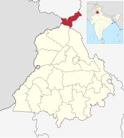
Pathankot in Punjab (India).svg
Location in Punjab
Coordinates: 32°16′01″N75°38′36″E / 32.266814°N 75.643444°E / 32.266814; 75.643444
CountryFlag of India.svg  India
State Punjab
Named for Pathania Rajput
Headquarters Pathankot
Government
   Deputy commissioner Sh. Ramveer
   Senior Superintendent of Police R.K. Bakshi (PPS)
   Member of Parliament Sunny Deol
Area
[1]
  Total929 km2 (359 sq mi)
Population
 (2011) [1]
  Total676,598
  Density730/km2 (1,900/sq mi)
Languages
  Regional Punjabi, Hindi, English
Time zone UTC+5:30 (IST)
Vehicle registration PB-35 / PB-68
Largest City Pathankot
Website https://pathankot.nic.in

Pathankot district is the northernmost district of the Indian state of Punjab. Pathankot is the district headquarters. The district was formed on July 27, 2011.

Contents

Etymology

The original name of Pathankot was Paithan during Mughal times, which is in turn believed to be a derivative of Sanskrit Pratisthana [[ later Paithan was retrieved again by Chandravanshi Rajput clan Pathania “meaning No Pathans” and named Pathankot ]] [2] .The suffix 'kot' stands for fort.

Geography

The Ravi river at Pathankot Ravi River at Pathankot.jpg
The Ravi river at Pathankot

Pathankot is located in the foothills of the Sivalik Hills. It shares international borders with the Narowal District of Pakistan's Punjab. It also shares borders with the Kathua District of Jammu and Kashmir and the Chamba and Kangra districts of Himachal Pradesh. Hoshiarpur district shares a boundary with Pathankot in Eastern Punjab. The two main rivers, – the Beas and the Ravi, pass through the district.

The district today

Ranjit Sagar dam over the Ravi river Ranjit Sagar Dam 1.jpg
Ranjit Sagar dam over the Ravi river

In the past, It was a Tehsil of the district of Gurdaspur. The present district was formed, as the 22nd district of the state on July 27, 2011. [3] [4] Pathankot includes the two sub-divisions of Pathankot and Dhar Kalan and the two sub-tehsil of Narot Jaimal Singh and Bamial [4]

Pathankot has gone through a large number of changes and developments. It is also called as the gateway to Himachal Pradesh and J&K states. Ranjit Sagar Dam, the Pride of Punjab, has been emerged about 30 km. north-east of the town. Mamoon, a suburb of Pathankot, is heading towards the biggest army cantonment in Asia. Pathankot already has an Air Force Station and will be coming on the air map of India very shortly. Surprisingly enough, the town is totally devoid of any monumental evidence to speak of its rich past except for a high ridge called Shimla Pahari, where the historical fort once existed, and some part of the rouni around the Gulmohar Tourist Complex. A number of various buildings, such as the PWD Rest House. Gulmohar Tourist Complex, Maharaja Ranjit Singh Municipal Library, Lal Bahadur Shastri Park, the Relay center of Doordarshan, and an office of the central PWD are located at the site of the Fort.

City and towns

There are two statutory Cities Pathankot and Sujanpur in this district. The district also has 12 census towns, according to census 2011 which are listed below: [5]

Other villages and settlements

Demographics

At the time of the 2011 census, the area that would become Pathankot district had a population of 676,598. Out of these 378,432 were rural and 298,166 urban. Pathankot has a sex ratio of 860 females per 1000 males. Scheduled Castes are 207,032 (30.60%) of the population. [6]

Religion in Pathankot district (2011) [7]
ReligionPercent
Hinduism
88.42%
Sikhism
7.81%
Islam
2.12%
Christianity
1.08%
Other or not stated
0.57%
Religion in Pathankot District [lower-alpha 1]
ReligionPopulation (1941) [8] :60–61Percentage (1941)Population (2011) [7] Percentage (2011)
Hinduism Om.svg [lower-alpha 2] 83,33054.42%598,23788.42%
Islam Star and Crescent.svg 59,54838.89%14,3172.12%
Sikhism Khanda.svg 7,5804.95%52,8587.81%
Christianity Christian cross.svg 2,3071.51%7,2921.08%
Others [lower-alpha 3] 3690.24%3,8940.57%
Total Population153,134676,598

At the time of the 2011 census, 89.86% of the population spoke Punjabi, 5.30% Hindi and 1.20% Dogri as their first language. [9] The dialect is in between Kangri and Dogri, the two neighbouring languages.

Languages of Pathankot (First Language) (2011) [9]

   Punjabi (89.86%)
   Hindi (5.30%)
   Dogri (1.20%)
  Others (3.64%)

Politics

Pathankot district is part of the Pathankot Assembly Constituency.

No.ConstituencyName of MLAPartyBench
1 Sujanpur Naresh Puri Indian National Congress Opposition
2 Bhoa (SC) Lal Chand Kataruchakk Aam Aadmi Party Government
3 Pathankot Ashwani Kumar Sharma Bharatiya Janata Party Opposition

Notable people

Related Research Articles

<span class="mw-page-title-main">Kangra district</span> District in Himachal Pradesh, India

Kangra district is the most populous district of the Indian state of Himachal Pradesh. Dharamshala is the administrative headquarters of the district.

<span class="mw-page-title-main">Hamirpur district, Himachal Pradesh</span> A district in Himachal Pradesh, India

Hamirpur district is in the Indian state of Himachal Pradesh. The headquarters of the district are in the town of Hamirpur. With an area of 1,118 square kilometres or 432 square miles, it is the smallest district of Himachal Pradesh.

<span class="mw-page-title-main">Mandi district</span> A district in Himachal Pradesh, India

Mandi district is one of the central districts of Himachal Pradesh state in northern India. The town of Mandi is the headquarters of the district.

<span class="mw-page-title-main">Gurdaspur district</span> District in Punjab, India

Gurdaspur district is a district in the Majha region of the state of Punjab, India. Gurdaspur is the district headquarters. It internationally borders Narowal District of Pakistani Punjab, and the districts of Amritsar, Pathankot, Kapurthala and Hoshiarpur. Two main rivers Beas and Ravi passes through the district. The Mughal emperor Akbar is said to have been enthroned in a garden near Kalanaur, a historically important town in the district. The district is at the foothills of the Himalayas.

<span class="mw-page-title-main">Pathankot</span> City in Punjab, India

Pathankot is a city and the district headquarters of the Pathankot district in Punjab, India. Pathankot is the 6th most populous city of Punjab, after Ludhiana, Amritsar, Jalandhar, Patiala and Bathinda. Its local government is a municipal corporation.

<span class="mw-page-title-main">Hamirpur, Himachal Pradesh</span> Town,Village in Himachal Pradesh, India

Hamirpur is a town, municipal council and the headquarters of Hamirpur district in the Indian state of Himachal Pradesh. It is covered by Shivalik Ranges. Hamirpur is located in the Lower West Central Outer Himalayas at an average elevation of 790 M above sea level. Far northern High Altitude Dhauladhar Ranges overlook the city. It is also a major junction on National Highway 3 while National Highway 103 starts at Here. Hamirpur is famous for its high literacy rate, educational institutions and traditional festival of Hamir Utsav. Hamirpur City is spread from Jhaniari to Bhota along NH 3 and NH 103 and is a prominent commercial centre for the district. It is Connected to the National Capital with regular HRTC Volvo and ordinary buses. The nearest airport is Kangra Airport and Mohali International Airport while the nearest railway is in Una at 79 km. Hamirpur City is surrounded by Pine tree forests and has a good city infrastructure ranging from quality educational institutions, NIT, State Universities and Skill Learning centres.

Kalanaur is a tehsil in Gurdaspur District of Punjab state in India. It is located 25 km towards west from District headquarters Gurdaspur. This historical town is situated on newly constructed National Highway 354. The town has historical significance as Mughal Emperor Akbar, was enthroned in a garden near the Kalanaur by Bairam Khan. It was first Established as a Principality by Prince Nakhashena, a brother of King Janamejaya. He Established the Principality which was further ruled by his descendants known as Jarral Rajputs. Jarral rule in Kalanaur lasted for 350 Years

<span class="mw-page-title-main">Shimla district</span> District of Himachal Pradesh in India

Shimla district is one of the twelve districts of the state of Himachal Pradesh in northern India. Its headquarters is the state capital of Shimla. Neighbouring districts are Mandi and Kullu in the north, Kinnaur in the east, Uttarakhand in the southeast, Solan to the southwest and Sirmaur in the south. The elevation of the district ranges from 987 metres (3,238 ft) to 4,500 metres (14,764 ft).

Fatehgarh Churian is a town located in Gurdaspur district in Punjab, India. It is nearby Gurdaspur city, the district headquarter. It is a municipal council of the Gurdaspur district. The city lies 15 kilometres from the Pakistani border. It is located 485 kilometres north of New Delhi, India.

<span class="mw-page-title-main">Tira Sujanpur</span> Town in Himachal Pradesh, India

Tira Sujanpur, also known as Sujanpur Tira or Sujanpur Tihra, is a town and municipal council in the Hamirpur district of Himachal Pradesh. Founded in the 18th century by the Katoch dynasty, the town is located midst the Himalayan foothills on the southern bank of the Beas River. It was one of the centers of Kangra-style miniature paintings and Hindu temples built in an unusual blend of conventional Nagara architecture shrines with Mughal architecture palace, the latter decorated with floral murals of legends from the Ramayana and the Mahabharata.

Madhopur is a town, located, near city of Pathankot in Pathankot district, Punjab, India, at its border with the Kathua district of Jammu and Kashmir. It is also the location of the Madhopur headworks on the Ravi River, which feeds the Upper Bari Doab Canal irrigating 335,000 hectares of land in Punjab.

Punjab is home to 2.3% of India's population; with a density of 551 persons per km2. According to the provisional results of the 2011 national census, Punjab has a population of 27,743,338, making it the 16th most populated state in India. Of which male and female are 14,639,465 and 13,103,873 respectively. 32% of Punjab's population consists of Dalits. In the state, the rate of population growth is 13.9% (2011), lower than national average. Out of total population, 37.5% people live in urban regions. The total figure of population living in urban areas is 10,399,146 of which 5,545,989 are males and while remaining 4,853,157 are females. The urban population in the last 10 years has increased by 37.5%. According to the 2011 Census of India, Punjab, India has a population of around 27.7 million.

Dhar Kalan is a village and administrative headquarter of Dhar Kalan tehsil in Pathankot district of Punjab State, India. It is located about 30 kilometres (19 mi) from district headquarter Pathankot and 260 kilometres (160 mi) from state capital Chandigarh. The village is administrated by Sarpanch an elected representative of the village.

<span class="mw-page-title-main">Fazilka district</span> District of Punjab in India

Fazilka district is one of 23 districts in the state of Punjab in India. The district headquarters of the Fazilka District are at Fazilka.

Indora is a town that serves as a tehsil headquarter in the Kangra district at the borders of Himachal Pradesh, India along the dried Beas rivulet, to which Pathankot is a nearer city in plains of Punjab, while Nurpur, a town in Himachal, is farther in the hills. One can reach Indora by train up to Kandrori (KNDI) or Pathankot (PTX). Alternatively, the MDR 42 road passes through Indora connecting NH 44 with NH 503, nearest airport is Pathankot Airport.

Elections to the Himachal Pradesh Legislative Assembly were held in February 1967 to elect members of the 60 constituencies in Himachal Pradesh, India. The Indian National Congress won the popular vote and a majority of seats and Yashwant Singh Parmar was re-appointed as the Chief Minister of Himachal Pradesh.

<span class="mw-page-title-main">1952 Himachal Pradesh Legislative Assembly election</span>

Legislative Assembly elections were held in Himachal Pradesh in 1952.

<span class="mw-page-title-main">Nurpur kingdom</span> Nurpur kingdom from Himachal Pradesh

Nurpur kingdom in the Himalayan foothills of India was founded in 1064 A.D at north-eastern Bari Doab between the Ravi and the Beas rivers at the fusion of Kangra, Duggar, Majha, Dharab and Chamba areas which ended in 1815. The remnants of Nurpur kingdom exist as ruined forts, restored temples, water bodies, and canals in Nurpur tehsil, Fatehpur tehsil, Pathankot tehsil, Dhar Kalan tehsil, Jawali tehsil, Indora tehsil Bhattiyat tehsil, and Sihunta tehsil.

Rey or Rey Khas is a small village in Kangra district at borders of Himachal Pradesh, India along a rivulet to which Talwara & Hazipur are the nearer towns in plains of Punjab while Indora & Fatehpur Tehsil H.Q in Himachal are farther in the hills. One can reach Rey Khas by train up to Mukerian (MEX) or Pathankot (PTX). MDR 42 road passes through Rey Khas connecting NH 44 with NH 503, nearest airport is Pathankot Airport.

<span class="mw-page-title-main">The State of Himachal Pradesh Act, 1970</span> Act of the Parliament of India

The State of Himachal Pradesh Act, 1970 is an Act of the Parliament of India by which Himachal Pradesh was given the status of a full state of India. According to this Act, on 25 January 1971, the Union Territory of Himachal Pradesh became the 18th state of India.

References

  1. 1 2 "Home". pathankot.nic.in.
  2. History, Pathankot District, Government of Punjab, retrieved 6 February 2022.
  3. Naveen S. Garewal (27 July 2011). "Eye on urban voter, Fazilka, Pathankot made districts". The Tribune, Chandigarh. Retrieved 23 January 2012.
  4. 1 2 News services (28 July 2011). "The state gets Fazilka and Pathankot districts". Indian Express. Retrieved 23 January 2012.
  5. List of cities and towns in Punjab
  6. "District Census Handbook: Gurdaspur" (PDF). Census of India. Registrar General and Census Commissioner of India. 2011.
  7. 1 2 "Table C-01 Population by Religious Community: Punjab". censusindia.gov.in. Registrar General and Census Commissioner of India.
  8. "CENSUS OF INDIA, 1941 VOLUME VI PUNJAB PROVINCE" . Retrieved 21 July 2022.
  9. 1 2 "Table C-16 Population by Mother Tongue: Punjab". censusindia.gov.in. Registrar General and Census Commissioner of India.
  10. "War Heroes | District Kangra, Government of Himachal Pradesh | India".
  1. Pathankot tehsil, which was later divided into Pathankot and Dhar Kalan tehsils
  2. 1941 census: Including Ad-Dharmis
  3. Including Jainism, Buddhism, Zoroastrianism, Judaism, or not stated