![]() | This article has multiple issues. Please help improve it or discuss these issues on the talk page . (Learn how and when to remove these messages)
|
Narowal District ضِلع نارووال | |
---|---|
![]() Gurudwara Darbar Sahib, Kartarpur | |
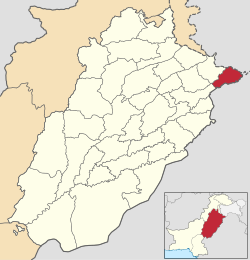
![]() Map of Narowal in Punjab | |
Country | ![]() |
Province | ![]() |
Division | Gujranwala |
Headquarters | Narowal |
Government | |
• Type | District Administration |
• Deputy Commissioner | Muhammad Shahrukh |
• District Police Officer | Muhammad Naveed Malik SP |
• District Health Officer | N/A |
Area | |
2,337 km2 (902 sq mi) | |
• Rank | 113th in Pakistan |
Elevation | 238 m (781 ft) |
Population (2023) [1] | |
1,950,954 | |
• Rank | 42nd in Pakistan |
• Density | 830/km2 (2,200/sq mi) |
• Rank | 29th in Pakistan |
• Urban | 349,095 (17.89%) |
• Rural | 1,601,859 (82.11%) |
Demonym | Narowali |
Literacy | |
• Literacy rate |
|
Time zone | UTC+5 (PST) |
Area code | 0542 |
Number of Tehsils | 3 |
Number of Universities | 4 |
Number of Medical Colleges | 2 (150 + 100 Seats) |
Website | narowal |
Narowal District [a] is a district within the Gujranwala Division of Punjab, Pakistan. The city of Narowal serves as the headquarters of the district. It was formed in 1991 when the two tehsils of Narowal and Shakargarh were split off from Sialkot District. [3]
The district is administratively divided into the following three tehsils (subdivisions), which contain a total of 74 Union Councils: [4]
Tehsil [5] | Area (km²) [6] | Pop. (2023) | Density (ppl/km²) (2023) | Literacy rate (2023) [7] | Union Councils |
---|---|---|---|---|---|
Shakargarh | 835 | 769,339 | 921.36 | 76.28% | 28 |
Narowal | 1,065 | 680,402 | 638.88 | 76.78% | 28 |
Zafarwal | 437 | 501,213 | 1,146.94 | 71.72% | 26 |
The district has six urban areas.
City | Area (km²) | Pop. (2023) | Density (ppl/km²) (2023) | Literacy rate (2023) |
---|---|---|---|---|
Narowal | 200 | 130,692 | ... | ... |
Shakargarh | ... | 126,742 | ... | ... |
Zafarwal | 10 | 52,639 | ... | ... |
Qila Sobha Singh | ... | 19,671 | ... | ... |
Baddomalhi | ... | 19,351 | ... | ... |
Talwandi Bhindran | ... | 13,000 | ... | ... |
The district is bounded by Sialkot District on the northwest , by India on the north, by Kathua district of Jammu and Kashmir, Gurdaspur and Pathankot districts on the southeast, Amritsar district on the south, and Sheikhupura district in Pakistan on the southwest.
Year | Pop. | ±% p.a. |
---|---|---|
1951 | 512,475 | — |
1961 | 550,425 | +0.72% |
1972 | 834,501 | +3.86% |
1981 | 908,977 | +0.95% |
1998 | 1,265,097 | +1.96% |
2017 | 1,707,575 | +1.59% |
2023 | 1,950,954 | +2.25% |
Sources: [8] |
As of the 2023 census, Narowal district had a population of 1,950,954 which is roughly equal to the population of Santa Clara County, California, USA and Huangpu District, Guangzhou, China. There are 281,536 households. The district has a sex ratio of 104.40 males to 100 females and a literacy rate of 75.28%: 79.89% for males and 70.49% for females. [1] [9] 494,799 (25.36% of the surveyed population) are under 10 years of age. [10] 349,095 (17.89%) live in urban areas. [1] According to the 2017 census, total population of District Narowal is 1.709 million. Male population is 0.853 m (49.96%) and female population is 0.855 m (50.04%).[ permanent dead link ] According to the 1998 census of Pakistan, Narowal District's population was 1,256,097, of which only 12.11% were urban. [11]
The total area of the district is approximately 2,337 square kilometres. Prior to the creation of Zafarwal Tehsil in July 2009, [12] Narowal Tehsil occupied 1,065 square kilometres while the remaining area (1,272 square kilometres) fell in Shakargarh Tehsil.
As of 2023, 97.48% of the population adheres to Islam whereas 2.22% adheres to Christianity. There is a small Hindu population in the district. [13]
Religious group | 1941 [14] : 60 | 2017 [15] | 2023 [13] | |||
---|---|---|---|---|---|---|
Pop. | % | Pop. | % | Pop. | % | |
Islam ![]() | 296,582 | 53.05% | 1,663,508 | 97.42% | 1,901,645 | 97.48% |
Hinduism ![]() | 170,883 | 30.56% | 657 | 0.04% | 833 | 0.04% |
Sikhism ![]() | 67,267 | 12.03% | — | — | 125 | 0.01% |
Christianity ![]() | 24,127 | 4.32% | 37,910 | 2.22% | 43,421 | 2.23% |
Ahmadiyya ![]() | — | — | 5,430 | 0.32% | 4,491 | 0.23% |
Others | 244 | 0.04% | 70 | ~0% | 254 | 0.01% |
Total Population | 559,103 | 100% | 1,707,575 | 100% | 1,950,769 | 100% |
Note: 1941 census data is for Narowal tehsil of Sialkot district and Shakargarh tehsil of Gurdaspur district, which roughly corresponds to contemporary Narowal district. District and tehsil borders have changed since 1941. |
At the time of the 2023 census, 94.29% of the population spoke Punjabi, 3.05% Urdu and 2.28% Mewati as their first language. [16]
District Narowal boasts a robust educational infrastructure, featuring a total of 1,609 schools that cater to students at the foundational and secondary levels. Higher education is supported by 35 colleges, which include 8 for boys, 4 for girls, and 3 dedicated commerce colleges, providing a range of academic and professional programs. In addition, the presence of 3 universities further enhances the opportunities for advanced studies and research, contributing significantly to the overall development of education in the area. [17]
Here is the list of universities & medical colleges in Narowal:
University/Campus | Established | Specialization | Type |
---|---|---|---|
University of Narowal | 2018 | General | Public |
University of Engineering and Technology, Lahore, Narowal campus | 2012 | General | Public |
University of Veterinary and Animal Sciences, Narowal campus [18] | 2017 | General | Public |
Narowal Medical College [19] | 2024 | Medical | Public |
Virtual University of Pakistan, Narowal virtual campus | General | Private | |
Sahara Medical College Narowal | 2015 | Medical | Private |
**University of Narowal (UoN) was previously the Narowal campus of University of Gujrat (UoG), but later on UoN became an independent university. Now there is no campus of UoG in Narowal.
The following hospitals operate in Narowal district:
Name | Type | Established | Beds |
---|---|---|---|
DHQ Hospital, Narowal | Public | 1991 | 300 |
Sughra Shafi Medical Hospital Complex | Private | 2003 | 600 |
Provincial Assembly Constituency | National Assembly Constituency |
---|---|
PP-54 Narowal-I | NA-75 Narowal-I |
PP-55 Narowal-II | |
PP-56 Narowal-III | NA-76 Narowal-II |
PP-57 Narowal-IV | |
PP-58 Narowal-V |