Hinduism in Punjab, Pakistan Last updated October 27, 2025 Overview of the role and impact of Hinduism in the Pakistani province of Punjab
Hinduism is a minority religion in Punjab province of Pakistan followed by about 0.19% of its population. Punjab has the second largest number of Hindus in Pakistan after Sindh . [ 3] Hinduism is followed mainly in the districts of Rahim Yar Khan , Bahawalpur , Bahawalnagar and Sialkot . [ 4]
Hinduism has a strong historical presence in Punjab with many mandirs , shrines (samadhis ), alongside various religious traditions and texts that were developed in the region. According to the 1941 census, Punjabi Hindus constituted approximately 13.7 percent of the population in the region that comprises the contemporary state of Punjab, Pakistan . [ a] With violence and religious cleansing accompanying the partition of India in 1947, the vast majority departed the region en masse , primarily migrating eastward to Delhi and the region of Punjab that would fall on the eastern side of the Radcliffe Line , in the contemporary Indian states of Punjab , Haryana , and Himachal Pradesh .
History One of the Amb Temples constructed between the 7th and 9th centuries. Hindu Population HistoryPunjab, Pakistan Year 1881 1,449,913 — 1901 1,944,363 +1.48% 1911 1,645,758 −1.65% 1921 1,797,141 +0.88% 1931 1,957,878 +0.86% 1941 2,373,466 +1.94% 1951 33,052 −34.78% 1998 116,410 +2.72% 2017 211,641 +3.20% 2023 249,716 +2.80% Source: [ b] [ c] [ d] [ e] [ f] [ a] [ 14] [ 15] [ 16] [ 17] [ 1] Census of India , Census of Pakistan
Colonial era By the early 20th century, Western Punjab (present-day Punjab, Pakistan ) had a Punjabi Muslim majority population (primarily supporting the Muslim League and Pakistan Movement ) but also included significant Punjabi Hindu and Punjabi Sikh minority populations.
According to the 1941 census, Punjabi Hindus constituted approximately 13.7 percent of the population in the region that comprises the contemporary state of Punjab, Pakistan , numbering around 2.4 million persons. [ a] Following the partition of Punjab , according to the 1951 census , the Hindu population declined to 33,052 persons or 0.2 percent due to religious cleansing violence alongside large-scale mass migration and population transfer to East Punjab, India and Delhi in the violent events of partition of India . [ 14]
With the formation of independent Pakistan and India during the partition of India in 1947, approximately 3 million Punjabi Hindus migrated to India. [ 29] [ 30] [ 31]
Demographics Hindu Khatri man, Lahore circa 1859-1869 Hindu Arora Storekeeper, Lahore , circa 1862–72 Rattan Chand temple, Lahore , 1880 Hindu Shivite temple, Lahore , 1914 Colonial era Hindus in the administrative divisions that compose the contemporary Punjab, Pakistan region (1881–1941) District or Princely State 1881 [ 5] [ 6] [ 7] [ 32] 1901 [ 8] : 34 [ 33] : 62 1911 [ 9] : 27 [ 10] : 27 1921 [ 11] : 29 1931 [ 12] : 277 1941 [ 13] : 42 Pop. % Pop. % Pop. % Pop. % Pop. % Pop. % Sialkot District 299,311 29.57% 302,012 27.86% 242,325 24.74% 217,912 23.24% 206,421 21.07% 231,319 19.43% Lahore District 193,319 20.92% 276,375 23.78% 217,609 21% 255,690 22.6% 259,725 18.84% 284,689 16.79% Gujranwala District 127,322 20.64% 169,594 22.41% 176,075 19.07% 101,566 16.29% 92,764 12.6% 108,115 11.85% Multan District 112,001 20.29% 133,560 18.79% 126,603 15.54% 134,013 15.05% 182,029 15.49% 249,872 16.83% Shakargarh Tehsil [ g] 109,241 49.77% 111,819 47.69% 93,052 44.22% 90,645 42.59% 101,318 40.96% 116,553 39.98% Bahawalpur State 91,272 15.92% 114,670 15.91% 109,548 14.03% 114,621 14.67% 149,454 15.18% 174,408 13% Rawalpindi District 86,162 10.5% 86,269 9.27% 48,449 8.84% 57,185 10.05% 59,485 9.38% 82,478 10.5% Montgomery District 83,974 19.69% 109,945 23.72% 66,803 12.48% 94,791 13.28% 136,783 13.68% 210,966 15.87% Gujrat District 72,450 10.51% 69,346 9.24% 49,430 6.63% 62,529 7.59% 73,356 7.95% 84,643 7.66% Jhang District 64,892 16.42% 79,650 21.03% 73,426 14.24% 85,339 14.96% 102,990 15.49% 129,889 15.81% Jhelum District 60,949 10.34% 51,801 8.72% 34,261 6.7% 34,837 7.3% 36,068 6.67% 40,888 6.49% Shahpur District 59,026 14% 68,489 13.06% 72,695 10.58% 82,182 11.42% 90,561 11.02% 102,172 10.23% Dera Ghazi Khan District 46,697 12.85% 57,815 12.27% 56,485 11.3% 56,346 12.01% 57,217 11.65% 67,407 11.59% Muzaffargarh District 43,297 12.79% 52,221 12.87% 68,158 11.97% 69,878 12.29% 72,577 12.27% 90,643 12.72% Lyallpur District [ h] — — 210,459 26.58% 154,603 18.03% 181,488 18.53% 173,344 15.06% 204,059 14.61% Mianwali District — — 50,202 11.82% 36,326 10.64% 45,974 12.83% 49,794 12.1% 62,814 12.41% Biloch Trans–Frontier Tract — — 136 0.56% 169 0.59% 180 0.67% 173 0.58% 160 0.4% Attock District [ i] — — — — 19,741 3.8% 26,184 5.11% 31,932 5.47% 43,209 6.39% Sheikhupura District [ j] — — — — — — 85,781 16.4% 81,887 11.75% 89,182 10.46% Total Hindus 1,449,913 18.26% 1,944,363 18.65% 1,645,758 14.82% 1,797,141 15.12% 1,957,878 13.94% 2,373,466 13.68% Total Population 7,942,399 100% 10,427,765 100% 11,104,585 100% 11,888,985 100% 14,040,798 100% 17,350,103 100%
Modern era According to the 2023 Cenus , Hinduism is followed by 0.2 percent of the population, [ 34] which is roughly the same proportion as reported in the 2017 Census. [ 3] There are 249,716 Hindus in Punjab. [ 34] However according to the Pakistan Hindu Council , there are 349,230 Hindus in Punjab. [ 35]
According to estimates in religious minorities in Pakistan's elections, there are above 50,000 or more in 11 districts in Pakistan. All of these are in Sindh except the Rahim Yar Khan District in Punjab and is the only district in Punjab with more than 2% of its population as Hindu . [ 36]
About 90% of the Hindus in Punjab province live in Rahim Yar Khan and Bahawalpur . [ 37]
Hindus in the administrative divisions in Punjab, Pakistan (1951–2023) District 1951 [ 14] 2017 [ 16] [ 17] 2023 [ 1] Pop. % Pop. % Pop. % Sialkot District 14,397 0.98% 2,870 0.07% 3,195 0.07% Rahim Yar Khan District 10,755 1.26% 150,093 3.12% 176,416 3.17% Lahore District 2,433 0.13% 2,670 0.02% 2,811 0.02% Bahawalpur District 1,916 0.2% 41,051 1.12% 48,684 1.14% Gujranwala District 1,211 0.12% 287 0.01% 1,033 0.02% Faisalabad District 888 0.04% 598 0.01% 2,150 0.02% Sheikhupura District 461 0.05% 323 0.01% 820 0.02% Attock District 308 0.04% 575 0.03% 501 0.02% Multan District 151 0.01% 2,366 0.05% 1,709 0.03% Rawalpindi District 114 0.01% 1,244 0.02% 1,013 0.02% Gujrat District 99 0.01% 120 0% 217 0.01% Sahiwal District 90 0% 297 0.01% 217 0.01% Jhelum District 72 0.01% 356 0.03% 343 0.03% Jhang District 69 0.01% 195 0.01% 73 0% Sargodha District 58 0% 141 0% 456 0.01% Muzaffargarh District 24 0% 733 0.02% 716 0.01% Dera Ghazi Khan District 6 0% 248 0.01% 166 0% Mianwali District 0 0% 21 0% 63 0% Bahawalnagar District — — 2,631 0.09% 3,106 0.09% Rajanpur District — — 1,442 0.07% 1,030 0.04% Narowal District — — 657 0.04% 833 0.04% Layyah District — — 553 0.03% 252 0.01% Mandi Bahauddin District — — 357 0.02% 326 0.02% Khanewal District — — 297 0.01% 304 0.01% Nankana Sahib District — — 245 0.02% 1,196 0.07% Kasur District — — 243 0.01% 475 0.01% Okara District — — 214 0.01% 214 0.01% Chakwal District — — 187 0.01% 142 0.01% Vehari District — — 179 0.01% 226 0.01% Toba Tek Singh District — — 123 0.01% 279 0.01% Pakpattan District — — 97 0.01% 61 0% Lodhran District — — 93 0.01% 97 0.01% Chiniot District — — 62 0% 132 0.01% Hafizabad District — — 48 0% 380 0.03% Bhakkar District — — 13 0% 25 0% Khushab District — — 12 0% 55 0% Total Hindus 33,052 0.16% 211,641 0.19% 249,716 0.2% Total responses 20,636,702 100% 109,989,655 100% 127,333,305 99.72% Total population 20,636,702 100% 109,989,655 100% 127,688,922 100%
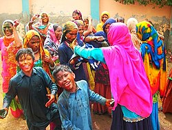
Hindus in Punjab is mainly concentrated in the Bahawalpur Division . According to a study, the majority (86.5%) of the scheduled caste Hindus in Bahawalpur Division have experienced discrimination. The study found that majority (i.e 91.5%) of the respondents in Rahimyar Khan districts believed that political parties are not giving importance to them. [ 38] In Central Punjab, the population of Hindus are very low, so many of the Hindus have married Sikhs and vice versa. Intermarriages between the Hindus and Sikh community are very common there. [ 39] The Forced conversion of Hindu girls are a problem faced by the Hindu community. According to a report by Minority Rights Commission, the number of forced conversions and forced marriages increasing in Bahawalpur Division , particularly the Rahim Yar Khan District and adjacent areas. [ 40]
Hindu marriages in Punjab are registered under the Hindu marriage act of 2017 . [ 41] [ 42]
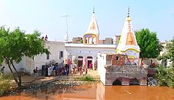
Temples There are many temples in the Punjab and mainly of them served as a worship place for multi-religious community. The notable of them includes:
Notes 1 2 3 1941 figure taken from census data by combining the total population of all districts (Lahore , Sialkot , Gujranwala , Sheikhupura , Gujrat , Shahpur , Jhelum , Rawalpindi , Attock , Mianwali , Montgomery , Lyallpur , Jhang , Multan , Muzaffargargh , Dera Ghazi Khan ), one tehsil (Shakargarh – then part of Gurdaspur District ), one princely state (Bahawalpur ), and one tract (Biloch Trans–Frontier) in Punjab Province, British India that ultimately fell on the western side of the Radcliffe Line . See 1941 census data here: [ 13] : 42 partition of India in 1947 , these districts and tract would ultimately make up the subdivision of West Punjab, which also later included Bahawalpur . The state that makes up this region in the contemporary era is Punjab, Pakistan . ↑ 1881 figure taken from census data by combining the total population of all districts (Lahore , Sialkot , Gujranwala , Gujrat , Shahpur , Jhelum , Rawalpindi , Montgomery , Jhang , Multan , Muzaffargargh , Dera Ghazi Khan ), one tehsil (Shakargarh – then part of Gurdaspur District ), and one princely state (Bahawalpur ) in Punjab province, British India that ultimately fell on the western side of the Radcliffe Line . See 1881 census data here: [ 5] [ 6] [ 7] Bahawalpur . The state that makes up this region in the contemporary era is Punjab, Pakistan . ↑ 1901 figure taken from census data by combining the total population of all districts (Lahore , Sialkot , Gujranwala , Gujrat , Shahpur , Jhelum , Rawalpindi , Mianwali , Montgomery , Lyallpur (inscribed as the Chenab Colony on the 1901 census), Jhang , Multan , Muzaffargargh , Dera Ghazi Khan ), one tehsil (Shakargarh – then part of Gurdaspur District ), one princely state (Bahawalpur ), and one tract (Biloch Trans–Frontier) in Punjab Province, British India that ultimately fell on the western side of the Radcliffe Line . See 1901 census data here: [ 8] : 34 Bahawalpur . The state that makes up this region in the contemporary era is Punjab, Pakistan . ↑ 1911 figure taken from census data by combining the total population of all districts (Lahore , Sialkot , Gujranwala , Gujrat , Shahpur , Jhelum , Rawalpindi , Attock , Mianwali , Montgomery , Lyallpur , Jhang , Multan , Muzaffargargh , Dera Ghazi Khan ), one tehsil (Shakargarh – then part of Gurdaspur District ), one princely state (Bahawalpur ), and one tract (Biloch Trans–Frontier) in Punjab Province, British India that ultimately fell on the western side of the Radcliffe Line . See 1911 census data here: [ 9] : 27 [ 10] : 27 partition of India in 1947 , these districts and tract would ultimately make up the subdivision of West Punjab, which also later included Bahawalpur . The state that makes up this region in the contemporary era is Punjab, Pakistan . ↑ 1921 figure taken from census data by combining the total population of all districts (Lahore , Sialkot , Gujranwala , Sheikhupura , Gujrat , Shahpur , Jhelum , Rawalpindi , Attock , Mianwali , Montgomery , Lyallpur , Jhang , Multan , Muzaffargargh , Dera Ghazi Khan ), one tehsil (Shakargarh – then part of Gurdaspur District ), one princely state (Bahawalpur ), and one tract (Biloch Trans–Frontier) in Punjab Province, British India that ultimately fell on the western side of the Radcliffe Line . See 1921 census data here: [ 11] : 29 partition of India in 1947 , these districts and tract would ultimately make up the subdivision of West Punjab, which also later included Bahawalpur . The state that makes up this region in the contemporary era is Punjab, Pakistan . ↑ 1931 figure taken from census data by combining the total population of all districts (Lahore , Sialkot , Gujranwala , Sheikhupura , Gujrat , Shahpur , Jhelum , Rawalpindi , Attock , Mianwali , Montgomery , Lyallpur , Jhang , Multan , Muzaffargargh , Dera Ghazi Khan ), one tehsil (Shakargarh – then part of Gurdaspur District ), one princely state (Bahawalpur ), and one tract (Biloch Trans–Frontier) in Punjab Province, British India that ultimately fell on the western side of the Radcliffe Line . See 1931 census data here: [ 12] : 277 partition of India in 1947 , these districts and tract would ultimately make up the subdivision of West Punjab, which also later included Bahawalpur . The state that makes up this region in the contemporary era is Punjab, Pakistan . ↑ Part of Gurdaspur District which was awarded to Pakistan as part of the Radcliffe Line . ↑ District formerly inscribed as the Chenab Colony on the 1901 census, later renamed to Lyallpur District , created between Jhang District , Gujranwala District , Lahore District , Montgomery District , and Multan District to account for the large population increase in the region, primarily due to the Chenab Canal Colony . ↑ District created in 1904 by taking Talagang Tehsil from Jhelum District and Pindi Gheb , Fateh Jang and Attock Tehsils from Rawalpindi District . ↑ District created between Gujranwala District , Sialkot District , Amritsar District , Lahore District , Montgomery District , and Lyallpur District in 1920 to account for the large population increase in the region, primarily due to the Chenab Canal Colony . References 1 2 3 "7th Population and Housing Census - Detailed Results Table-9 Population by sex, religion and rural/urban" . Pakistan Bureau of Statistics . Retrieved 20 October 2024 . ↑ Aiza Hussain. "An evening with the Hindu Marwari of Cholistan" . Dawn . Retrieved 22 May 2021 . 1 2 "SALIENT FEATURES OF FINAL RESULTS CENSUS-2017" (PDF) . Retrieved 21 May 2021 . ↑ "Population Distribution by Religion, 1998 Census" (PDF) . Pakistan Bureau of Statistics . Retrieved 21 May 2021 . 1 2 "Census of India, 1881 Report on the Census of the Panjáb Taken on the 17th of February 1881, vol. I." 1881. JSTOR saoa.crl.25057656 . Retrieved 7 April 2024 . 1 2 "Census of India, 1881 Report on the Census of the Panjáb Taken on the 17th of February 1881, vol. II" . 1881. p. 14. JSTOR saoa.crl.25057657 . Retrieved 7 April 2024 . 1 2 "Census of India, 1881 Report on the Census of the Panjáb Taken on the 17th of February 1881, vol. III" . 1881. p. 14. JSTOR saoa.crl.25057658 . Retrieved 7 April 2024 . 1 2 "Census of India 1901. [ Vol. 17A] . Imperial tables, I-VIII, X-XV, XVII and XVIII for the Punjab, with the native states under the political control of the Punjab Government, and for the North-west Frontier Province" . 1901. JSTOR saoa.crl.25363739 . Retrieved 10 March 2024 . 1 2 "Census of India 1911. Vol. 14, Punjab. Pt. 2, Tables" . 1911. JSTOR saoa.crl.25393788 . Retrieved 3 March 2024 . 1 2 Kaul, Harikishan (1911). "Census Of India 1911 Punjab Vol XIV Part II" . Retrieved 3 March 2024 . 1 2 "Census of India 1921. Vol. 15, Punjab and Delhi. Pt. 2, Tables" . 1921. JSTOR saoa.crl.25430165 . Retrieved 17 February 2024 . 1 2 "Census of India 1931. Vol. 17, Punjab. Pt. 2, Tables" . 1931. JSTOR saoa.crl.25793242 . Retrieved 4 February 2024 . 1 2 India Census Commissioner (1941). "Census of India, 1941. Vol. 6, Punjab" . JSTOR saoa.crl.28215541 . Retrieved 19 January 2023 . 1 2 3 "Census of Pakistan, 1951 Population According to Religion Table 6" . pp. 12– 21. Retrieved 11 February 2024 . ↑ "Population Distribution by Religion, 1998 Census" (PDF) . Retrieved 26 January 2023 . 1 2 "Final Results (Census-2017)" . Pakistan Bureau of Statistics . Retrieved 20 October 2024 . 1 2 "TABLE 9 - POPULATION BY SEX, RELIGION AND RURAL/URBAN" (PDF) . Retrieved 26 January 2023 . ↑ Nayar, Kamala Elizabeth (2012). The Punjabis in British Columbia: Location, Labour, First Nations, and Multiculturalism McGill–Queen's University Press . p. 7. ISBN 978-0-7735-4070-5 . Retrieved October 2, 2023 . Hinduism is the oldest of the religions practiced by the Punjabis ↑ "Rigveda | Hindu literature" . Encyclopædia Britannica . Retrieved 21 May 2021 . ↑ Needham, Joseph (2004). Within the Four Seas: The Dialogue of East and West . Routledge. ISBN 0-415-36166-4 ↑ Kulke, Hermann ; Rothermund, Dietmar (2004). A History of India (4th ed.). Routledge. ISBN 0-415-32919-1 ↑ Ghose, Sanujit (2004). Legend of Ram: Antiquity to Janmabhumi Debate ISBN 9788185002330 ↑ Sinha, Amita; Silva, Kapila D. (2016). Cultural Landscapes of South Asia: Studies in Heritage Conservation and Management ISBN 9781317365938 . Retrieved 14 September 2017 . ↑ Charak, Sukh Dev Singh (1978). Himachal Pradesh, Volume 1 . Light & Life Publishers. ↑ Hutchison, John (1933). History of the Panjab Hill States, Volume 1 . Asian Educational Services. ISBN 9788120609426 ↑ Eaton, Richard Maxwell, 1940- ... (2006). Essays on Islam and Indian history . Oxford University Press. ISBN 0-19-566265-2 OCLC 469584446 . {{cite book }}: CS1 maint: multiple names: authors list (link ) CS1 maint: numeric names: authors list (link ) ↑ MacLagan, Sir Edward (1926). Gazetteer of the Multan District, 1923–24 Sir Edward Maclagan, Punjab (Pakistan) 276– 77. ↑ "Navjot Singh Sidhu thinks there are 14 crore Sikhs in India instead of 2.4 crore" . Free Press Journal . Retrieved 2021-05-21 . ↑ Salamat, Zarina (1997). The Punjab in 1920's: a case study of Muslims . Karachi: Royal Book Company. p. 145. ISBN 978-969-407-230-2 OCLC 40480171 . ↑ Banerjee-Dube, Ishita; Dube, Saurabh (2009). Ancient to modern: religion, power, and community in India . New Delhi; Oxford: Oxford University Press. ISBN 978-0-19-569662-2 OCLC 302183130 . ↑ "The partition of India and retributive genocide in the Punjab, 1946–47: means, methods, and purposes" (PDF) . Archived from the original (PDF) on 14 April 2021. Retrieved 19 December 2006 . ↑ "Gazetteers Of Gurdaspur District, 1883-84" . 1884. Retrieved 7 April 2024 . ↑ "Punjab District Gazetteers Gurdaspur District Vol.21 Statistical Tables" . 1913. Retrieved 10 March 2024 . 1 2 "7th Population and Housing Census" . www.pbs.gov.pk . Retrieved 2024-07-21 . ↑ "Hindu Population (PK) – Pakistan Hindu Council" . Archived from the original on 15 March 2018. Retrieved 2019-03-18 . 1 2 3 Aqeel, Asif (1 July 2018), "Problems with the electoral representation of non-Muslims" , Herald (Pakistan) , retrieved 21 May 2021 ↑ "District wise census" . Retrieved 4 August 2021 . ↑ Shah, Zulfiqar (December 2007), Information on Caste Based Discrimination in South Asia, Long Behind Schedule, a Study on the Plight of Scheduled Caste Hindus in Pakistan (PDF) , Indian Institute of Dalit Studies (IIDS) and International Dalit Solidarity Network (IDSN), retrieved 21 May 2021 ↑ Javaid, Maham (18 August 2016), "State of fear" , Herald (Pakistan) , retrieved 21 May 2021 ↑ Zahid Gishkori (3 September 2012). "Intolerance growing in South Punjab: Report" . Retrieved 25 May 2021 . ↑ "Pakistan Senate passes landmark Hindu marriage bill" . The Hindu . 18 February 2017. Retrieved 21 May 2021 . ↑ Kalbe Ali (27 September 2016). "NA finally passes Hindu marriage bill" . Dawn . Retrieved 21 May 2021 . ↑ "ECP announces by-polls on vacant seats" . www.pakistantoday.com.pk . Archived from the original on 27 January 2018. Retrieved 27 January 2018 . ↑ "Hindus get representation in Punjab Assembly of Pakistan after 16 years" . India Today . 13 June 2013. Archived from the original on 27 January 2018. Retrieved 27 January 2018 . This page is based on this
Wikipedia article Text is available under the
CC BY-SA 4.0 license; additional terms may apply.
Images, videos and audio are available under their respective licenses.