
Punjab is a province of Pakistan. Located in central-eastern region of the country, Punjab is the second-largest province of Pakistan by land area and the largest by population. Lahore is the capital and the largest city of the province. Other major cities include Faisalabad, Rawalpindi, Gujranwala and Multan.

Faridkot is a city in the South-western part of state of Punjab, India. It serves as the headquarters for both, the Faridkot district. as well as the Faridkot Division. The division was established in 1995 at Faridkot which includes Faridkot, Bathinda, and Mansa districts.

Rupnagar is a city and a municipal council in Rupnagar district in the Indian state of Punjab. Rupnagar is a newly created fifth Divisional Headquarters of Punjab comprising Rupnagar, Mohali, and its adjoining districts. It is also one of the bigger sites belonging to the Indus Valley civilization. Rupnagar is nearly 43 km (27 mi) to the northwest of Chandigarh. It is bordered by Himachal Pradesh to the north and Shahid Bhagat Singh Nagar district to its west.

Ludhiana district is one of the 23 districts in the Indian state of Punjab. It is Punjab's largest district by both area and population. Ludhiana, the largest city in Punjab, is the district headquarters.

Moga district is one of the twenty-two districts in the state of Punjab, India. It became the 17th district of Punjab State on 24 November 1995 cut from Faridkot district. Moga District is among the largest producers of wheat and rice in Punjab, India. People from Moga City and Moga District belong to the Malwa culture. The district is noted for being the homeland for a high proportion of Indian Punjabi expatriates who emigrated abroad and their descendents, which has given it the nickname of "NRI district".
Moga is a city in the Indian state of Punjab. It was made a part and headquarters of the Moga district on 24 November 1995, by the then Chief Minister Harcharan Singh Brar. Before becoming a district, Moga was a part of Faridkot District as a tehsil. Moga is situated on the National Highway 95. The area of Dharamkot block with 150 villages has been merged into Moga district, which falls under the jurisdiction of Ferozpur division.
Kotkapura is a historic city in Faridkot district, Punjab, India. some 15 km from Faridkot City, 50 km from Bathinda, 40 km from Moga and 30 km from Muktsar in the state of Punjab, India. It is the largest city in the Faridkot District and has a large cotton market. It takes around 15 minutes by bus from Faridkot, 4 hours by road from Chandigarh and 2 hours from Ludhiana, and 8 hours from New Delhi by train to reach the city. It is a central city on route to Ganganagar, Ludhiana, Bathinda, Firozpur, etc. KotkKapura takes its name from its founder, Nawab Kapur Singh, and the word 'Kot', meaning a small fort – literally the 'Fort of Kapura'. The city is known for its "Dhodha Sweet" and "Atta Chicken" both of which are exported outside India.
Jaitu is a historical city. Jaitu is a municipal council in Faridkot district in the Indian state of Punjab. It is subdivision in Ferozepur Division. It is 30 km (19 mi) from Bathinda, 130 km (81 mi) from Ludhiana, 150 km (93 mi)from Amritsar, 180 km (110 mi) from Patiala and 234 km (145 mi) from Chandigarh.
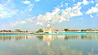
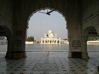
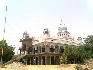
Sri Muktsar Sahib is a historical city and district headquarters in Punjab, India. The 2011 Census of India put the total population of Sri Muktsar Sahib municipality at 117,085, making it the 14th largest city of Punjab, in terms of population. The second Guru of the Sikhs, Guru Angad was born in the village Matte-di-Sarai (Sarainaga) in the same district. Earlier the city was called Khidrana/Khidrane di dhab, the city was named Muktsar after the Battle of Muktsar in 1705 and the district headquarters in 1995. The government officially changed the name of the city to Sri Muktsar Sahib in 2012, though the city is still primarily referred to by its unofficial name – Muktsar.

Nohar is a city and a municipality in Hanumangarh district in the Indian state of Rajasthan India

Tara Garh, is a village in the Pattoki tehsil of Kasur District in the Punjab (Pakistan). the village is based on a single nation known as klair bradri.
Mehatpur is a village in Jalandhar district in the Indian state of Punjab.As of the 2011 Census of India, the population was 5,804 people across 1186 households. It is 8 km away from Nakodar on National Highway 71 (NH-71).
Dhudike is a village in Moga Tehsil in Moga district of Punjab state, India. It is located 17 km east from city of Moga, the district headquarter. Freedom fighters like Baba Ishar Singh, Baba Pala Singh Jathedar, Baba Pakhar Singh are a few of the Gadaree from Dhudike who participated in the Gadar Movement during the struggle for independence. Dhudike is the birthplace of the famous revolutionary Lala Lajpat Rai.

Punjab is a state in northwestern India. Forming part of the larger Punjab region of the Indian subcontinent, the state is bordered by the Indian states of Himachal Pradesh to the north and northeast, Haryana to the south and southeast, and Rajasthan to the southwest; by the Indian union territories of Chandigarh to the east and Jammu and Kashmir to the north. It shares an international border with Punjab, a province of Pakistan to the west. The state covers an area of 50,362 square kilometres, which is 1.53% of India's total geographical area, making it the 19th-largest Indian state by area out of 28 Indian states. With over 27 million inhabitants, Punjab is the 16th-largest Indian state by population, comprising 23 districts. Punjabi, written in the Gurmukhi script, is the most widely spoken and the official language of the state. The main ethnic group are the Punjabis, with Sikhs (57.7%) and Hindus (38.5%) forming the dominant religious groups. The state capital, Chandigarh, is a union territory and also the capital of the neighbouring state of Haryana. Three tributaries of the Indus River — the Sutlej, Beas, and Ravi — flow through Punjab.
Buttar Sarinh, incorrect spellings include Buttar Shrin and Buttar Shri, is a small village in the Giddarbaha tehsil of Sri Muktsar Sahib district in Punjab, India. It's located on the Sri Muktsar Sahib-Bathinda main road.
Raipur, located in the Sardulgarh tehsil of Mansa district in Punjab, India, is an old and noted village of the area. The famous Babbar martyr Bhai Gurmel Singh from the village was martyred during an operation in Maujia on 8 September 1991.
Palam is a major residential colony located in South West Delhi. It is one of 70 Vidhan Sabha constituencies of the Delhi National Capital Territory in northern India.
Ramgarh Sardaran is a village in Punjab state of India. It is situated 18 km from its tehsil Payal and approx. 40 km from its district ludhiana. As per 2014 stats, Ramgarh Sardaran village is also a gram panchayat.
Apra also known as The Golden City Apra is a census town in Phillaur Tehsil in Jalandhar district of Punjab State, India. The town is known for gold jewelry and paddy crops which are produced in large amounts. It is located 46 kilometres (29 mi) towards East from Jalandhar, 12 kilometres (7.5 mi) from Phillaur and 110 kilometres (68 mi) from Chandigarh. Apra is the largest town as compared to other surrounding villages and has the main marketplace. The town is administrated by Sarpanch an elected representative of the village.
Vakilan Wala is the northernmost village of the Indian state of Punjab situated near Zira City, Punjab, and the international border of India and Pakistan. It is the administrative headquarters of Ferozepur District.

