
The Geography of Pakistan encompasses a wide variety of landscapes varying from plains to deserts, forests, and plateaus ranging from the coastal areas of the Indian Ocean in the south to the mountains of the Karakoram, Hindukush, Himalayas ranges in the north. Pakistan geologically overlaps both with the Indian and the Eurasian tectonic plates where its Sindh and Punjab provinces lie on the north-western corner of the Indian plate while Balochistan and most of Khyber Pakhtunkhwa lie within the Eurasian plate which mainly comprises the Iranian Plateau.
Jhelum District is a district, located partially on the Pothohar Plateau and in Indus Plain, in Punjab, Pakistan. Jhelum is one of the oldest districts of Punjab. It was established on 23 March 1849. Jhelum is known for providing many soldiers to the British and later to the Pakistan armed forces due to which it is also known as 'city of soldiers' or 'land of martyrs and warriors'. The district of Jhelum stretches from the river Jhelum almost to the Indus. Salt is quarried at the Mayo mine in the Salt Range. There are two coal mines in the district from which the North-Western railway obtains parts of its supply. These are the only coal mines in Punjab province which are in working condition. The chief center of the salt trade is Pind Dadan Khan. The district is crossed by the main line of the North-Western railway and also traversed along the south by a branch line. It is located in the north of the Punjab province, Jhelum district is bordered by Sargodha and Mandi Bahauddin to its south, Khushab to its southwest, Jhelum River to its south and east, Gujrat to its east, Chakwal to its west, Mirpur to its northeast, and Rawalpindi to its north.

Bilaspur is a district of Himachal Pradesh, India. Its capital is in the town of Bilaspur. The district has an area of 1,167 km2, and a population of 381,956. As of 2011 it is the third least populous district of Himachal Pradesh, after Lahul and Spiti and Kinnaur.

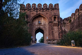
The Salt Range is a mountain range in the north of Punjab province of Pakistan, deriving its name from its extensive deposits of rock salt. The range extends along the south of the Potohar Plateau and the north of the Jhelum River. The Salt Range contains the great mines of Khewra, Kalabagh and Warcha which yield vast supplies of salt. Coal of a medium quality is also found here. The Salt Range starts from the Bakralla and Tilla Jogian ridges in the east and extends to the west of River Jhelum.
Khushab District, is a district in the province of Punjab, Pakistan, with its administrative capital in Jauharabad. The district is named after the historical city of Khushab.

Pathankot is a city and the district headquarters of the Pathankot district in Punjab, India. Pathankot is the 6th most populous city of Punjab, after Ludhiana, Amritsar, Jalandhar, Patiala and Bathinda. Its local government is a municipal corporation.

Udhampur is an administrative district in the Jammu division of Indian-administered Jammu and Kashmir in the disputed Kashmir region. Covering an area of 4,550 square kilometres (1,760 sq mi) in the Himalayan mountains, the district has its headquarters in the town of Udhampur. The Northern Command headquarters of the Indian Army is located in the district.

Soon Valley also spelt as Soan Valley is in the north west of Khushab District, Punjab, Pakistan. Its largest settlement is the town of Naushera. The valley Have Multiple famous personalities like Ahmed Nadeem Qasmi from uchali and Malik Shakir Bashir awan from Padrar and Major Azhar Malik From Khura Soon Valley Known for his political activities. The Valley extends from the village of Padhrar to Sakesar, the highest peak in the Salt Range. The valley is 35 miles (56 km) long and has an average width of 9 miles (14 km). It covers a 310-square-mile (800 km2) area. Soon Valley has a number of lakes, waterfalls, jungle, natural pools and ponds. The valley has been settled since ancient times, most recently by the Awan tribe, which still resides in the valley.

Uchhali Complex is located in Khushab District, Punjab, Pakistan. Uchhali Complex includes three brackish to saline lakes: Khabikki Lake, Uchhali Lake and Jahlar Lakes. It was designated a Ramsar site on March 22, 1996.
Uchhali is a saltwater lake in Soan Sakaser Valley in the southern Salt Range area in the province of Punjab, Pakistan. This lake is formed due to the absence of drainage in the range.

Khabikki Lake is a salt water lake, in the Soan Sakaser Valley in the southern Salt Range in Khushab District, Punjab, Pakistan. This lake is formed due to the absence of drainage in the range. It is part of Uchhali Wetlands Complex and has been designated a Ramsar site.
Golay Wali is a village that is one of the Union Councils of Khushab District in the Punjab Province of Pakistan. It is located at 32°29'21″N 71°50'46″E.

Buchal Kalan, is a village, union council and administrative sub-division of Chakwal District in the Punjab Province of Pakistan. It is part of the Kallar Kahar Tehsil. As of the most recently available data, the population of Buchal Kalan is 45,000 people and there are 2916 households in the village. Buchal Kalan is located 35 km southwest of Chakwal and 12 km southwest of Kallar Kahar. The elevation of Buchal Kalan is 841 meters and it is situated close to the villages Dharokna and Jhamrah.

Thill, also known as Thill Sharif or Thil, is a village in Jhelum District, Punjab, Pakistan. It is located at 32°42'0N' 73°20'0E with an altitude of 279 metres (918 feet). It is situated between the Jhelum River and Pind Dadan Khan Tehsil. Thill is located near the mountain range where the Khewra Salt Mines are located.

The Ganderbal district, is an Indian-administered district in Jammu and Kashmir in the disputed Kashmir region. It was formed in 2007 and has 6 subdistricts (tehsils): Kangan, Ganderbal, Tullamulla, Wakura, Lar, and Gund.
Kharian Cantonment, (Punjabi: کھاریاں ﮐﻴﻨٹ) or Kharian Cantt is one of the largest cantonments in Pakistan. It is located near Kharian city, in the Gujrat district of Punjab province.

Chitta is one of the 32 villages located in the Soon Sakesar Valley in Khushab District of Pakistan. The population is around 4000. It is located 220 km south-west of Islamabad. The village sits on footsteps of the highest peak of Soon valley; Sakesar and on the edge of the beautiful Uchali lake. The main towns near Chitta are Naushera, Talagang, Khushab and Sargodha.

The Pothohar Plateau, also known as Pothwar, is a plateau in the northern region of Punjab, Pakistan, located between the Indus and Jhelum rivers.

Kotla is the name of a valley in Northern Bagh. The name of the main village of this valley is Kotla, on the basis of which the entire valley was named Kotla Valley. Kotla is a village and tourist resort in Bagh District, Azad Kashmir, Pakistan. Kotla is 6,560 feet (2,000 m) above sea level. Kotla contains pine trees that are hundreds of years old. It takes approximately 1 hour to drive from Bagh to Kotla.

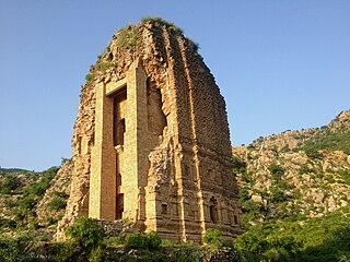
The Amb Temples, locally known as Amb Sharif, are part of an abandoned Hindu temple complex on the Sakesar mountain, located at the western edge of the Salt Range in Pakistan's Punjab province. Although foundations go back to the period of Kushan Empire, the temple complex was built in the 9th to 10th centuries CE during the reign of the Hindu Shahi empire.


