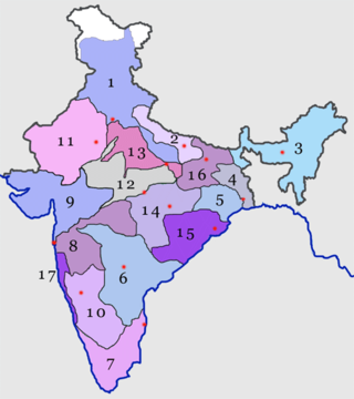
Madhya Pradesh is a state in central India. Its capital is Bhopal, and its largest city is Indore, with Jabalpur, Gwalior, Ujjain, Dewas, Sagar, Chhindwara, and Rewa being the other major cities. Madhya Pradesh is the second largest Indian state by area and the fifth largest state by population with over 72 million residents. It borders the states of Uttar Pradesh to the northeast, Chhattisgarh to the east, Maharashtra to the south, Gujarat to the west, and Rajasthan to the northwest.

Gwalior is a major city in the central Indian state of Madhya Pradesh; it lies in northern part of Madhya Pradesh and is one of the Counter-magnet cities. Located 313 kilometres (194 mi) south of Delhi, the capital city of India and 446 kilometres (277 mi) from Bhopal, the state capital, Gwalior occupies a strategic location in the Gird region of India. The historic city and its fortress have been ruled by several historic Indian kingdoms. From the Alchon Huns in the 5th century AD to Gurjara Pratihara dynasty in the 8th century AD. It was passed on to Kachchhapaghatas in the 10th century AD. It fell into the hands of the Delhi Sultanate in 12th century AD, it was then passed on to the Tomars in the 13th century AD who were the vassal rulers of the Delhi Sultanate. The Mughal Empire conquered the city and its fortress in the 16th century AD. When the Mughal Empire was declining, it fell into the hands of Jat rulers, then to the Maratha in 1754, and lastly it was passed on to the Scindia Dynasty of Maratha Empire in early 18th century. In April 2021, It was found that Gwalior had the best air quality index amongst the 4 major cities in Madhya Pradesh.

Indore is the largest and most populous city in the Indian state of Madhya Pradesh. It is the commercial hub of Madhya Pradesh. It is consistently ranked as the cleanest city in India. It serves as the headquarters of both the Indore District and the Indore Division. It is also considered the state education hub and houses campuses of both the Indian Institute of Technology and the Indian Institute of Management. Located on the southern edge of Malwa Plateau, at an average altitude of 553 meters (1,814 ft) above sea level, it has the highest elevation among major cities of Central India. The city is 190 km (120 mi) west of the state capital of Bhopal. It is 57 km (35 mi) from Ujjain and 35 km (20 mi) from Dewas. Indore had a census-estimated 2011 population of 1,994,397 and 3,570,295. The city is distributed over a land area of just 530 square kilometres (200 sq mi), making Indore the most densely populated major city in the central province.

Meerut is a city in the western region of the Indian state of Uttar Pradesh. Located in the Meerut district, the city is 80 km (80,000 m) northeast of the national capital New Delhi, and is 480 km (300 mi) west of the state capital, Lucknow. Meerut is the second-most populous city in the National Capital Region (NCR), a region centered on Delhi. As of 2011, Meerut is the 33rd most populous urban agglomeration and the 26th most populous city in India.

Ujjain or Ujjayinī is a city in Ujjain district of the Indian state of Madhya Pradesh. It is the fifth-largest city in Madhya Pradesh by population and is the administrative centre of Ujjain district and Ujjain division. It is one of the Hindu pilgrimage centres of Sapta Puri famous for the Kumbh Mela (Simhastha) held there every 12 years. The famous temple of Mahakaleshwar Jyotirlinga is located in the center of the city. The city has been one of the most prominent trade and political centres of the Indian Subcontinent from the time of the ancient Mahājanapadas until the British colonisation of India.
Shivpuri is a city and a municipality in Shivpuri district, located in the central Indian state of Madhya Pradesh. It is in the Gwalior Division of northwest Madhya Pradesh and is the administrative headquarters of Shivpuri District. It is situated at an altitude of 1,515 feet (462 m) above sea level.

Ghaziabad is a city in the Indian state of Uttar Pradesh and a part of Delhi NCR. It is the administrative headquarters of Ghaziabad district and is the largest city in Western Uttar Pradesh, with a population of 1,729,000. Ghaziabad Municipal Corporation is divided into 5 zones - City Zone, Kavi Nagar Zone, Vijay Nagar Zone, Mohan Nagar Zone and Vasundhara Zone. The Municipal Corporation comprises 100 wards. Well connected by roads and railways, it is a major rail junction for North India. It is part of the Meerut Division of Uttar Pradesh.

The North Central Railway is one of the 19 railway zones in India. The largest railway station in NCR is Kanpur Central. It is headquartered at Prayagraj and comprises three divisions: Prayagraj, Jhansi, and Agra of the erstwhile Northern Railway, Jhansi division of the erstwhile Central Railway, and new Agra division.

The National Capital Region is a planning region centred upon the National Capital Territory (NCT) of Delhi in India. It encompasses Delhi and several districts surrounding it from the states of Haryana, Uttar Pradesh, and Rajasthan. The NCR and the associated National Capital Region Planning Board (NCRPB) were created in 1985 to plan the development of the region and to evolve harmonized policies for the control of land-uses and development of infrastructure in the region. Prominent cities of NCR include Delhi, Faridabad, Ghaziabad, Gurgaon and Noida.

Sabalgarh is a municipality in Morena district in the Indian state of Madhya Pradesh.
Dwarka is a neighbourhood located in Southwestern edge of Indian Capital New Delhi in South West Delhi district of the NCT of Delhi. The district court that functions under the Delhi High Court for South West Delhi is located in Dwarka.

Telephone numbers in India are administered under the National Numbering Plan of 2003 by the Department of Telecommunications of the Government of India. The numbering plan was last updated in 2015. The country code "91" was assigned to India by the International Telecommunication Union in the 1960s.

Rajagopal P. V. is an Indian Gandhian activist, a former Vice Chairman of the New Delhi Gandhi Peace Foundation, aswell as the president and founding member of Ekta Parishad. In 1972, Rajagopal started working alongside Gandhian activists J.P. Narayan and Subba Rao to disarm 578 bandits in the Chambal region of India. Thereafter, he stayed away from dealing with direct violence and focused on the people of Adivasis, bonded labourers, and other landless communities affected by poverty and exploitation.
The Western Peripheral Expressway (WPE) or Kundli–Manesar–Palwal Expressway, is an operational 6-lane, 135.6 km (84.3 mi)-long Expressway in the Haryana state of India. Along with the Eastern Peripheral Expressway, the Western Peripheral Expressway is expected to divert more than 50,000 heavy vehicles away from Delhi, which will help to maintain good air quality in Delhi. Western Peripheral Expressway along with Eastern Peripheral Expressway completes the largest Ring Road around Delhi. There are 10 tolled entries and exits, from north to south - Kundli, Kharkhoda, Bahadurgarh, Badli, Fartukhnagar, Panchgaon, Manesar, Taoru, Sohna & Palwal. Toll rate notified in December 2018 is INR1.35 per km for cars, INR2.18 per km for light motor vehicles, INR4.98 per km for trucks and buses, and two wheelers are not permitted on the expressway.

National Highway 44 is a major north–south National Highway in India and is the longest in the country.

The Economy of Madhya Pradesh refers to the economic growth with respect to the Indian state of Madhya Pradesh. It grew 12% in GDP for the year of 2011–12, for which it received an award from the President Pranab Mukherjee in January 2013 for improving its tourism, medical and infrastructural growth. The economy of Madhya Pradesh is significantly agrarian which is reflecting rapid strides towards industrial and service sectors as well. The Indore, Bhopal and Jabalpur districts are the top 3 districts in terms of highest output generation in the state's economy.

The National Capital Region Transport Corporation (NCRTC) is a joint venture company of the Government of India and the states of Haryana, Rajasthan, Uttar Pradesh, and Delhi. The NCRTC is the owner of RapidX, the Regional Rapid Transit System (RRTS) project across the National Capital Region (NCR), inaugurated on 20 October 2023. It is operated by Deutsche Bahn.
Shrimant Madhavrao Scindia Cricket Stadium is an international cricket stadium at Shankargarh village which is located in Special Area Development Authority's (SADA) Magnet City in Gwalior constructed by the Madhya Pradesh Cricket Association. The stadium is built on a land of 30 acres, which has been taken over by Madhya Pradesh Cricket Association under the supervision of cricketer and fast bowler Raja Naney from Malviya Nagar. The project will be completed in two stages, total seating capacity after final stage will be 50,000. It will also be equipped with flood lights for night matches, a swimming pool, sauna bath, modern gym, dressing room, and 30 corporate boxes.

Raipur–Visakhapatnam Expressway (NH-130CD), part of Raipur–Visakhapatnam Economic Corridor (EC-15), is an under-construction, six-lane, 464 km (288 mi) long greenfield expressway, which will pass through the states of Chhattisgarh, Odisha and Andhra Pradesh in central and east-central India. At present, from Durg, it runs between NH-30 and NH-130C till Borigumma, then runs east of NH-26 till Sunabeda and then west of NH-26 till Visakhapatnam after terminating with NH-16 at Vizianagaram. Along the new route, it will connect Raipur by starting at Abhanpur in Raipur district with the cities of Dhamtari, Kanker, Kondagaon, Koraput, and Sabbavaram before terminating at Visakhapatnam Port.


