Bijeypur

Last updated

Vijaypur
विजयपुर
Town
Divine Idol - Chhimchhima Ji - Copyright YM.jpg
Chhim Chhima Mandir
Vijaypur Block Image.jpg
Map Of Vijaypur Block
Madhya Pradesh location map.svg
Red pog.svg
Vijaypur
India location map.svg
Red pog.svg
Vijaypur
Coordinates: 26°3′20″N77°22′11″E / 26.05556°N 77.36972°E / 26.05556; 77.36972
CountryFlag of India.svg  India
State Emblem of Madhya Pradesh.svg Madhya Pradesh
Division Chambal
District Sheopur
Tehsil Vijaypur
Named for Bijey Singh (Ruler Of Karauli State)
Government
  Type Government of Madhya Pradesh
  Body Municipality
   Assembly Constituency Vijaypur, Madhya Pradesh Assembly constituency
   MLA Ramnivas Rawat (INC)
Elevation
219 m (719 ft)
Population
 (2011)
  Total14,555
Languages
  Official Hindi
Time zone UTC+5:30 (IST)
PIN
476332
Telephone code07528
Vehicle registration MP31

Vijaypur also known as Bijeypur is a Town located in district Sheopur, Madhya Pradesh, India. This town is a part of the Vijaypur (Vidhan Sabha) constituency and Morena (Lok Sabha) constituency. It is located on the bank of the Kwari River. The town is one of the gateways to the Kuno National Park, the site selected as a second home to the Asiatic Lion and also for cheetah reintroduction in India. [1]

Contents

Transport and Connectivity

Road

Vijaypur is connected to nearest cities, Regular Bus Services are available to Gwalior, Morena, Sheopur, Shivpuri, Jaipur.

Railway

Main railway station near town is Gwalior Junction (GWL) about 130 km, which is well-connected to all parts of the country.

Airway

The Nearest Airport is Gwalior Airport (Rajmata Vijaya Raje Scindia Airport), about 130 km from Vijaypur. Daily flights to Delhi, Kolkata, Hyderabad, Banglore, and Jammu are available from Gwalior airport.

Economy

Vijaypur is a major market and agricultural producer, selling crops and food to nearby villages. The most common crops in Mandi are Mustard Seed, Gram, Wheat, and Pearl Millet. There are numerous Mustard Oil Mills in the town.

Healthcare

Government Hospitals - Vijaypur has a government hospital with two doctors and a 30-bed facility. It also has a dedicated ambulance service named Janani Express, used to bring pregnant women from rural areas to the facility for delivery.

There are few Private doctors in the entire town.

Medical Pharmacy Stores will be found all over the town.

Tourist attractions

Chhim Chhima Mandir

Chhim Chhima Mandir is a Hindu Temple dedicated to Lord Hanuman. It is about 9 km from Bijeypur, on Morena-Shivpuri (M.S.) Road. There is an ancient (about 400years old) idol of Lord Hanuman. According to local traditions, the temple is blessed with a miraculous spring whose water does not dry up even in the warmest of summers. It is said that when Aurangzeb's army was climbing this temple, all the soldiers went blind and had to return. The glory of Chhim Chhima HanumanJi is unique, In the Hindi month of Bhado (August–September) a one-day fair is held which attracts Lakhs of devotees from nearby districts. Currently, the temple is under renovation and a major plantation drive is taking place all around this.
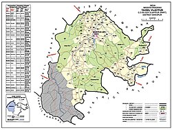

Kuno National Park

Kuno National Park was established as Kuno Wildlife Sanctuary in 1981 with an initial area of about 344.68 km2 (133.08 sq mi). One of the three gates to access this sanctuary, Pipalbawdi gate, is located near Agra, a village in Vijaypur. Most of the inhabitants were Saharia tribal people. An area of 924 km2 (357 sq mi) surrounding the wildlife sanctuary was added as a buffer zone to human settlements.

Siddh Baba Hill

This Divine hill is about 2 km from Bijeypur, on Morena-Shivpuri (M.S.) Road.. Every year in January and February, a trade fair is held. The initial part of the fair is dedicated to an animal fair in which people from nearby states come to selling and purchase animals like bulls, cows, camels etc. In the fair, cultural activities like kavi sammelan, folk songs, drama also take place.

Vijaypur Fort

At the bank of kwari river, stands a fort known as Vijaypur Fort. The fort was built by Vijay Singh, the King of Karauli and completed in the 14-15th century. Till this time Karauli used to border the state here. It is a protected monument of the state. The town was later named Vijaypur after Raja Vijay Singh.


Issues

See also


Related Research Articles

<span class="mw-page-title-main">Gwalior</span> Metropolis in Madhya Pradesh, India

Gwalior is a major city in the central Indian state of Madhya Pradesh; it lies in northern part of Madhya Pradesh and is one of the Counter-magnet cities. Located 343 kilometres (213 mi) south of Delhi, the capital city of India, 120 kilometres (75 mi) from Agra and 414 kilometres (257 mi) from Bhopal, the state capital, Gwalior occupies a strategic location in the Gird region of India. The historic city and its fortress have been ruled by several historic Indian kingdoms. From the Kachchhapaghatas in the 10th century, Tomars in the 13th century, it was passed on to the Mughal Empire, then to the Maratha in 1754, and the Scindia Dynasty of Maratha Empire in the 18th century. In April 2021, It was found that Gwalior had the best air quality index amongst the 4 major cities in Madhya Pradesh.

<span class="mw-page-title-main">Saharia</span> Adivasi tribe in north and central India

The Saharia, Sehariya, or Sahariya are an ethnic group in the state of Madhya Pradesh, India. The Saharias are mainly found in the districts of Morena, Sheopur, Bhind, Gwalior, Datia, Shivpuri, Vidisha and Guna districts of Madhya Pradesh and Baran district of Rajasthan.They are classified as Particularly vulnerable tribal group.

<span class="mw-page-title-main">Dholpur</span> City in Rajasthan, India

Dholpur is a city in the Dholpur district in Rajasthan state of India. It is situated on the left bank of the famous Chambal river. The city is the administrative headquarters of Dholpur District and was formerly seat of the Dholpur princely State of Jats.

<span class="mw-page-title-main">Sawai Madhopur district</span> District of Rajasthan in India

Sawai Madhopur district is a district of Rajasthan state in north-west India. Sawai Madhopur is the chief town and district headquarters. Sawai Madhopur district comes under Bharatpur division.

<span class="mw-page-title-main">Sheopur district</span> District of Madhya Pradesh in India

Sheopur District is a district of Madhya Pradesh state in central India. The district is located in the north of the state and forms part of Chambal division. It is situated on the periphery of Rajasthan, which shows in the influence of Rajasthani culture in this district.

<span class="mw-page-title-main">Bhind district</span> District of Madhya Pradesh in India

Bhind district is a district in the Chambal division of the Indian state of Madhya Pradesh. The town of Bhind is the district headquarters.Bhind District is situated in Chambal region in the northwest of the state. It is surrounded by Agra, Etawah, Jalaun and Jhansi districts of Uttar Pradesh state to the north and the east, and the Madhya Pradesh districts of Datia to the south, Gwalior to the southwest, and Morena to the west. The geography of the district is characterised by uneven ravines, plain fertile fields and scanty forests. The total area of the district is 4,459 km2 (1,722 sq mi).

<span class="mw-page-title-main">Shivpuri district</span> District of Madhya Pradesh in India

Shivpuri District is a district of Madhya Pradesh state of India. The town of Shivpuri is the district headquarters. National Highway 3 (NH-3) runs through the district.

<span class="mw-page-title-main">Sheopur</span> City in Madhya Pradesh, India

Sheopur is a city in Madhya Pradesh state of central India. It is the administrative headquarters of Sheopur District. Sheopur is linked by narrow gauge rail to Gwalior(No longer in operation). The town is traditionally famous for its wood carving. Chambal River is just 25 km, which forms the boundary between Rajasthan and MP states.

The Kwari River, also known as the Kuwari or Kunwari River, flows through the Sheopur, Morena and Bhind districts of Madhya Pradesh in central India. The total length of the river is approx 220 km.

<span class="mw-page-title-main">Karauli district</span> District of Rajasthan, India

Karauli District is a district of the state of Rajasthan in western India. It is located in the Braj Bhoomi region. The town of Karauli serves as the administrative headquarters of the district. Karauli district also comes under the Bharatpur Divisional Commissionerate.

Karera is a municipality or Nagar Parishad in the Shivpuri district of the Indian state of Madhya Pradesh.

Raghogarh-Ruthiyai or Raghogarh-Vijaypur is a town and municipality in Guna district in the Indian state of Madhya Pradesh.

Sabalgarh is a municipality in Morena district in the Indian state of Madhya Pradesh.

<span class="mw-page-title-main">Narsinghgarh, Rajgarh</span> Town in Madhya Pradesh, India

Narsinghgarh is a town and a municipality, near Rajgarh city in Rajgarh district in the Indian state of Madhya Pradesh.

<span class="mw-page-title-main">Dabra, Madhya Pradesh</span> Town in Madhya Pradesh, India

Dabra is a town and municipality in Gwalior district in the state of Madhya Pradesh, India located near NH-44 national highway. It serves the headquarters for both a tehsil and a coterminous community development block.

<span class="mw-page-title-main">Tourism in Madhya Pradesh</span> Overview of tourism in Madhya Pradesh, India

Tourism in Madhya Pradesh has been an attraction of India because of its location in the centre of the country. Madhya Pradesh has won Best Tourism State National award for 3 consecutive years i.e. 2017, 2016 and 2015.

<span class="mw-page-title-main">Flora and fauna of Madhya Pradesh</span>

Madhya Pradesh, often called the Heart of India, is a state in central India. Its capital is Bhopal. Madhya Pradesh was originally the largest state in India until November 1, 2000 when the state of Chhattisgarh was carved out. It borders the states Uttar Pradesh, Chhattisgarh, Maharashtra, Gujarat and Rajasthan.

The Kuno River is a prominent river that flows through the heart of the Kuno National Park from South to north in the Indian state of Madhya Pradesh. The river, which originates from the Vindhya mountain range, is a lifeline for the sanctuary's diverse flora and fauna.

<span class="mw-page-title-main">Hindaun Block</span> Subdistrict/Tehsil/Taluka in Rajasthan, India

Hindaun is a Block in Karauli district of the Indian state of Rajasthan in Northern India. It is a subdivisional headquarter. Its population is approximately 442,000. The block covers an area of 700 Square kilometres, which makes it the biggest block in Karauli. The subdistrict code of Hindaun Block is 00522. There are about 165 villages in Hindaun Block.

Atal Progress-Way, also known as Chambal Expressway, is an approved 404 km (251 mi) long, six-lane access-controlled greenfield expressway, which will connect the city of Kota in Rajasthan with the city of Etawah in Uttar Pradesh, through the famous city of Gwalior in Madhya Pradesh. It will pass through three states–Rajasthan, Madhya Pradesh and Uttar Pradesh. The expressway is a part of Bharatmala Pariyojana. The government's aim is to develop the economically backward regions of Chambal division and Gwalior division of Madhya Pradesh through the expressway. The expressway will reduce both travel time and distance, from 10-11 hours at present, to only 6-7 hours, and from 490 km (300 mi) to 404 km (251 mi). It will be built at a cost of approximately ₹ 23,700 crore, which was earlier slated at ₹ 20,000 crore. The expressway has been named as Atal Progress-Way after the former Prime Minister, Atal Bihari Vajpayee, and also because he was born in Gwalior, nearby which the expressway will pass.

References

  1. "Kuno Palpu sanctuary can house 60 Asiatic lions". Deccan Herald. Retrieved 8 December 2017.