Alampur, Madhya Pradesh

Last updated

Alampur
town
Madhya Pradesh location map.svg
Red pog.svg
Alampur
Location in Madhya Pradesh, India
Coordinates: 26°01′26″N78°47′08″E / 26.023753°N 78.785418°E / 26.023753; 78.785418
CountryFlag of India.svg  India
State Madhya Pradesh
District Bhind
Area
  Total12.11 km2 (4.68 sq mi)
Elevation
159 m (522 ft)
Population
 (2011)
  Total22,000
  Density1,800/km2 (4,700/sq mi)
Languages
  Official Bundelkhandi, Hindi
Time zone UTC+5:30 (IST)
PIN
477449
ISO 3166 code IN-MP
Vehicle registration MP

Alampur is a town and a nagar panchayat in Bhind district in the Indian state of Madhya Pradesh. Alampur is known for its history, for the chhatri of Malhar Rao Holkar which is in Alampur.

Contents

Geography

Alampur is located at 26°01′N78°47′E / 26.02°N 78.79°E / 26.02; 78.79 . [1] It has an average elevation of 159 metres (521 feet). It is 110 km from district headquarters Bhind. It is 100 km from Gwalior and 60 km from Datia.

Demographics

As of 2001 India census, [2] Alampur had a population of 9,350. Males constitute 54% of the population and females 46%. Alampur has an average literacy rate of 61%, higher than the national average of 59.5%: male literacy is 64%, and female literacy is 36%. In Alampur, 16% of the population is under 6 years of age.

Origin of the name

Alampur was built on the name of Alam Shah Pavar who came here as the governor of province. No one knows about the origin of the Alampur Fortress but we can make supposition according to its architecture that this must have been built around the 14-15th century.

History

Malhar Rao Holkar's Chhatrisamadhi, built by his daughter-in-law Maharani Ahilya Bai Holkar, at Alampur Chhatri of Malhar Rao Holkar at Alampur, India.jpg
Malhar Rao Holkar's Chhatri samadhi, built by his daughter-in-law Maharani Ahilya Bai Holkar, at Alampur
Back view of Malhar Rao Holkar's Chhatrisamadhi at Alampur Back View of Chhatri at Alampur.jpg
Back view of Malhar Rao Holkar's Chhatri samadhi at Alampur

Alampur is a historical town. It was a tehsil in Indore state. It is holy land of Malhar Rao Holkar and Ahilyabai Holkar. There is an ancient chhatri of Malhar Rao Holkar and a Fortress at Alampur.

Holkar state.jpg


Alampur Pargana

Alampur was a small, isolated pargana belonging to Indore State but situated in the Bundelkhand Agency, Central India, with an area of 37 square miles, lying round the town of Alampur. The pargana was formed in 1766 when Malhar Rao Holkar, the founder of the house of Indore, died suddenly at the village of Alampur. To provide for the upkeep of his last resting place, 27 villages were obtained from the neighbouring chiefs of Gwalior, Datia, Jalaun, and Jhansi, and their revenues devoted to this purpose. The Rajput chiefs, from whom the villages were probably taken by force, were long opposed to the erection of the dead Maharaja's cenotaph, and destroyed it several times; finally, however, with the support of Sindhia the work was finished. The pargana was managed directly from Indore, and yielded a revenue of Rs. 59,000. The population in 1901 was 16,711, compared with 17,038 in 1891. There were 26 villages in the pargana. The largest is Alampur, also called Malharnagar, with a population (1901) of 2,843. A school, a dispensary, and a British post office were situated here.

Chhatri

Maharani Ahilya Bai Holkar built the chhatri of Malhar Rao Holkar at Alampur in Bhind district in 1766 A.D. Built on the pattern of the chhatris of Holkar rulers at Indore, the chhatri is famous for its carvings of floral and leaf patterns. The Maratha style chhatri represents a blend of shikhar dome and arch, on which Kalash has been made. The first storey of the chhatri is a pillared hall decorated with paintings. This canopy is located on the left side of the entrance of Alampur. In 1766, Malhar rao Holkar camped here during the battle with Jaat Rulers during which he died here and a canopy was built here in his memory and it is currently known as Malhar Rao Holkar Chhatri. Chatri is built on a 6-foot-high scaffold with a sanctorum in the middle and encompass a path around it founded on the pillars. Colorful carvings are on the roof of the encompassing path and vines are carved on the walls of sanctorum inspired by Iranian Style. Carvings are also on the balcony of the sanctorum (गर्भगृह) with sun on the middle of the north, east and south and a tortoise on the west balcony. Sanctorium remain above the main peak which is oval in shape amra vase (आम्र कलश) at its top. Several other peaks are around the main peak. The sanctorum also has windows all around. The wall on the left side of the canopy has statues of the ruling family with five panels of such. Some statues are also there on the walls of the canopy. At present a trust is looking after the Chhatri.

Fortress

No one knows about the origin of the Alampur Fortress but one can make supposition according to its architecture that it must have been built around the 14-15th century. There are two entrances, one east and other one north. The door at the east was the main entrance of the fortress, and it seems that the door at the north was built later. The ramparts of the fortress are damaged at present but it can be supposed that the fortress was very strong in the past. Shala Bhavan inside the fortress which looks similar to darbaar[ what language is this? ] has cracks in many places but can be reinforced again after little maintenance. Currently a trust office is running at the second Building which is in good condition; possibly this was the residence of the governor of the province. A shrine and a Shiv temple are situated just in front of this building.

Other historical temples, monuments, and sites in Alampur

Harihareshwar (Badi Mata) temple, Murli Manohar Mandir,Batuk, Malharimarthand, Surya, Renuka, Ram Hanuman Temples, Shriram Temple, Laxmi Narayan Temple, Maruti Temple, Narsinh Temple, Khanderao Martand Temple, Memorial of Malhar Rao.

People and culture

There is a large number of Hindus in Alampur, and Muslims also live here. Alampur is a historical town and Maharani Ahilyabai Holkar built many temples in Alampur. Major festivals are Holi, Diwali, Eid, Christmas and Raksha bandhan. Alampur is also in Bundelkhand, so there is effect of Bundelkhand's culture in Alampur.

Administration

Alampur was governed by a municipality (nagar panchayat) under the Madhya Pradesh municipality act in 1978. There are 15 wards in nagar panchayat Alampur.

Education

According to the census of 2001, there are 5,700 literate people in Alampur.

Educational institutions

Agriculture and business

There is a Krisi Upaj Mandi that is one of the six Krishi Upaj Mandies in Bhind district.

Banks

National banks

Other banks

Excursions

Related Research Articles

<span class="mw-page-title-main">Indore</span> Metropolitan city in Madhya Pradesh, India

Indore is the largest and most populous city in the Indian state of Madhya Pradesh. It is consistently ranked as the cleanest city in India. It serves as the headquarters of both the Indore District and the Indore Division. It is also considered as the state education hub and houses campuses of both the Indian Institute of Technology and the Indian Institute of Management. Located on the southern edge of Malwa Plateau, at an average altitude of 553 meters (1,814 ft) above sea level, it has the highest elevation among major cities of Central India. The city is 190 km (120 mi) west of the state capital of Bhopal. It is 57 km (35 mi) from Ujjain and 35 km (20 mi) from Dewas. Indore had a census-estimated 2011 population of 1,994,397 and 3,570,295. The city is distributed over a land area of just 530 square kilometres (200 sq mi), making Indore the most densely populated major city in the central province.

<span class="mw-page-title-main">Central India Agency</span> Agency of princely states in India

The Central India Agency was created in 1854, by amalgamating the Western Malwa Agency with other smaller political offices which formerly reported to the Governor-General of India. The agency was overseen by a political agent who maintained relations of the Government of India with the princely states and influence over them on behalf of the Governor-General. The headquarters of the agent were at Indore.

<span class="mw-page-title-main">Dewas</span> City in Madhya Pradesh, India

Dewas is a city in the Malwa region of the Indian state of Madhya Pradesh. The municipality was formerly the seat of two 15-Gun Salute state princely states during the British Raj, Dewas Junior state and Dewas Senior state, ruled by the Pawar clan of the Marathas. The city is the administrative capital of Dewas district. Dewas is an industrialised city and houses a government bank note press.

<span class="mw-page-title-main">Datia</span> City in Madhya Pradesh, India


Datia is the district headquarter of the Datia District in north central Madhya Pradesh,a state of Central India. It is an ancient town, mentioned in the Mahabharata ruled by King Dantavakra. The city is 78 km from Gwalior, 325 km south of New Delhi and 344 km north of Bhopal. About 18 km from Datia is Sonagiri, a sacred Jain hill. Datia is also about 31 km from Jhansi and 52 km from Orchha. The nearest airport is at Gwalior. It was formerly the seat of the eponymous princely state in the British Raj. Datia is situated near Gwalior and on the border with Uttar Pradesh.

<span class="mw-page-title-main">Maheshwar</span> Town in Madhya Pradesh, India

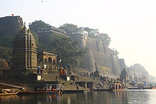
Maheshwar is a town, near Khargone city in Khargone district of Madhya Pradesh state, in central India. It is located on State Highway-38 ,13.5 km east of National Highway 3 and 91 km from Indore, the commercial capital of the state. The Town lies on the north bank of the Narmada River. It was the kingdom of Chaktavartin Samrat Sahastraarjun, Kartavirya Arjuna a Heheya king. Lately, after many years, it was the capital of the Malwa during the Maratha Holkar reign till 6 January 1818, when the capital was shifted to Indore by Malhar Rao Holkar III.

<span class="mw-page-title-main">Holkar</span> Dhangar clan in India

The Holkars were a family that was part of the Maratha Empire, which held the rank of subahdar under Peshwa Baji Rao I. When the Maratha Empire began to weaken due to internal clashes, the Holkars declared themselves the rulers of Indore in Central India, existing as an autonomous member of the Maratha Empire until 1818. Later, their kingdom became a princely state under the protectorate of British India.

<span class="mw-page-title-main">Chhatri</span> Elevated, dome-shaped pavilions in Indian architecture

Chhatri are semi-open, elevated, dome-shaped pavilions used as an element in Indo-Islamic architecture and Indian architecture. They are most commonly square, octagonal, and round. Originating as a canopy above tombs, they largely serve as decorative elements as opposed to functional elements. The earliest examples of chhatri being used in the Indian Subcontinent were found in the Shrine of Ibrahim in Bhadreswar, constructed between 1159 and 1175 AD.

<span class="mw-page-title-main">Ahilyabai Holkar</span> Ruler of Indore from 1767 to 1795

Ahilyabai Holkar was the Rani of Indore, within the Maratha Confederacy. She established Maheshwar as the seat of the Holkar Dynasty.

Kanad is a town and a nagar parishad in Agar Malwa district in the Indian state of Madhya Pradesh. It comes under Kanad Parishad. It belongs to Ujjain Division. It is situated along the Agar–Sarangpur SH-41 highway. It is located 18 km (11 mi) towards east from the district headquarters of Agar Malwa, 83 km (52 mi) from Ujjain, 186 km (116 mi) from the state capital of Bhopal.

<span class="mw-page-title-main">Grishneshwar Temple</span> Shrine dedicated to Lord Shiva

Grushneshwar Jyotirlinga Mandir or Grushneshwar is a Jyotirlinga mandir of Shiva in Verul village of Sambhajinagar district, Maharashtra. It is one of the 12 Jyotirlinga mandirs.

<span class="mw-page-title-main">Bhind district</span> District of Madhya Pradesh in India

Bhind district is a district in the Chambal division of the Indian state of Madhya Pradesh. The town of Bhind is the district headquarters. Bhind District is situated in Chambal region in the northwest of the state. It is bounded by Agra, Etawah, Jalaun and Jhansi districts of Uttar Pradesh state to the north and the east, and the Madhya Pradesh districts of Datia to the south, Gwalior to the southwest, and Morena to the west. The geography of the district is characterised by uneven ravines, plain fertile fields and scanty forests. The total area of the district is 4,459 km2 (1,722 sq mi).

<span class="mw-page-title-main">Kumher</span> Town in Rajasthan, India

Kumher is a historical town and land of Yaduvanshi Sinsinwars the initial name of this town was Kuber. It is located in Deeg District of Rajasthan, India.

<span class="mw-page-title-main">Malhar Rao Holkar</span> First Maharaja of Indore from 1731–1766

Malhar Rao Holkar was a noble subedar of the Maratha Empire, in present-day India. He was one of the early officers along with Ranoji Scindia to help spread the Maratha rule to northern states and was given the estate of Indore to rule by the Peshwas, during the reign of the Maratha emperor Shahu I. He was founder of the Holkar dynasty that ruled Malwa.

<span class="mw-page-title-main">Bundelkhand Agency</span>

The Bundelkhand Agency was a political agency of the British Raj, managing the relations of the British government with the protected princely states of the Bundelkhand region.

<span class="mw-page-title-main">Gwalior Residency</span> Gwalior State political office

Gwalior Residency was a political office in the British Indian Empire, which existed from 1782 until the British withdrawal from India in 1947.

Karera is a municipality or Nagar Parishad in the Shivpuri district of the Indian state of Madhya Pradesh.

<span class="mw-page-title-main">Pitambara Peeth</span> Hindu temple in Madhya Pradesh, India

Shri Peetambra Peetha is a complex of Hindu temples, located in the city of Datia, in the Madhya Pradesh state of central India. It was, according to many legends 'Tapasthali' of many mythological as well as real life people. The Shivling of shree Vankhandeswar Shiva is tested and approved by the Archaeological Survey of India to be of the same age as that of the Mahabharata. It is primarily a Shaktipeeth place of worship . Many people come here for worship on Saturday, there is the biggest crowd here.

<span class="mw-page-title-main">Rao Nandlal Chaudhary</span>

Rao Nandlal Chaudhary was the chief of the Zamindars of Kampel, near Indore. He was a Gaur Brahmin. Under the suzerainty of the Mughals, he controlled Kampel and some of its surrounding area including Indore. He accepted the suzerainty of the Marathas, after the Nizam acceded to the Peshwa's demands in 1724.

Khanderao Holkar was the only son of Malhar Rao Holkar, the founder of the Holkar dynasty of Indore, and Gautama Bai. He was the husband of Ahilyabai Holkar. He served as a Maratha Sardar and fought several campaigns on behest of the Maratha empire.

<span class="mw-page-title-main">Krishnapura Chhatri</span> Memorial in Indore, India

The Krishnapura Chhatris, also known as the Krishna Pura Chhatris are three chhatris located in Indore, Madhya Pradesh, India. The structures were built by the Holkars as cenotaphs over the spots where people of importance were cremated, leading to them also being known as the Holkar Chhatris. All three of the Chhatris are located half a kilometer from the city palace, Rajwada, which was also built by the Holkar dynasty.

References

  1. Falling Rain Genomics, Inc - alampur
  2. "Census of India 2001: Data from the 2001 Census, including cities, villages and towns (Provisional)". Census Commission of India. Archived from the original on 16 June 2004. Retrieved 1 November 2008.