Related Research Articles

The Arctic Archipelago, also known as the Canadian Arctic Archipelago, is an archipelago lying to the north of the Canadian continental mainland, excluding Greenland.
Troitsk is the name of several inhabited localities in Russia.
Goldberg-Mildenitz is an Amt in the Ludwigslust-Parchim district, in Mecklenburg-Vorpommern, Germany. The seat of the Amt is in Goldberg.
Ramrai village is known for holy place because of lord rama's arrivalJind district of the state of Haryana, India. It is located on the Jind-Hansi road, 9 kilometres (5.6 mi) west of Jind. Ramrai is a traditional south-west Yaksha of the Kurukshetra region.
Həziabad is a village and municipality in the Jalilabad Rayon of Azerbaijan. It has a population of 1,725.
Domkowo is a village in the administrative district of Gmina Grunwald, within Ostróda County, Warmian-Masurian Voivodeship, in northern Poland. It lies approximately 17 kilometres (11 mi) south-east of Ostróda and 38 km (24 mi) south-west of the regional capital Olsztyn.

Chengalpattu is a state assembly constituency in Kancheepuram district, Tamil Nadu, India. Its State Assembly Constituency number is 32. It comprises a portion of Chengalpattu taluk and is a part of the Kancheepuram constituency for national elections to the Parliament of India. It is one of the 234 State Legislative Assembly Constituencies in Tamil Nadu, in India.

Marechal Cândido Rondon is a municipality in the state of Paraná in the Southern Region of Brazil.
Ogalur is a village in Perambalur district, Tamil Nadu, India. It was formerly in Tiruchirappalli district.
Kellavere is a village in Vinni Parish, Lääne-Viru County, in northeastern Estonia. Between 1992 and 2017 the village was located in Laekvere Parish.
Ohulepa is a village in Rapla Parish, Rapla County in northwestern Estonia.
Gahlai is a village in Jaunpur, Uttar Pradesh, India. It is home of the famous temple Durgadevi which is situated on bank of River Basuhi. Every Tuesday thousands of people come there for prayer and to enjoy the fair.
Ajdinovići is a village in the municipality of Višegrad, Bosnia and Herzegovina.

Bajpatti Assembly constituency is an assembly constituency in Sitamarhi district in the Indian state of Bihar.
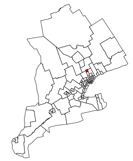
Newmarket—Aurora is a provincial electoral district in Ontario, Canada, that has been represented in the Legislative Assembly of Ontario since 2007.
Sansa is a village in Aurangabad district, Bihar, India,. The village is situated on the road joining Daudnagar to Haspura.
Akhtachi Rural District is a rural district (dehestan) in the Central District of Bukan County, West Azerbaijan Province, Iran. At the 2006 census, its population was 7,050, in 1,232 families. The rural district has 27 villages. A village in Akhtachi Rural District is Kani Tumar.
Padena-ye Vosta Rural District is a rural district (dehestan) in Padena District, Semirom County, Isfahan Province, Iran. At the 2006 census, its population was 5,435, in 1,327 families. The rural district has 11 villages.
Bajajnagar is a census town in the Mavli tehsil of Udaipur district, Rajasthan, India. It is situated around 18km away from Mavli and 25km away from district headquarter Udaipur.
Patsoi Legislative Assembly constituency is one of the 60 Legislative Assembly constituencies of Manipur state in India
References
- ↑ Election Commission of India (2002). "State Elections 2002" (Text/HTML). List of Contesting Candidates. Government of India . Retrieved 26 August 2010.
Coordinates: 24°34′N79°04′E / 24.567°N 79.067°E
| | This Allahabad district location article is a stub. You can help Wikipedia by expanding it. |