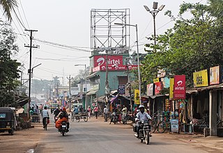
Nongpoh is the administrative centre of Ri-Bhoi district in the Indian state of Meghalaya in the Republic of India. Nongpoh is located on National Highway 40, fifty-two kilometers from the state capital Shillong and forty-eight kilometers from Guwahati in the state of Assam.
Khagaria is a city in Indian state of Bihar and the administrative headquarters of Khagaria district. Khagaria is a part of Munger division. It is located at 25.5°N 86.48°E and has an average elevation of 36 metres (118 feet). The Khagaria Junction railway station serves the city.It is situated about 25 km north of Munger.

Gyanpur is a town and a nagar panchayat in Bhadohi district in the Indian state of Uttar Pradesh and the administrative headquarters of Bhadohi district.

Angul is a town and a municipality and the headquarters of Angul district in the state of Odisha, India. Angul has an average elevation of 195 m (640 ft) above sea level. The total geographical area of the district is 6232 km2. From the point of view of area, it stands 11th among the 30 Districts of Odisha.
Etmadpur is a town (tehsil) in Agra district in the state of Uttar Pradesh, India. It is located eastward 19 km from Agra. It is 274 km far from state capital Lucknow.
Gulaothi is a town, near Bulandshahr city in the Bulandshahr district that falls under the Meerut division of the Indian state of Uttar Pradesh.
Handia is a town, near the city of Prayagraj and a nagar panchayat in the Prayagraj district of the Indian state of Uttar Pradesh.
Jalalpur is a town, tehsil and a municipal board in Ambedkar Nagar district in the Indian state of Uttar Pradesh, India.
Kachhwa is a town and a nagar panchayat in Mirzapur district in the Indian state of Uttar Pradesh.

Kadipur is a town, tehsil and a nagar panchayat in Sultanpur district in the Indian state of Uttar Pradesh. It is located a short distance from the bank of the Gomti River, at a crossroads between two roads heading from Sultanpur to Surapur and from Pratapgarh to Dostpur and then on to Akbarpur. On the north side of town is a stream with a steep ravine that drains the surrounding area. The road to Sultanpur crosses over this stream on a bridge. The lands surrounding Kadipur are average quality for agricultural purposes. As of 2011, Kadipur has a population of 8,010 people, in 1,216 households.

Khallikote is a town and a Notified Area Council in Ganjam district in the Indian state of Odisha.
Khandapada is a town and a notified area committee in Nayagarh district in the Indian state of Odisha. It is located in the valley of nine mountains.

Khatima is a city and a municipal board in Udham Singh Nagar district in the Indian state of Uttarakhand.
Nimapada is a town and a Notified Area Council (NAC) in Puri district on the way to Konark and 40 km from the state capital Bhubaneswar in the Indian state of Odisha.
Phulpur is a town and a nagar panchayat in Azamgarh district in the Indian state of Uttar Pradesh.

Pipili is a town and a NAC under jurisdiction of Puri district in the Indian state of Odisha. It is famous for designing beautiful Applique handicrafts. It is a town of artisans famous for their colourful fabrics.
Vedasanthoor is a panchayat town in Dindigul district Located at Indian state of Tamil Nadu. Vedasanthoor town is 21 km (13 mi) from Dindigul city, 25 km (16 mi) from Oddanchatram town, and 82 km (51 mi) from Madurai.
Goshainganj, also known as Gosainganj, is a town and nagar panchayat in the Faizabad district of the Indian state of Uttar Pradesh. Located 32 km from the district headquarters Ayodhya, Goshainganj has one of the oldest markets of the district.

Bramhapuri is a town and municipal council in Chandrapur district in the state of Maharashtra, India.
Heirok is a town and a nagar panchayat in Thoubal district in the Indian state of Manipur.


