Hathras

Last updated

Hathras
City
Banke Bhawan Residance of Kaka Hathrasi.jpg
Banke Bhawan, residence of poet Kaka Hathrasi
Nickname: 
Asafoetida City
India Uttar Pradesh location map.svg
Red pog.svg
Hathras
India location map.svg
Red pog.svg
Hathras
Coordinates: 27°36′N78°03′E / 27.60°N 78.05°E / 27.60; 78.05
CountryFlag of India.svg  India
State Uttar Pradesh
Division Aligarh
District Hathras
Government
  Type Municipal Council
  BodyHathras Municipal Council
  Municipal ChairpersonShweta Chaudhary [1] [2] (BJP)
   MLA Anjula Singh Mahaur (BJP)
Area
  Total142 km2 (55 sq mi)
Elevation
178 m (584 ft)
Population
 (2011)
  Total160,909
Languages
  Official Hindi, Urdu
Time zone UTC+5:30 (IST)
PIN
204101
Telephone code05722
Vehicle registration UP-86
Sex ratio 870 /
Website hathras.nic.in

Hathras is a historical city in Uttar Pradesh, India. It is the headquarters of Hathras district, formed on 3 May 1997 by merging parts of Aligarh, Mathura and Agra. It is part of the Aligarh Division. [3]

Contents

A temple in Hathras Hathras temple.jpg
A temple in Hathras

The primary spoken language is a dialect of Hindi, Braj Bhasha, which is closely related to Khariboli, one of several dialects spoken in the Delhi region. [4] It is known for production of asafoetida (aka hing). [5]

Administration

Hathras is a district headquarter with four subdivisions - Hathras, sasni, Sikandra Rao, and Sadabad. It is a Lok Sabha constituency under the reserved category of Schedule Caste. The district has three assembly constituencies, following three subdivisions. The Hathras district, formerly known as Mahamaya Nagar, was created in 1997 with the incorporation of parts of the Aligarh, Mathura, and Agra districts. [6]

Local bodies

Hathras has nine local bodies: [7]

Geography

Hathras is located at 27°36′N78°03′E / 27.6°N 78.05°E / 27.6; 78.05 . [9] It has an average elevation of 185 metres (606 feet) and is situated on the Agra, Aligarh and Mathura, and Bareilly highway crossings. It is known for its extreme temperature variations. [10] As of the 2001 Indian census, Hathras had a population of 123,243, of which 53% were male and 47% female. Hathras has an average literacy rate of 60%, higher than the national average of 59.5%, of which 66% being male and 53% being female. 14% of the population is under six years of age.

CityDistance from Hathras townDirection from Hathras town
Aligarh 36 kmTowards the north
Mathura 41 kmTowards the west
Khair 46 kmTowards the northwest
Agra 53.8 kmTowards the south

Climate

Hathras has a monsoon-influenced humid subtropical climate, typical of north-central India. Summers start in April ending around May. The monsoon season starts in late June, continuing until early October, bringing high humidity. [11]

Climate data for Hathras
MonthJanFebMarAprMayJunJulAugSepOctNovDecYear
Mean daily maximum °F (°C)71.6
(22.0)
82.0
(27.8)
92.1
(33.4)
102.2
(39.0)
108.7
(42.6)
104.0
(40.0)
95.0
(35.0)
93.2
(34.0)
96.6
(35.9)
94.1
(34.5)
73.4
(23.0)
76.1
(24.5)
114.1
(45.6)
Mean daily minimum °F (°C)42.1
(5.6)
53.6
(12.0)
62.8
(17.1)
72.3
(22.4)
82.0
(27.8)
85.1
(29.5)
81.0
(27.2)
78.8
(26.0)
70.7
(21.5)
73.4
(23.0)
50.2
(10.1)
44.6
(7.0)
45.5
(7.5)
Source: India Meteorological Department [12] [13]

Transport

Four railway stations serve Hathras: Hathras Junction railway station, Hathras Road railway station, [14] Hathras City railway station, and Hathras Kila railway station. A new station on the dedicated Freight Corridor Line was named New Hathras.

Hathras is the only city in the area to have five railway stations named after it.

History

At the end of the 18th century the town of Hathras was held by a Jat chieftain, whose fort stood at the east end of the town, and was annexed by the British in 1803, who besieged the fort in 1817. Under British rule, Hathras rapidly rose to commercial importance, and for a while ranked second to Cawnpore (now Kanpur) among the trading centres of the Doab. [15]

Hathras became a district on 6 May 1997 with the merging of some Tehsils of Aligarh and Mathura. [16] Hathras falls under the Braj region of Northern India and is famous for its industrial, literary, and cultural activities as a part of Aligarh. It has been an industrial centre since the British Raj era.

Notable people

Related Research Articles

<span class="mw-page-title-main">Aligarh</span> City in Uttar Pradesh, India

Aligarh is a city in the state of Uttar Pradesh in India. It is the administrative headquarters of Aligarh district, and lies 342 kilometres (213 mi) northwest of state capital Lucknow and approximately 130 kilometres (81 mi) southeast of the capital, New Delhi. The cities and districts which adjoin Aligarh are: Gautam Buddha Nagar, Bulandshahr, Sambhal, Badaun, Kasganj, Hathras, Etah and Mathura. As of 2011, Aligarh is the 53rd most populous city in India.

<span class="mw-page-title-main">Braj</span> Region in India

Braj, also known as Vraj, Vraja, Brij or Brijbhumi, is a region in India on both sides of the Yamuna river with its centre at Mathura-Vrindavan in Uttar Pradesh state encompassing the area which also includes Palwal, Ballabhgarh and Nuh in Haryana state, Deeg, Bharatpur, Karauli, and Dholpur in Rajasthan state and Morena District in Madhya Pradesh. Within Uttar Pradesh, it is very well demarcated culturally, the area stretches from the Mathura, Aligarh, Agra, Hathras and districts up to the Farrukhabad, Mainpuri and Etah districts. Braj region is associated with Radha and Krishna who according to scriptures were born in Barsana and Mathura respectively. It is the main centre of Krishna circuit of Hindu pilgrimage.

<span class="mw-page-title-main">Agra division</span> Administrative division of Uttar Pradesh, India

Agra division is one of the 18 administrative geographical units of the northern Indian state of Uttar Pradesh. It contains 4 districts i.e. Agra, Firozabad, Mainpuri and Mathura districts. The population of Agra Division was 11,304,646 as of 2011 census. Agra city is the headquarters of this division.

<span class="mw-page-title-main">Firozabad</span> City in Uttar Pradesh, India

Firozabad is a city near Agra in Firozabad district in the state of Uttar Pradesh in India. It is the centre of India's glassmaking industry and is known for the quality of the bangles and glassware produced here.

<span class="mw-page-title-main">Braj Bhasha</span> Western Hindi language of India

The Braj language, Braj Bhasha, also known as Vraj Bhasha or Brij Bhasha or Braj Boli, is a Western Hindi language. Along with Awadhi, it was one of the two predominant literary languages of North-Central India before the switch to Hindustani in the 19th century.

<span class="mw-page-title-main">Aligarh district</span> District in Uttar Pradesh, India

Aligarh is one of the 75 districts in the northern Indian state of Uttar Pradesh. This district is a part of Aligarh Division. The districts which adjoin Aligarh are Gautam Buddha Nagar, Bulandshahr, Sambhal, Badaun, Kasganj, Hathras and Mathura.

<span class="mw-page-title-main">Etah district</span> District of Uttar Pradesh in India

Etah district is one of the districts of Uttar Pradesh, India, since 1854. Etah City is the district headquarters. Etah district is a part of Aligarh Division.

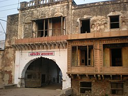
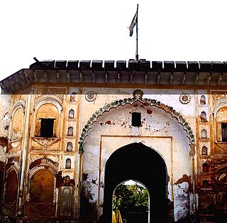
Mursan is a town and a Nagar Panchayat in Hathras district in the Indian state of Uttar Pradesh. The primary spoken language is a dialect of Hindi, Braj Bhasha, which is closely related to Khariboli. In past, Raja Mahendra Pratap Singh was the ruler of Mursan. At present, the Chairman of Mursan is Deshraj Singh. Former Chairmen of Mursan:

<span class="mw-page-title-main">Firozabad district</span> District of Uttar Pradesh in India

Firozabad district is one of the western districts of the Indian state of Uttar Pradesh, which has Firozabad city as its district headquarters. The district is a part of the Agra division.

<span class="mw-page-title-main">Hathras district</span> District of Uttar Pradesh in India

Hathras district is a district of Uttar Pradesh state of India. The city of Hathras is the district headquarters. Hathras district is a part of Aligarh division. The district occupies an area of 1,840 square kilometres (710 sq mi) and has a population of 1,564,708 as of the 2011 census.

<span class="mw-page-title-main">Mathura district</span> District of Uttar Pradesh in India

Mathura district situated along the banks of the river Yamuna is a district of Uttar Pradesh state of north-central India. The historic city of Mathura is the district headquarters. Mathura district is home to many important sites associated with goddess Radha and Lord Krishna, who was born in Mathura and grew up in the nearby town of Vrindavan. Both cities are some of the most sacred sites in the Vaishnava tradition, making Mathura district an important Hindu pilgrimage centre.

Beswan is a town and a nagar panchayat in Aligarh district in the state of Uttar Pradesh, India. Beswan was a jagir which was ruled by Thenua Jats.

Paid Service in Iglas-8279370710

<span class="mw-page-title-main">Sadabad, India</span> Town in Uttar Pradesh, India

Sadabad is a town and a nagar panchayat in Hathras district in the Indian state of Uttar Pradesh.

Sikandra Rao is a town in Hathras district of Uttar Pradesh. It is one of the three assembly constituencies of the district and a Municipal board. The current MLA from the constituency is senior BJP leader Birendra Singh Rana.The town is connected to the cities of Aligarh and Etah by NH-34 and to the city of Agra by NH-21. The nearest airport is Agra Airport.

<span class="mw-page-title-main">Western Uttar Pradesh</span> Region in northern India

Western Uttar Pradesh is a region in India that comprises the western districts of Uttar Pradesh state, including the areas of Rohilkhand and those where Khadiboli and Braj Bhasha are spoken. The region has some demographic, economic and cultural patterns that are distinct from other parts of Uttar Pradesh, and more closely resemble those of Haryana and Rajasthan states. Western Uttar Pradesh has experienced rapid economic growth, in a fashion similar to Haryana and Punjab, due to the successes of the Green Revolution. A significant part of western Uttar Pradesh is a part of National Capital Region of India. The largest city of the region is Ghaziabad, while the second-largest city, Agra, is a major tourist destination.

<span class="mw-page-title-main">Hathras Junction railway station</span> Railway station in Uttar Pradesh, India

Hathras Junction railway station is on the Kanpur–Delhi section of Howrah–Delhi main line and Howrah–Gaya–Delhi line. It is located in Hathras district in the Indian state of Uttar Pradesh. It serves Hathras and surrounding areas.

Hasanpur Baru is a Village and a Gram Panchayat in Hathras district in the Indian state of Uttar Pradesh. A part of the Braj region, it is located in Sadabad Tehsil, in Aligarh Division.

Mai is a village in Sadabad Block in Mahamaya Nagar District of Uttar Pradesh State, India. It belongs to Aligarh Division. It is located 40 km towards the South of the District headquarters Hathras and 16 km from Sadabad. 350 km from the State capital Lucknow. Mai Pin code is 281306 and the postal head office is Sadabad. Chirawali, Saroth, Ghooncha, Nanau, Garhumrao, Nagla Banarasi are the nearby Villages to Mai. Mai is surrounded by Khandauli Block towards the East, Baldeo Block towards the west, Agra Block towards the South, and Sehpau Block towards the East.

References

  1. "2023 UP Municipal Election results". ECI Uttar Pradesh. Retrieved 22 May 2023.
  2. "BJP's Shweta Chaudhary wins Hathras Municipal Council Chairman seat; defeats SP's Lallan Singh". Amar Ujala. Retrieved 22 May 2023.
  3. "Akhilesh renames eight districts". Thehindu.com. 24 July 2012. Retrieved 6 January 2019.
  4. Scott, Jerrie Cobb; Straker, Dolores Y.; Katz, Laurie (2 June 2009). Affirming Students' Right to Their Own Language: Bridging Language Policies and Pedagogical Practices. Routledge. ISBN   978-1-135-26945-6.
  5. "Official Website of One District One Product Uttar Pradesh / Hathras". odopup.in. Retrieved 31 July 2020.
  6. "Administrative Setup | District Hathras, Government of Uttar Pradesh | India" . Retrieved 13 May 2020.
  7. "LOCAL BODIES | District Hathras, Government of Uttar Pradesh | India" . Retrieved 4 June 2020.
  8. "LOCAL BODIES | District Hathras, Government of Uttar Pradesh | India".
  9. "Falling Rain Genomics, Inc - Hathras". Fallingrain.com. Retrieved 23 June 2012.
  10. "Weather for Hathras, Uttar Pradesh, India". Timeanddate.com. Retrieved 6 January 2019.
  11. "Hathras Monthly Climate Averages". WorldWeatherOnline.com. Retrieved 16 August 2020.
  12. "Extremes of Temperature & Rainfall for Indian Stations (Up to 2012)". India Meteorological Department. December 2019. p. M210. Archived from the original on 5 February 2020. Retrieved 27 April 2020.
  13. "Extremes of Temperature (From Jan 2020 to Aug 2020)". India Meteorological Department. 16 August 2020. p. M210. Archived from the original on 16 August 2020. Retrieved 16 August 2020.
  14. "Hathras Road Railway Station (HTJ) : Station Code, Time Table, Map, Enquiry". www.ndtv.com. Retrieved 25 May 2020.
  15. Wikisource-logo.svg One or more of the preceding sentences incorporates text from a publication now in the public domain :  Chisholm, Hugh, ed. (1911). "Hathras". Encyclopædia Britannica . Vol. 13 (11th ed.). Cambridge University Press. p. 63.
  16. "About District | District Hathras, Government of Uttar Pradesh | India" . Retrieved 25 May 2020.
  17. "Raja mahendra Pratap Singh". BBC . Retrieved 3 July 2022.
  18. "About District | District Hathras, Government of Uttar Pradesh | India".