
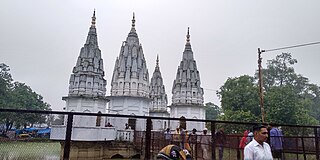
Bithoor or Bithur is a town in Kanpur district, 23.4 kilometres (14.5 mi) by road north of the centre of Kanpur city, in Uttar Pradesh, India. Bithoor is situated on the right bank of the River Ganges, and is a centre of Hindu pilgrimage. Bithoor is also the centre for War of Independence of 1857 as Nana Sahib, a popular freedom fighter who was based there. The city is enlisted as a municipality of Kanpur metropolitan area.

Kanpur division is one of the 18 administrative geographical units of the northern Indian state of Uttar Pradesh. Kanpur city is the administrative headquarters of the division. Kanpur was formerly spelled Cawnpore. The division consists of 6 districts:-
Kannauj district is an administrative district of Uttar Pradesh state in northern India, along the river Ganges. The historic town of Kannauj, northwest of Kanpur, is the administrative center. The district was carved out of Farrukhabad district on 18 September 1997. The native dialect of this district is Kannauji.
Bakewar is a town and a nagar panchayat in Etawah district in the state of Uttar Pradesh, India. It is 22 km from district headquarters Etawah. Bakewar is famous for its very good education system, Agriculture Training Institute and for National highway no. 2. Bakewar is situated at national highway no. 2. It is between Agra and Kanpur, the two biggest cities of Uttar Pradesh. Agra is 145 km north and Kanpur is 135 km on south of Bakewar. Bharthana is the nearest railway (11 km) of Bakewar, situated in the east.
Bhander is a town and a nagar panchayat in Datia district in the state of Madhya Pradesh.

Chakeri is a census town in Kanpur metropolitan area, situated about 16 kilometres east of Kanpur city in the state of Uttar Pradesh, India. It is an industrial town with textiles and food products as its major productions. Chakeri Airforce Station, North India's second-largest air force base is situated here. Chakeri is home to reputed educational institutions and colleges. Central Leather Research Institute, the only government leather research institute in North India is situated here. The Grand Trunk Road made by emperor Sher Shah Suri passes through Chakeri. The town is enlisted as a town area of the Kanpur metropolitan area.
Ekdil is a town and a nagar panchayat in Etawah district in the state of Uttar Pradesh, India. This place was established by the Ekdil Khan. It was earlier known as Sarai Rupa. In the 17th century, a eunuch named Ekdil Khan came here, and built a new sarai, which he named Ekdil. At the Time of Mahabharata, Present Day Ekdil was part of Ishtikapuri. It is 9 kilometers from Etawah). It has a small railway station on the north side, 3 kilometers town.It lies between Yamuna At its south around 10km and Ganga river at its North around 50km. It has majority population of 79% of Hindus and compromise approx 21% of Muslims.
Kamalganj is a town and a nagar panchayat in Farrukhabad district in the Indian state of Uttar Pradesh. The town is one of the key contributors to Potato production in the district. Kamalganj was named after Muslim religion promoter and social worker 'Kamal Baba'.
Karera is a municipality or Nagar Parishad in the Shivpuri district of the Indian state of Madhya Pradesh.
Maudaha is a city and a Municipal Board in Hamirpur district, Uttar Pradesh, India.
Pukhrayan is a town and a Municipality in Amrodha Block in Kanpur Dehat district in the Indian state of Uttar Pradesh. Found to the south-west of Mati on National Highway 25, Pukhrayan is 2 km (1.2 mi) from Bhognipur.
Rura is a Nagar Panchayat in Kanpur Dehat District in Uttar Pradesh state of the India. The town is situated on the banks of Lower Ganga canal. The district headquarters is 15 km away at Mati. The town is located at a distance of 49 km from famous industrial and educational hub of Kanpur Nagar.
Saurikh is a nagar panchayat in Kannauj district in the Indian state of Uttar Pradesh. Its old name was Sau-Rishi.It is located near main industrial and educational hub of Dibiyapur which is around at a distance of 55 km from the town.
Shivli or Sheoli is a town and a nagar panchayat in Kanpur Dehat district in the Indian state of Uttar Pradesh. It is located at 26°37′0″N80°3′0″E and has an average elevation of 128 meters (423 feet).
Talgram is a town and a nagar panchayat in Kannauj district in the Indian state of Uttar Pradesh.
Sumerpur, also known as Bharuwa Sumerpur, is a town and a nagar panchayat in Hamirpur district, Uttar Pradesh, India.
Kanpur Dehat district is a district in Uttar Pradesh state in northern India. The administrative headquarters of the district are at Mati-Akbarpur. This district is part of Kanpur division. Kanpur was formerly spelled Cawnpore.

Bhaupur is a town in Kanpur Dehat district in the state of Uttar Pradesh, India.With World Bank funding development of Bhaupur Industrial Sector UPSIDC Amritsar-Kolkata dedicated freight corridor is being carried out.
Bhimsen is a village in Kanpur district in the state of Uttar Pradesh, India.
Ait is a small town located in Jalaun district of Uttar Pradesh.

