
Deoband is a town and a municipality in Saharanpur district in the state of Uttar Pradesh, India, about 150 km from Delhi. Darul Uloom Deoband, an Islamic seminary and one of the largest Islamic Institutions of India is located there.
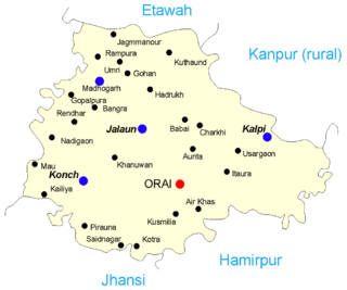
Jalaun is a city and a municipal board in Jalaun district in the Indian state of Uttar Pradesh.

Bithoor or Bithur is a town in Kanpur district, 23.4 kilometres (14.5 mi) by road north of the centre of Kanpur city, in Uttar Pradesh, India. Bithoor is situated on the right bank of the River Ganges, and is a centre of Hindu pilgrimage. Bithoor is also the centre for War of Independence of 1857 as Nana Sahib, a popular freedom fighter who was based there. The city is enlisted as a municipality of Kanpur metropolitan area.

Khalilabad is a city and a municipal board in Sant Kabir Nagar district in the Indian state of Uttar Pradesh. It is the district headquarters of Sant Kabir Nagar district.
Kannauj district is an administrative district of Uttar Pradesh state in northern India, along the river Ganges. The historic town of Kannauj, northwest of Kanpur, is the administrative center. The district was carved out of Farrukhabad district on 18 September 1997. The native dialect of this district is Kannauji.
Baghpat is a city in the Indian state of Uttar Pradesh. It is the administrative headquarters of Bagpat district, which was established in 1997. It is part of the National Capital Region, surrounding New Delhi.

Robertsganj also known as Sonbhadra City is a city and a municipal board in Sonbhadra district in the Indian state of Uttar Pradesh.
Aliganj is a town and a municipal board in Etah district in the state of Uttar Pradesh, India. Mahfooz ali khan former agriculture chairman of India and former member of parliament of India belonged to the city. Official name of Aliganj is Pargana Azamnagar. Aliganj is the 2nd largest residential area in Lucknow after Indira Nagar. Suneeta Gupta She is current Chairperson of Nagar Palika Parishad Aliganj
Chandpur is a town and a municipal board in Bijnor district in the Indian state of Uttar Pradesh, India.
Gursarai is a city and municipal board in the Jhansi district of the Indian state of Uttar Pradesh. Gursarai is situated in the Garautha Tehsil. An emerging city in Jhansi District With having an old and established market, it's a lifeline for the nearby village people who come and sell their farm produces.
Kandhla is a town, near Shamli City and municipal board in Shamli District in the Indian state of Uttar Pradesh.
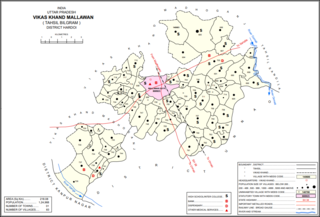
Mallawan, also spelled Mallanwan is a town and Nagar Palika Parishad in Hardoi district of Uttar Pradesh, India. It served as the original district headquarters from 1856 to 1858. It is located south of Bilgram, on the road to Unnao. Mallawan is a major centre of handloom weaving, with handloom cloth being a major export. As of 2011, the population of Mallawan is 36,915, in 6,086 households. It is included in the legislative assembly constituency of Bilgram-Mallanwan.
Manglaur Riyasat is a town with municipal board in Haridwar district in the Indian state of Uttarakhand. Pin code of Manglaur is 247656. Manglaur is located on national highway-58 (Delhi–Haridwar). It is 175 km away from Delhi and about 10 km from Roorkee.
Maudaha is a city and a Municipal Board in Hamirpur district, Uttar Pradesh, India.
Noorpur is a City and a Municipal Board in Bijnor District in the Indian State of Uttar Pradesh.
Patiyali is a town and a nagar panchayat in Kasganj District in the Indian state of Uttar Pradesh. It is located on the banks of River Ganga. It is the birthplace of Amir Khusrau. Patiyali is a constituency of District Kasganj. Member of Legislative Assembly from Patiyali is Nadira Sultan of Samajwadi Party. About hundred years ago the river Ganges flowed thorough Patiyali Quila.Patiyali Quila is a Quila of Raja Durpad from Mahabharat time. Nowadays it is 10 km away at Qadarganj. Dariyaganj lake of Patiyali covers an area of about 50 hectares. On the occasion of Kakode ka Mela thousands of people assemble at Kaderganj Ghat.
Sarsawa is a town at the border of Haryana and a municipal board in Saharanpur district in the Indian state of Uttar Pradesh.
Pali is a town and nagar panchayat in Sawayajpur tehsil of Hardoi district, Uttar Pradesh, India. It is on the right bank of the Garra river, 20 miles northwest of Hardoi, Pali historically served as the seat of a pargana and was a regional political headquarters under the Nawabs of Awadh. The town's name is possibly connected to the Pal dynasty that once ruled the nearby city of Kannauj. As of 2011, the population of Pali is 18,708 in 2,949 households.
Ghatampur is a town and a municipal board in Kanpur Nagar district in the state of Uttar Pradesh, India. It is just 45 minutes away from the main industrial and educational hub of the state Kanpur at a distance of 40 km.
Phaphund is a town and a nagar panchayat in Auraiya district in the Indian state of Uttar Pradesh.
1- List of Member of Parliament (MP) and Member of Legislative assembly (MLA) from Chhibramau, Chhibramau Pin code, Chhibramau registration number plate details at https://chibramau.com/
