Nagod or Nagaud is a town and a nagar panchayat in Satna district in the Indian state of Madhya Pradesh. It is located 17 miles (27 km) from the town of Satna. It is the administrative headquarters of Nagod Tehsil.It is believed that it was a small state owned by an oil-pressing people, known as 'Teli', who were exiled by the Pratiharas. Pratiharas originally came from Kannauj and belong to Agnikula Rajput.

Kannauj district is an administrative district of Uttar Pradesh state in northern India, along the river Ganges. The historic town of Kannauj, northwest of Kanpur, is the administrative center. The district was carved out of Farrukhabad district on 18 September 1997. The native dialect of this district is Kannauji.
Chhibramau is a "Nagar Palika Parishad" and a Subdivision(Tehsil) of Kannauj district in the northern state of Uttar Pradesh, India.
Ghansor is a small census town in Seoni district in the state of Madhya Pradesh. It serves the headquarters for Janpad panchayat Ghansor. It hosts a railway station which is in the South Eastern Central Railways zone connecting Jabalpur and Balaghat. It has a government community health centre and has a robust government education centre with a network of schools and colleges both private and public. It is well connected with bus services from Lakhnadon, Seoni, Jabalpur and Mandla. Examples of recorded temperature conditions are; the lowest temperature has been -4°C on a winter night at 3:00 am in 2018, and the highest temperature has been 52°C at 3.00 pm in summer, 2016.
Hirapur is a census town in Balaghat district in the Indian state of Madhya Pradesh.
Jatara is a town and a nagar palika parishad in Tikamgarh district in the Indian state of Madhya Pradesh.
Kamalganj is a town and a nagar panchayat in Farrukhabad district in the Indian state of Uttar Pradesh. The town is one of the key contributors to Potato production in the district. Kamalganj was named after Muslim religion promoter and social worker 'Kamal Baba'.
Kiraoli is a town and a nagar panchayat in Agra district in the Indian state of Uttar Pradesh.
Milak is a city and a municipal board in Rampur district in the Indian state of Uttar Pradesh.In field of legal education there is one Law college at village Guladia Bhatt Milak–Bilaspur road in name of Rampur College of Law Milak imparting legal education among students in whole Rampur district. Also there are several inter college and 3 degree colleges nearby: Rambahadur Degree college, Shri Hansraj Degree College, Shri Hira Mahavidyalaya.
Palashban is a census town in the Andal CD block in the Durgapur subdivision of the Paschim Bardhaman district in the Indian state of West Bengal.
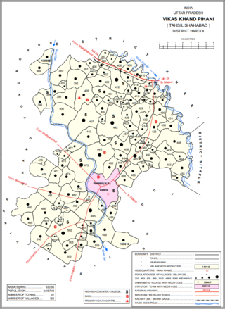
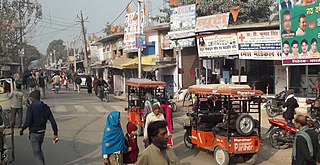
Pihani is a town and nagar palika parishad in Hardoi district of Uttar Pradesh, India. Historically, the city was a centre of sword production, leading to at least one British writer calling it "the Damascus of Oudh". Today, important industries in Pihani include jaggery and woven carpets. As of 2011, the town's population is 36,014, in 5,626 households. Pihani also serves as the headquarters of a community development block in Shahabad tehsil.
Polur is a scenic town, divisional headquarters and a market center in Tiruvannamalai district of Tamil Nadu in India. Located at the foothills of Javvadhi hills, a popular section of Eastern Ghats, Polur is often regarded as Gateway of Eastern ghats. Polur was once a eminent center of Tamil Jainism. The town is home to Dharani sugars, chemicals and fertiliser Pvt., Ltd, and number of agro based industries including coir industries. The famous Chittor - Cuddalore road passes through the town. The town is located 29 Kilometres north of city of Tiruvannamalai and 45 kilometres south of Vellore Metropolis.

Rasulabad is a town and a nagar panchayat in Kanpur Dehat district in the Indian state of Uttar Pradesh.
Sahajadpur is a census town in the Raghunathganj II CD block in the Jangipur subdivision of the Murshidabad district in the Indian state of West Bengal.
Saurikh is a nagar panchayat in Kannauj district in the Indian state of Uttar Pradesh. Its old name was Sau-Rishi.It is located near main industrial and educational hub of Dibiyapur which is around at a distance of 55 km from the town.
Tirwa is a town in Kannauj district in the Indian state of Uttar Pradesh.

Ujhani is an industry-based city and a municipal board in Badaun district in the Indian state of Uttar Pradesh.

Rajnagar is a town and nagar panchayat in Chhatarpur district in the Indian state of Madhya Pradesh, it is 6 km from Khajuraho, 5 km from Khajwa town and 35 km from district headquarters, Chhatarpur.
Sikanderpur is a town and a nagar panchayat in Kannauj district in the Indian state of Uttar Pradesh.

Akorhi Gola is a village and corresponding community development block in Rohtas district of Bihar, India. Located 6 km north of Dehri, Akorhi Gola is known for its blanket weaving industry. As of 2011, the village had a population of 3,810, in 601 households, while the total block population was 120,145.