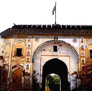
Firozabad is a city near Agra in Firozabad district in the state of Uttar Pradesh in India. It is the centre of India's glassmaking industry and is known for the quality of the bangles and also glasswares produced there.

Khetri Nagar is the town in Neem Ka Thana district of Rajasthan in India. It is a part of the Shekhawati region. Khetri consists of two towns, "Khetri Town" founded by Raja Khet Singhji Nirwan and "Khetri Nagar" which is about 10 km away from Khetri. Khetri Nagar, well known for its Copper Project, was built by and is under the control of Hindustan Copper Limited, a public sector undertaking under the Government of India. Khetri Nagar is also known as 'Copper'. There are many attached villages near Khetri Nagar like Manota Khurd, the people of this village was employed in mines. Khetri is full of heritage and diversity. People of various religions live with mutual cooperation and harmony here. Today this adorable part of India is the backward region due to lack of development. Khetri is the town and Tehsil in Jhunjhunu district of Rajasthan state in India. Total number of villages in this Tehsil is 106. Khetri Tehsil sex ratio is 914 females per 1000 of males. Average literacy rate of Khetri Tehsil in 2011 were 72.51%, in which male and female literacy were 85.58% and 58.39% respectively.

Siwan is a city and nagar parishad in the Indian state of Bihar. It is the administrative headquarters of Siwan district and one of the urban settlements out of three in the district. It is located close to Uttar Pradesh.
Jagraon is a city and a municipal council, a rural police district and a sub-division of the Ludhiana district in the Indian state of Punjab. Jagraon is more than three centuries old. Jagraon is at almost the geographical center of the state, 16 kilometres (9.9 mi) from the Satluj River. It is 37 km (23 mi) from its district headquarters Ludhiana, 29 km (18 mi) from Moga, 31 km (19 mi) from Nakodar and 54 miles from Barnala.
Afzalgarh is a city and a municipal board in Bijnor district in the Indian state of Uttar Pradesh. It is located at the border with the state of Uttarakhand.
Begumganj is a town and a municipality in Raisen district in the state of Madhya Pradesh, India. and is located on the Bhopal - Sagar National Highway 120 km away from Bhopal. It is one of the five divisions of the Raisen district.

Bhitarwar is a city and a Municipality in Gwalior district in the state of Madhya Pradesh, India. The town is surrounded by a river called Parbati.
Chichli is a census town in Narsimhapur district in the state of Madhya Pradesh, India.

Gajraula is a city and municipal board in Amroha district in the state of Uttar Pradesh, India. Gajraula is also the headquarters of Gajraula block. It is located on NH 9, a four-lane highway connecting Uttarakhand and cities such as Bareilly and Lucknow via Delhi. It is a significant industrial hub in Uttar Pradesh and home to a number of multinational corporations, including Jubliant Life Sciences, RACL Geartech, and Israeli Pharma Teva API, as well as several engineering colleges. Moradabad, Meerut, Bulandsahar, Budaun, Hapur, and Delhi NCR are among the larger nearby cities.
Kasganj is a city and the district headquarters of Kasganj district in the Indian state of Uttar Pradesh. The district was formed by grouping three Tehsils at 17 April 2008. Meena Maheshwari,she is current mayor of Nagar Palika Parishad Kasganj BJP
Khaniyadhana is a tehsil and a Nagar Palika in Shivpuri district in the Indian state of Madhya Pradesh. It is known for its eight Jain temples.
Marehra, is a city and a municipal board in Etah district in the state of Uttar Pradesh, India. Marehra is also famous for the temple of Lord Hanuman, where the statue of Hanuman is the highest in the Etah district. Marehra was once called Swaroopganj. Books written about the history of Etah mention that the village of Swaroopganj was destroyed by the forces of Allauddin Khilji.
Okni is a neighbourhood of Hazaribagh town in Hazaribagh district in the Indian state of Jharkhand.

Sadabad is a town and a nagar panchayat in Hathras district in the Indian state of Uttar Pradesh.
Salumbar is a city in Salumbar district, in the Indian state of Rajasthan. Salumbar is a part of "Mewar" dynasty. Salumbar is also known as "Hadirani nagri" which has history of queen Hadirani who sacrificed her life to motivate her husband to go to a battle.
Sidhpura is a town and a nagar panchayat in Kasganj district in the Indian state of Uttar Pradesh. It is situated 23 km from Etah in East North-East direction and 31.7 km away from Kasganj in East.

Srinivaspur is a town located in the Kolar district of Karnataka state, India. The latitude 13.33 and longitude 78.22 are the geocoordinate of the Srinivaspur. Bengaluru is the nearby state capital for Srinivaspur town. It is located around 106 km away from Bengaluru and 80 km from BIAL. The other surrounding state capitals are Chennai 225.9 km., Pondicherry 233.2 km., Hyderabad 453.4 km.,
Thakurdwara is a town in Moradabad district in the indian state of Uttar Pradesh.
Thazhakudy is a panchayat town in Kanniyakumari district in the Indian state of Tamil Nadu. This village is situated between 2 rivers "Puthanaar" and "Palaiyaar". There are also few temples in and around Thazhakudy. Avvaiyar Amman temple is one among them which is 2 km towards East from Thazhakudy.
Tuahzawl is located near Rawpuichhip(3 km) and near to state capital Aizawl which is 40 km away, it is located near Lengpui Airport which is about 20 km and it is located in Mamit district in the Indian state of Mizoram. Pin Code - 796410


