Related Research Articles
Vindhyachal is a city in Mirzapur district of the Indian state of Uttar Pradesh. The city is a Hindu pilgrimage site having the temple of Vindhyavasini, who according to Markandeya Purana, had incarnated to kill the demon Mahishasura. A detailed description has been given in the 'Durga Saptashati' chapter of the Markandeya Purana. The river Ganga flows through this city. The Indian Standard Time (IST) line passes through the Vindhyachal railway station.

Sant Ravidas Nagar District is a district of Uttar Pradesh state in northern India. The city of Bhadohi is the district headquarters. Bhadohi is one of largest centres of Carpet Industries in India and is worldwide known as 'Carpet City of India'. Carpets of Bhadohi have 'Geographical Indication' tag attached to it. Bhadohi has huge geographical significance and position attached to it due to its location between two culturally important and rich heritage cities of Prayagraj and Varanasi.
Kendrapara is a Town and a municipality in the Kendrapara district of the Indian state of Odisha. It is the headquarters of Kendrapara district.
Thiruverkadu is a Western suburb of Chennai, Tamil Nadu. It comes under Thiruvallur district administration. It is famous for its Devi Karumariamman Temple. There is also Vedapureeswarar Temple in Thiruverkadu, where Lord Shiva and Goddess Parvathi are seen in their wedding pose inside the sanctum sanctorum. As of 2011, the town had a population of 62,289. It is a town with rich cultural heritage and also a fast-growing areas in the city.

Chunchanakatte Falls is a waterfall on the Kaveri River, near the village of Chunchanakatte in saligrama taluk of Mysore district, Karnataka, India. Water cascades from a height of about 20 meters. It is in the Western Ghats. Here the river falls in two small cascades before joining again to flow as one.

Chikkodi is a taluka and Town Municipal Council in the Belagavi district of Karnataka, India. It is a Subdivision of the district. Chikodi, Athani, Hukkeri, Raybag, Nipani and Kagwad are the taluks that come under Chikodi Subdivision. It is 75 kilometers from the city of Belgaum, 65 kilometers from Kolhapur, 51 kilometers from Miraj, 160 kilometers from Hubballi, and 570 kilometers from the capital of Karnataka state, Bengaluru. Chikodi has many district level offices but it is not designated as a district by the Government of Karnataka. It is one of the major cities that lies in the border between Karnataka and Maharashtra states.official language is Kannada.
Khusrupur is a town and a notified area in Patna district of Bihar state, India. It is situated at the bank of river the Ganges. It is located on NH-30, 34 kilometers east of Patna. By rail, it is 31 kilometers east of Patna.
Kotdwar is a city, municipal corporation in Pauri Garhwal district of Uttarakhand, India. It is just 101 km from Pauri, the district headquarter. It is the eighth-largest city in Uttarakhand. Its old name was "Kootdwar", which means the gateway of the high hill koot as Chitra koot, since it is located on the bank of river Khoh. It is situated in the southwestern part of the state and is one of the main entrance points in the state of Uttarakhand.
Mahuva is a town and taluka of Bhavnagar District, in the state of Gujarat, India. Located on the coast of the Arabian Sea, Mahuva is known for its mild weather and green, lush surroundings, including many coconut tree plantations. The town is a part of the Saurashtra region and is known as the Kashmir of Saurashtra. Mahuva is also known for wooden toys, raw onions, groundnuts, and a local variety of mango called the Jamadar. The region is home to a thriving agribusiness industry, particularly enterprises that dehydrate vegetables such as garlic and onions for use in processed foods.
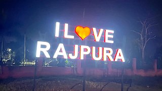
Rajpura is a city in Patiala district in the Indian state of Punjab, India, situated along the border of the Indian state of Haryana. It is located 26 KM Patiala city, towards East from District Head Quarter. It is Tehsil Head Quarter. Rajpura is the largest tehsil of the district.
Umarkhed is a Municipal council in Yavatmal district of Indian State of Maharashtra. Audumber Nagari is the name given to Umarkhed city in Maharashtra, India, before the Mughal invasion.
Verkilambi is an interior rural area the district of Kanyakumari at the state of Tamil Nadu. This is a grade – I Town panchayat spread in a total area of 15.7 Sq. km and consists of 18 wards, represented by 18 councilors. The Executive officer is the administrative head and the elected Chairman is the political head of this Town Panchayat. This was constituted as Kumarankudy Village, Pathmanapapuram MLA Constituency, Nagercoil MP Constituency. The town is located at a distance of 5 km from Ponmanai Town Panchayat on the East, 5 km from Thiruvattar Town Panchayat on the west. 3 km from Kothanalloor Town Panchayat on the South. This town is located along the Kanyakumari, Thiruvananthapuram, National High way and Colachel – Kulasekaram state high way Road through this TP. This TP Constitutes its village component to talking an area of 3.25 Sq. km up graded as town Panchayat

Parner taluka is a taluka in Ahmednagar district in the state of Maharashtra in western India.
Lingda is a village in Anand district in the Indian state of Gujarat. It is located in Umreth Taluka on the Nadiad-Dakor road. The name was derived from the temple of Lord Shiva, named લીંગડા.
Jayapur is a village in Varanasi tehsil, Varanasi district of Uttar Pradesh, India. It is about 28 km from the Varanasi cantt railway station and about 7 km from the Rajatalab railway station in the Sevapuri assembly segment and Aaraji Line Block. This place is situated at the border of the Varanasi District and Mirzapur District. Jayapur is surrounded by Arajiline Tehsil towards the east and Shikhar Tehsil towards the south.

Bhidauni is a village and Gram panchayat of two villages, Kewat Nagla and Bhidauni officially known as Bhidauni Bangar located between the Yamuna river and Yamuna Expressway in the Mat Tehsil of Mathura district, Uttar Pradesh, India. It is situated approximately 45 kilometers away from Mathura City, on the Raya Road connecting via Mant to Naujheel Road.

Gupteshwar Mahadev is a popular temple of the lord Shiva in the Udaipur city in the state of Rajasthan, India.
Sukhanand Dham or Sukhanand ji is located at a distance of about 10 km (6.2 mi) from the city of Jawad, which is more of an ancient rock-cave that is located on the border of the Rajasthan State. This ashram is said to be built by the son of Vedavyasa, known by the name of Suka, Sukadev, Sri Suka and Brahmarata. This ashram also consists of a temple dedicated to Lord Shiva and it is wholly surrounded by the mountains and a waterfall and Sukhanand Sagar Dam nearby.

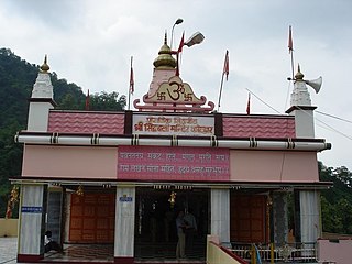
Vindhyachal Temple, also known as Maa Vindhyavasini Temple and Vindhyachal Dham, is a Hindu temple dedicated to the mother goddess Vindhyavasini, situated on the bank of river Ganga at Vindhyachal in Mirzapur district, Uttar Pradesh. It is one of the Shakti Pitha temples in India.
References
- ↑ "अमेठी के रघईपुर में दो पक्षों भिड़े, एक की मौत, दस घायल, गांव में अतिरिक्त पुलिस बल तैनात". www.lokmatnews.in. Retrieved 19 July 2021.
| | This Mirzapur district location article is a stub. You can help Wikipedia by expanding it. |