Sirsi Baghel | |
|---|---|
Village | |
| Country | |
| State | Uttar Pradesh |
| Government | |
| • Body | Gram panchayat |
| Languages | |
| • Official | Hindi, Urdu, Awadhi, Agariya |
| PIN | 231307 |
| Website | up |
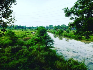
Sirsi Baghel is a village in Mirzapur, Uttar Pradesh, India. [1] [2]
Sirsi Baghel | |
|---|---|
Village | |
| Country | |
| State | Uttar Pradesh |
| Government | |
| • Body | Gram panchayat |
| Languages | |
| • Official | Hindi, Urdu, Awadhi, Agariya |
| PIN | 231307 |
| Website | up |
Sirsi Baghel is a village in Mirzapur, Uttar Pradesh, India. [1] [2]
In 2011 there were 1,837 people living in Sirsi Baghel. [3]

Ayodhya district is an administrative district of the Indian state of Uttar Pradesh. The city of Ayodhya is its administrative headquarters. The district occupies an area of 2,522 square kilometres (974 sq mi), and had a population of 2,470,996 in the 2011 census. Ayodhya district shares its borders with 6 districts of Uttar Pradesh. It is bordered by Gonda and Basti districts on the northern side, Amethi and Sultanpur districts on the south, and Ambedkar Nagar and Barabanki districts share the border on the east and west.

Mau district is one of the districts of Uttar Pradesh state of India, and Mau town is the district headquarters which is also one of the few remaining areas of handloom saree production in eastern Uttar Pradesh, specializing in Sadiya silk sarees. Mau was carved out as a separate district from Azamgarh on 19 November 1988. It is situated in the south-eastern part of the state with headquarters in Maunath Bhanjan. The district is surrounded by Ghazipur district on the south, Ballia district in the east, Azamgarh district in the west, and by Gorakhpur and Deoria districts on the north; says, Pallavi mishra.

Hamirpur district is one of the 75 districts of Uttar Pradesh state of India and Hamirpur town is the district headquarters. Hamirpur district is a part of Chitrakoot Division. The district occupies an area of 4,121.9 km². The district has a population of 1,104,285. As of 2011 it is the third least populous district of Uttar Pradesh, after Mahoba and Chitrakoot. Two major rivers Yamuna and Betwa meet here. On the banks of river Betwa lies the "Coarse sand" which is exported to many parts in U.P.

Ayodhya division is an administrative geographical unit of Uttar Pradesh state in India. Ayodhya is the administrative headquarters of the division. The government of Uttar Pradesh approved the renaming of the Faizabad division to Ayodhya division in November 2018.

Bhadohi District is a district of Uttar Pradesh state in northern India. The city of Bhadohi is the district headquarters. Bhadohi is one of largest centres of Carpet Industries in India and is worldwide known as 'Carpet City of India'. Carpets of Bhadohi have 'Geographical Indication' tag attached to it. Bhadohi has huge geographical significance and position attached to it due to its location between two culturally important and rich heritage cities of Prayagraj and Varanasi.

Mirzapur district is one of the 75 districts in the Indian state of Uttar Pradesh. The district is bounded on the north by Bhadohi and Varanasi districts, on the east by Chandauli district, on the south by Sonbhadra district and on the northwest by Prayagraj. The district occupies an area of 4521 km2. Mirzapur city is the district headquarters. Mirzapur district is a part of Mirzapur division. This district is known for the Vindhyavasini temple in Vindhyachal and several tourist attractions like water falls like Rajdari & Devdari and dams. It consist of several Ghats where historical sculptures are still present. During the Ganges festival these Ghats are decorated with lights and diyas.
Nyotini is a town and nagar panchayat in Hasanganj tehsil of Unnao district, Uttar Pradesh, India. Located 3 km southeast of Hasanganj on the right bank of the Sai river, Nyotini was historically one of the main centres of Muslim settlement in the district and it has several mosques and shrines. As of 2011, its population is 7,577, in 1,212 households.
Sirsi Sadat is a town and a Nagar Panchayat in the Sambhal district of the Indian state of Uttar Pradesh.

Satna District is a district of Madhya Pradesh state in central India. The city of Satna is the district headquarters. The district has an area of 7,502 km², and a population of 22,28,935(2011 census), 20.63% of which is urban. The district has a population density of 249 persons per km².
Ahirauli Baghel is an Indian village located in Uttar Pradesh, India. Ahirauli Baghel comes under Bankata Block of Deoria district. It belongs to Gorakhpur division. It is located 47 KM towards East from district headquarter Deoria. It distance is 374 KM from State capital Lucknow. Bhojpuri and Hindi is the primary language spoken in this village.
Bhadehari is a village in Kerakat nagar panchayat, Jaunpur, Uttar Pradesh, India.
Gahlai is a village in Jaunpur, Uttar Pradesh, India. It is home of the famous temple Durgadevi which is situated on bank of River Basuhi. Every Tuesday thousands of people come there for prayer and to enjoy the fair.

Karhal Assembly constituency is one of the 403 constituencies of the Uttar Pradesh Legislative Assembly, India. It is a part of the Mainpuri district and one of the five assembly constituencies in the Mainpuri Lok Sabha constituency. First election in this assembly constituency was held in 1957 after the "DPACO (1956)" was passed in 1956. After the "Delimitation of Parliamentary and Assembly Constituencies Order" was passed in 2008, the constituency was assigned identification number 110.

Sarasara is a village in Badlapur, Jaunpur district, Uttar Pradesh, India.
Khushalpur is a town in Hathras district of Uttar Pradesh State, India. It is located NH91 Khushalpur Road |01|km from sub district headquarter|42|km and 41 kilometres (25 mi) from district headquarter. The City is administrated by Chairman an elected representative of the City.

Bichhiya is a village and corresponding community development block in Unnao district of Uttar Pradesh, India. Located about 16 km southeast of Unnao on the main road to Purwa, it also serves as the seat of a nyaya panchayat and has an Ayurvedic dispensary, a veterinary hospital, an artificial insemination centre, and a family planning centre. The main crops are wheat, gram, barley, juwar, and paddy, and irrigation is largely provided by canal. As of 2011, the village's population is 2,347, in 482 households.

Sumerpur is a hamlet of the village Chhanchhi Rai Khera, in Purwa tehsil of Unnao district, Uttar Pradesh, India. Located 26km south of Purwa and 50km southeast of Unnao, Sumerpur serves as the headquarters of a community development block as well as a nyaya panchayat. Sumerpur block was first established on 2 October 1955 in order to oversee implementation of India's Five-Year Plans at a local and rural level. As of 2011, the block comprises 148 villages and has a total population of 151,933 people in 28,469 households.

Rampur Baghel is a village in Rahi block of Rae Bareli district, Uttar Pradesh, India. It is located 11 km from Rae Bareli, the district headquarters. As of 2011, it has a population of 670 people, in 106 households. It has one primary school and no healthcare facilities.

Kasimpur Baghel is a village in Rahi block of Rae Bareli district, Uttar Pradesh, India. It is located 10 km from Rae Bareli, the district headquarters. As of 2011, it has a population of 410 people, in 74 households. It has no schools and no healthcare facilities.

Sirsi is a village in Dih block of Rae Bareli district, Uttar Pradesh, India. It is located 25 km from Raebareli, the district headquarters. As of 2011, it has a population of 1,395 people, in 261 households. It has one primary school and no healthcare facilities, and it hosts both a permanent market and a weekly haat. It belongs to the nyaya panchayat of Birnawan.
25°06′N82°34′E / 25.100°N 82.567°E