
Nokha is a nagar panchayat town and corresponding community development block in Rohtas district in the Indian state of Bihar. As of 2011, the population of the town of Nokha was 27,302 in 4,381 households. The rural population of Nokha block was 146,025, thus bringing the total block population 173,327. The economic situation of this region is mainly dependent on parboiled rice processed by number of rice mills in this area.
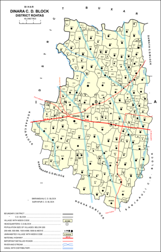
Dinara is a regional market in Rohtas district, Bihar, India, near the National Highway 30. The birthplace of the famous poet Dariya Saheb is just 5 km from Dinara.
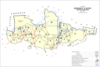
Barhara, also spelled Badahar, Barahara, or Barahra, is a village and corresponding community development block in Bhojpur District of Bihar, India. It is situated on the bank of the river Ganges. By the time of July–August most of the villages under this block are affected by deluge. As of 2011, its population was 6,889, in 927 households, while the total block population was 240,636, in 35,185 households.

Chenāri or Chanāri is a census town and corresponding community development block in Rohtas district of Bihar, India. As of 2011, the town of Chenari had a population of 6,569, while Chenari block had a population of 131,528. Major commodities produced in the town of Chenari are chironji, rice, and pulses. The census town of Bhardua is administratively counted as part of Chenari block.

Rajpur is a village and corresponding community development block in Rohtas district of Bihar, India. As of 2011, the village of Rajpur had a population of 11,780, in 1,778 households, while Rajpur block had a population of 75,213.

Nauhatta is a village and corresponding community development block in Rohtas district of Bihar, India. As of 2011, the village of Nauhatta had a population of 5,103, in 909 households, while Nauhatta block had a population of 94,065, in 16,387 households. The nearest city is Dehri.

Kargahar is a village and corresponding community development block in Rohtas district of Bihar, India. As of 2011, the population of Kargahar was 10,170, in 1,464 households, while the population of Kargahar block was 225,082, in 31,528 households. The nearest city is Sasaram, the district headquarters.
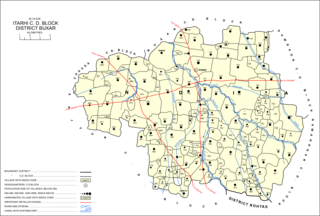
Itarhi is a village and corresponding community development block in Buxar district of Bihar, India. According to the 2011 Census of India, its population is 10,275, in 1,711 households, while the total block population is 170,629, in 25,557 households.
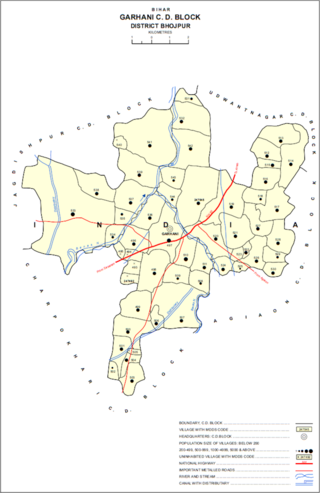
Garhani is a village and corresponding community development block in Bhojpur district of Bihar, India. As of 2011, its population was 5,597, in 959 households. The total block population was 103,262, in 16,427 households.

Udwantnagar is a village and corresponding community development block in Bhojpur district of Bihar, India. As of 2011, its population was 9,000, in 1,496 households. The total block population was 157,809, in 24,336 households.

Charpokhari is a village and corresponding community development block in Bhojpur district of Bihar, India. As of 2011, its population was 1,874, in 314 households. The total block population was 101,363, in 15,961 households.
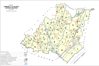
Tarari is a village and corresponding community development block in Bhojpur district of Bihar, India. As of 2011, its population was 3,586, in 393 households. The total block population was 182,631, in 28,316 households.

Agiaon is a village and corresponding community development block in Bhojpur district of Bihar, India. As of 2011, its population was 4,801, in 835 households. The total block population was 148,373, in 23,117 households.

Sandesh is a village and corresponding community development block in Bhojpur district of Bihar, India. As of 2011, its population was 6,874, in 1,037 households. The total block population was 109,712, in 17,011 households.
Chainpuris a Town and corresponding community development block in Kaimur district of Bihar, India. It is located 11km west of Bhabua, the district headquarters of kaimur district .As of 2011, the village population was 11,306, in 1,653 households. The block population was 187,692, in 30,189 households. The main village Chainpur was also before known as Malikpur on the name of zamindar Malik Khan one of the descendants from the family of Bhabua. Chainpur was established in early 1600s. Chainpur was the capital of Chainpur Estate.
Chand is a village and corresponding community development block in Kaimur district, Bihar, India. As of 2011, its population was 4,432, in 700 households. The total block population was 133,682 in 20,413 households.
Nuaon, also spelled Noawan or Noan, is a village and corresponding community development block in Kaimur district of Bihar, India. As of 2011, its population was 5,292, in 798 households, while the overall block population was 106,530, in 15,263 households.
Ramgarh is a census town and corresponding community development block in Kaimur district of Bihar, India. As of 2011, its population was 8,690, in 1,345 households. It was first upgraded to census town status for the 2011 census. The total population of the rural areas of Ramgarh block was 123,973, in 18,375 households. The overall population of the subdistrict was 132,663.
Bhagwanpur is a village and corresponding community development block in Kaimur district of Bihar, India. As of 2011, its population was 6,213, in 1,081 households, while the total block population was 91,113, in 15,145 households.
Rampur is a village and community development block in Kaimur district of Bihar, India. As of 2011, it had a population of 575, in 94 households. The total block population was 88,876, in 14,110 households.

