
Meghalaya is a state in northeast India. Meghalaya was formed on 21 January 1972 by carving out two districts from the state of Assam: (a) the United Khasi Hills and Jaintia Hills and (b) the Garo Hills. The estimated population of Meghalaya in 2014 was 3,211,474. Meghalaya covers an area of approximately 22,429 square kilometres, with a length-to-breadth ratio of about 3:1.

Shillong is a hill station and the capital of Meghalaya, a state in northeastern India. It is the headquarters of the East Khasi Hills district. Shillong is the 330th most populous city in India with a population of 143,229 according to the 2011 census. It is said that the rolling hills around the town reminded the British of Scotland. Hence, they would also refer to it as the "Scotland of the East".

The Khasi people are an ethnic group of Meghalaya in north-eastern India with a significant population in the bordering state of Assam, and in certain parts of Bangladesh. Khasi people form the majority of the population of the eastern part of Meghalaya, that is Khasi Hills, constituting 78.3% of the region's population, and is the state's largest community, with around 48% of the population of Meghalaya. They are among the few Austroasiatic-speaking peoples in South Asia. The Khasi tribe holds the distinction of being one of the few remaining tribes that have a matrilineal society. Under the Constitution of India, the Khasis have been granted the status of Scheduled Tribe.

The Khasi Hills are a low mountain formation on the Shillong Plateau in the Meghalaya state of India. The Khasi Hills are part of the Garo-Khasi-Jaintia range and connect with the Purvanchal Range and larger Patkai Range further east. The Khasi Hills, and the whole Garo-Khasi-Jaintia range, are in the Meghalaya subtropical forests ecoregion.

Jowai is the headquarters of the West Jaintia Hills district of the state of Meghalaya, India, and is home to the Pnar, a sub-tribe of the Khasi people. It is located on a plateau surrounded on three sides by the Myntdu river bordering Bangladesh to the south. Due to its high altitude of 1365 m above sea level, Jowai experiences warm summers with cool to chilly winters.
Shri Hoping Stone Lyngdoh was an Indian politician who was the president of the Hill State People's Democratic Party (HSPDP), one of three official political parties of the state of Meghalaya in India. He was the son of late Hajur Shon; was born at Nonglait Village, West Khasi Hills District on March 15, 1929; he studied at St. Anthony's College, Shillong.

The Jaintia Kingdom was a kingdom in present-day some parts of Bangladesh's Sylhet Division, India's Meghalaya state and Nagaon, Morigoan district of Assam. It was partitioned into three in 630 AD by Raja Guhak for his three sons, into the Jaintia Kingdom, Gour Kingdom and Laur Kingdom. It was annexed by the British East India Company in 1835. All the Pnar Rajahs of the Jaintiapur Kingdom are from the Syiem Sutnga clan, a Pnar clan of the Khasi tribe which claims descent from Ka Li Dohkha, a divine nymph.
The Pnar, also known as Jaiñtia, are a sub-tribal group of the Khasi people in Meghalaya, India. The Pnar people are matrilineal. They speak the Pnar Language, which belongs to the Austro-Asiatic language family and is very similar to the Khasi language. The Pnar people are natives of West Jaintia Hills and East Jaintia Hills District of Meghalaya, India. They call themselves as "Ki Khun Hynñiew Trep". Their main festivals are Behdeinkhlam, Chad Sukra, Chad Pastieh and Laho Dance.

Khasi Hills Autonomous District Council (KHADC) is an autonomous district council in the state of Meghalaya in India. It covers West Khasi Hills district, Eastern West Khasi Hills district, East Khasi Hills district and Ri Bhoi district. It is one of the three autonomous district councils within Meghalaya, and one of twenty-five autonomous regions of India. Between its foundation on 27 June 1952 and 14 June 1973 it was known as the United Khasi-Jaintia Hills District Council. The total area of the Khasi Hills Autonomous District Council is 11,718 km2 having a population of 1,578,375 as of 2011.

Jaintia Hills Autonomous District Council (JHADC) is an autonomous district council in the state of Meghalaya in India. It is one of the three autonomous district councils within Meghalaya, and one of twenty-five autonomous regions of India. Present Jaintia hills was a part of historical Jaintia Kingdom. It was formed as the Jowai Autonomous District Council on 23 November 1964 from the Jowai Subdivision of the United Khasi-Jaintia Hills District – adopting its current name on 14 June 1973.
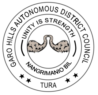
Garo Hills Autonomous District Council (GHADC) is an autonomous district council in the state of Meghalaya in India. It is seated at Tura and covers East Garo Hills district, West Garo Hills district, South Garo Hills district, North Garo Hills district and South West Garo Hills district; is one of the three Autonomous District Councils within Meghalaya, and one of twenty-five autonomous regions of India. The total area of the Garo Hills Autonomous District Council is 10,102 sq km having a population of 1,394,362 as of 2011.

The Hynniewtrep National Liberation Council is a militant organization operating in Meghalaya, India. It claims to represent the Khasi-Jaintia tribal people, and its aim is to free Meghalaya from the alleged domination of outsiders from the Indian mainland. It was proscribed in India on 16 November 2000, but the ban was later lifted, before banning it again in 2019.
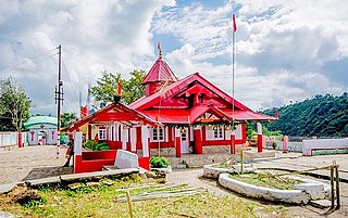
Nartiang Durga Temple is a 600-year-old temple located in the West Jaintia Hills district of Meghalaya in northeastern India. It is one of the 51 Shakti Peethas and is one of the holiest sites for devotees of the Shaktism sect of Hinduism. The Hindus in the Jaintia Hills of Meghalaya believes that this temple is the permanent abode of Goddess Durga. The temple draws a large number of pilgrims from all over the country on occasion of Durga Puja. The Shakti of Nartiang Devi shrine is worshipped as Jayanti and the Bhairava as Kamadishwar.
Williamson Ampang Sangma, was a Garo leader, and the first Chief Minister of Meghalaya. He was also the first ever Governor of Mizoram among the Garos in 1989.
Evangelization of Meghalaya began in the 19th century during the British era. In the 1830s, American Baptist Foreign Missionary Society had become active in Northeast to evangelize indigenous tribes to Christianity. Later, they were offered to expand and reach into Sohra Meghalaya, but they lacked the resources to do so and declined. Welsh Presbyterian Mission took the offer and they began work at Sohra mission field. By the early 1900s, other Protestant denominations of Christianity were active in Meghalaya. The outbreak of World Wars forced the preachers to return home to Europe and America. It is during this period that Catholicism took root in Meghalaya and neighbouring region. Currently, Catholics, Presbyterians and Baptists are three most common Christian denominations found in Meghalaya.
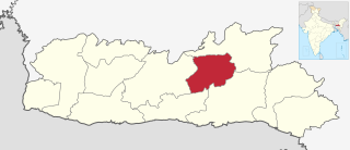
West Jaintia Hills is an administrative District in the state of Meghalaya in India. The united district was created on 22 February 1972 and occupied an area of 3819 km2. It had a population of 272,185. The district is part of the Meghalaya subtropical forests eco-region. With the bifurcation of the erstwhile Jaintia Hills District into East and West Jaintia Hills Districts, West Jaintia Hills District came into existence on 31 July 2012 with its headquarters at Jowai. Jowai is the host of all the heads of important governmental offices and establishments, educational institutions, hospitals, banking institutions, etc.
The hill tribes of Northeast India are hill people, mostly classified as Scheduled Tribes (STs), who live in the Northeast India region. This region has the largest proportion of scheduled tribes in the country.
Hinduism is a minority religion in the Meghalaya state of India constituting 12% of the state's population. The Nartiang Durga Temple in Meghalaya is one of the 51 Shakti peethas on Earth and is considered by Hindus of Meghalaya as the permanent abode of Goddess Durga. Hinduism is a popular religion practice by Rabhas, Hajongs, Kochs, Rajbongshis, Mikirs, Bengalis, Nepalis, Biharis etc.
Eastern West Khasi Hills is a district in the Indian state of Meghalaya, located approximately 25 kilometres (16 mi) west of the state capital of Shillong. It was created in 2021, after bifurcation of existing West Khasi Hills district. The territories which make up the district recorded a total population of 131,451 in the 2011 census. The district headquarters is the town of Mairang.
