Roof of the World

Last updated
Physical map of Central Asia from the Caucasus in the northwest, to Mongolia in the northeast. Central Asia Physical.jpg
Physical map of Central Asia from the Caucasus in the northwest, to Mongolia in the northeast.

The Roof of the World or Top of the World is a metaphoric epithet or phrase used to describe the highest region in the world, also known as High Asia. The term usually refers to the mountainous interior of Asia, including the Pamirs, the Himalayas, the Tibetan Plateau, the Hindu Kush, the Tian Shan, and the Altai Mountains.

Contents

Attested usage

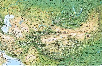
The British explorer John Wood, writing in 1838, described Bam-i-Duniah (Roof of the World) as a "native expression" (presumably Wakhi), [1] and it was generally used for the Pamirs in Victorian times: In 1876, another British traveler, Sir Thomas Edward Gordon, employed it as the title of a book [2] and wrote in Chapter IX:

"We were now about to cross the famous 'Bam-i-Dunya', 'The Roof of the World' under which name the elevated region of the hitherto comparatively unknown Pamir tracts had long appeared in our maps.[...] Wood, in 1838, was the first European traveler of modern times to visit the Great Pamir,". [3]

Older encyclopedias also used "Roof of the World" to describe the Pamirs:

With the awakening of public interest in Tibet, the Pamirs, "since 1875 ... probably the best explored region in High Asia", [4] went out of the limelight and the description "Roof of the World" has been increasingly applied to Tibet [9] [10] and the Tibetan plateau, and occasionally, especially in French ("Toit du monde"), even to Mt. Everest, [11] but the traditional use is still alive. [12]

Where the world's tallest mountain ranges meet High Asia Mountain Ranges.jpg
Where the world's tallest mountain ranges meet
Panorama of the Pamirs, the Original Roof of the World Pamir panorama.jpg
Panorama of the Pamirs, the Original Roof of the World

See also

Related Research Articles

<span class="mw-page-title-main">Geography of China</span>

China has great physical diversity. The eastern plains and southern coasts of the country consist of fertile lowlands and foothills. They are the location of most of China's agricultural output and human population. The southern areas of the country consist of hilly and mountainous terrain. The west and north of the country are dominated by sunken basins, rolling plateaus, and towering massifs. It contains part of the highest tableland on earth, the Tibetan Plateau, and has much lower agricultural potential and population.

<span class="mw-page-title-main">Himalayas</span> Mountain range in Asia, separating Indo-Gangetic plain from Tibetan Plateau

The Himalayas, or Himalaya is a mountain range in Asia, separating the plains of the Indian subcontinent from the Tibetan Plateau. The range has some of the Earth's highest peaks, including the highest, Mount Everest; more than 100 peaks exceeding elevations of 7,200 m (23,600 ft) above sea level lie in the Himalayas.

<span class="mw-page-title-main">Karakoram</span> Major mountain range spanning the borders between India Pakistan and China

The Karakoram is a mountain range in the Kashmir region spanning the borders of Pakistan, China. Most of the Karakoram mountain range falls under the jurisdiction of Gilgit-Baltistan, which is administered by Pakistan. Its highest peak, K2, is located in Gilgit-Baltistan. It begins in the Wakhan Corridor (Afghanistan) in the west, encompasses the majority of Gilgit-Baltistan, and extends into Ladakh and Aksai Chin.

<span class="mw-page-title-main">Geography of Tibet</span> Geographical features of Tibet

The geography of Tibet consists of the high mountains, lakes and rivers lying between Central, East and South Asia. Traditionally, Western sources have regarded Tibet as being in Central Asia, though today's maps show a trend toward considering all of modern China, including Tibet, to be part of East Asia. Tibet is often called "the roof of the world," comprising tablelands averaging over 4,950 metres above the sea with peaks at 6,000 to 7,500 m, including Mount Everest, on the border with Nepal.

<span class="mw-page-title-main">Pamir Mountains</span> Mountain range in Central Asia

The Pamir Mountains are a range of mountains between Central Asia and Pakistan. They are located at a junction with other notable mountains, namely the Tian Shan, Karakoram, Kunlun, Hindu Kush and the Himalaya mountain ranges. They are among the world's highest mountains.

<span class="mw-page-title-main">Tibetan Plateau</span> Plateau in Central, South and East Asia

The Tibetan Plateau, also known as Qinghai–Tibet Plateau and Qing–Zang Plateau, is a vast elevated plateau located at the intersection of Central, South, and East Asia covering most of the Tibet Autonomous Region, most of Qinghai, western half of Sichuan, Southern Gansu provinces in Western China, southern Xinjiang, Bhutan, the Indian regions of Ladakh and Lahaul and Spiti as well as Gilgit-Baltistan in Pakistan, northwestern Nepal, eastern Tajikistan and southern Kyrgyzstan. It stretches approximately 1,000 kilometres (620 mi) north to south and 2,500 kilometres (1,600 mi) east to west. It is the world's highest and largest plateau above sea level, with an area of 2,500,000 square kilometres (970,000 sq mi). With an average elevation exceeding 4,500 metres (14,800 ft) and being surrounded by imposing mountain ranges that harbor the world's two highest summits, Mount Everest and K2, the Tibetan Plateau is often referred to as "the Roof of the World".

<span class="mw-page-title-main">Baltistan</span> Region of Pakistani-administered Kashmir

Baltistan also known as Baltiyul or Little Tibet, is a mountainous region in the Pakistani-administered territory of Gilgit-Baltistan and constitutes an northern portion of the larger Kashmir region that has been the subject of a dispute between India and Pakistan since 1947. It is located near the Karakoram and borders Gilgit to the west, China's Xinjiang to the north, Indian-administered Ladakh to the southeast, and the Indian-administered Kashmir Valley to the southwest. The average altitude of the region is over 3,350 metres (10,990 ft). Baltistan is largely administered under the Baltistan Division.

<span class="mw-page-title-main">Wakhan</span> Mountainous area of northeastern Afghanistan

Wakhan, or "the Wakhan", is a rugged, mountainous part of the Pamir, Hindu Kush and Karakoram regions of Afghanistan. Wakhan District is a district in Badakshan Province.

<span class="mw-page-title-main">Northern Pakistan</span> Geographical region in Pakistan

Northern Pakistan is a tourism region in northern and north-western parts of Pakistan, comprising the administrative units of Gilgit-Baltistan, Azad Kashmir, Khyber Pakhtunkhwa, Islamabad Capital Territory and the Rawalpindi Division in Punjab. The first two territories are a part of the wider Kashmir region. It is a mountainous region straddling the Himalayas, Karakoram and the Hindu Kush mountain ranges, containing many of the highest peaks in the world and some of the longest glaciers outside polar regions. Northern Pakistan accounts for a high level of Pakistan's tourism industry.

In the late 1990s, some journalists used the expression "New Great Game" to describe what they proposed was a renewed geopolitical interest in Central Asia based on the mineral wealth of the region.

<span class="mw-page-title-main">Mountains of Central Asia</span>

The Mountains of Central Asia are a biodiversity hot spot designated by Conservation International which covers several montane and alpine ecoregions of Central Asia, including those of the Pamir and Tian Shan ranges, and extending across portions of Afghanistan, China, Kazakhstan, Kyrgyzstan, Tajikistan, Uzbekistan and the Karakoram range in China, Pakistan and India. The Karakoram range is also famously known for Karakoram Anomaly that relates to the anomalous growth of glaciers in the central Karakoram that is in contrast with melting glaciers in other mountainous ranges of Himalayas and other parts of the world due to the effects of climate change.

Mount Imeon is an ancient name for the Central Asian complex of mountain ranges comprising the present Hindu Kush, Pamir and Tian Shan, extending from the Zagros Mountains in the southwest to the Altay Mountains in the northeast, and linked to the Kunlun, Karakoram and Himalayas to the southeast. The term was used by Hellenistic-era scholars as "Imaus Mount", even though non-Greek in etymology, and predating Alexander the Great.

<span class="mw-page-title-main">Outline of Tibet</span> Overview of and topical guide to Tibet

The following outline is provided as an overview of and topical guide to Tibet:

<span class="mw-page-title-main">Gabriel Bonvalot</span> French explorer (1853–1933)

Pierre Gabriel Édouard Bonvalot was a French explorer of Central Asia and Tibet. Bonvalot was born in the commune of Épagne in the Aube department in north-central France. He was the son of Pierre Bonvalot and Louise-Félicie, née Congniasse des Jardins. He attended schooling at Troyes.

Third World approaches to international law (TWAIL) is a critical school of international legal scholarship and an intellectual and political movement. It is a "broad dialectic opposition to international law", which perceives international law as facilitating the continuing exploitation of the Third World through subordination to the West. TWAIL scholars seek to change what they identify as international law's oppressive aspects, through the re-examination of the colonial foundations of international law.

<span class="mw-page-title-main">Karakoram fault system</span> Fault system in the Himalayan region across India and Asia

The Karakoram fault is an oblique-slip fault system in the Himalayan region across India and Asia. The slip along the fault accommodates radial expansion of the Himalayan arc, northward indentation of the Pamir Mountains, and eastward lateral extrusion of the Tibetan plateau. Current plate motions suggest that the convergence between the Indian Plate and the Eurasian Plate is around 44±5 mm per year in the western Himalaya-Pamir region and approximately 50±2 mm per year in the eastern Himalayan region.

<span class="mw-page-title-main">High-mountain Asia</span>

High-Mountain Asia (HMA) is a high-elevation geographic region in central-south Asia that includes numerous cordillera and highland systems around the Tibetan Plateau, encompassing regions of East, Southeast, Central and South Asia. The region was orogenically formed by the continental collision of the Indian Plate into the Eurasian Plate.

This is a list of the extreme points of Tajikistan.

<span class="mw-page-title-main">Himalayan Rim</span> Asian region surrounding Himalayas

The Himalayan Rim is the region surrounding the Himalayas.

References

  1. Keay, John (1983) When Men and Mountains Meet ISBN   0-7126-0196-1; p. 153
  2. Sir Thomas Edward Gordon, The Roof of the World: being a narrative of a journey over the high plateau of Tibet to the Russian frontier and the Oxus sources on Pamir, Edinburgh: Edmonston and Douglas, 1876
  3. Gordon, p. 121f.
  4. 1 2 Holdich, Thomas Hungerford (1911). "Pamirs"  . In Chisholm, Hugh (ed.). Encyclopædia Britannica . Vol. 20 (11th ed.). Cambridge University Press. p. 655.
  5. The Columbia Encyclopedia; 1942 edition, p. 1335
  6. Guillaume Capus, Le Toit du Monde (Pamir), voyage extrême orient. Illustré de 31 Vignettes et d'une Carte, Paris: Hachette et Cie. 1890 = Bibliographia Marmotarum. Ramousse R., International Marmot Network, Lyon, 1997. ISBN   2-95099-0029 Guillaume Capus
  7. Der Große Brockhaus in 20 vols, 15th ed., Leipzig 1928–35, vol. 4 (1929), p. 319
  8. Der Große Brockhaus, vol. 14 (1933), p. 96
  9. Le Sueur, Alec (2003-01-01). The Hotel on the Roof of the World: from Miss Tibet to Shangri-La. Oakland, Calif: RDR Books. ISBN   1571431012. OCLC   845721671.
  10. "Tibet: Climate Action for the Roof of the World". Central Tibetan Administration. Retrieved 2017-04-17.
  11. Encyclopédie et Dictionnaires Larousse.
  12. The Pamirs, a region known to locals as Pomir – "the roof of the world".