Himalayan Rim

Last updated
Himalayas Map.png

The Himalayan Rim is the region surrounding the Himalayas.

Contents

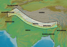
Geographically, it is surrounded by the Iranian Plateau in the west, Hindu Kush and Karakoram and Pamir ranges in the northwest, the Tibetan Plateau in the north, the Indochinese Peninsula in the east, and the Indian subcontinent in the south.

Geopolitics

The countries bordering the Himalayas ("Himalayan states") include China (Tibet in particular) to the north, Myanmar to the east, and the Northern South Asian countries of India, Bhutan, Nepal, Pakistan, and Afghanistan to the south. [1]

Various conflicts have broken out along the Himalayan Rim, such as the Chinese annexation of Tibet and the Indo-China War of 1962, [2] and in general, there are significant tensions between various neighboring countries in the region as a result of border disputes. [1]

See also

Related Research Articles

<span class="mw-page-title-main">Geography of India</span> Geographical features of India

India is situated north of the equator between 8°4' north to 37°6' north latitude and 68°7' east to 97°25' east longitude. It is the seventh-largest country in the world, with a total area of 3,287,263 square kilometres (1,269,219 sq mi). India measures 3,214 km (1,997 mi) from north to south and 2,933 km (1,822 mi) from east to west. It has a land frontier of 15,200 km (9,445 mi) and a coastline of 7,516.6 km (4,671 mi).

<span class="mw-page-title-main">Kashmir</span> Territory disputed between China, India, and Pakistan

Kashmir is the northernmost geographical region of the Indian subcontinent. Until the mid-19th century, the term "Kashmir" denoted only the Kashmir Valley between the Great Himalayas and the Pir Panjal Range. Today, the term encompasses a larger area that includes the India-administered territories of Jammu and Kashmir and Ladakh, the Pakistan-administered territories of Azad Kashmir and Gilgit-Baltistan, and the Chinese-administered territories of Aksai Chin and the Trans-Karakoram Tract.

<span class="mw-page-title-main">Geography of China</span>

China has great physical diversity. The eastern plains and southern coasts of the country consist of fertile lowlands and foothills. They are the location of most of China's agricultural output and human population. The southern areas of the country consist of hilly and mountainous terrain. The west and north of the country are dominated by sunken basins, rolling plateaus, and towering massifs. It contains part of the highest tableland on earth, the Tibetan Plateau, and has much lower agricultural potential and population.

<span class="mw-page-title-main">Sino-Indian War</span> 1962 war between China and India

The Sino–Indian War, also known as the China–India War or the Indo–China War, was an armed conflict between China and India that took place from October to November 1962. It was a military escalation of the Sino–Indian border dispute. Fighting occurred along India's border with China, in India's North-East Frontier Agency east of Bhutan, and in Aksai Chin west of Nepal.

<span class="mw-page-title-main">Himalayas</span> Mountain range in Asia, separating Indo-Gangetic plain from Tibetan Plateau

The Himalayas, or Himalaya is a mountain range in Asia, separating the plains of the Indian subcontinent from the Tibetan Plateau. The range has some of the Earth's highest peaks, including the highest, Mount Everest. More than 100 peaks exceeding elevations of 7,200 m (23,600 ft) above sea level lie in the Himalayas.

<span class="mw-page-title-main">Ladakh</span> Region administered by India

Ladakh is a region administered by India as a union territory and constitutes an eastern portion of the larger Kashmir region that has been the subject of a dispute between India and Pakistan since 1947 and India and China since 1959. Ladakh is bordered by the Tibet Autonomous Region to the east, the Indian state of Himachal Pradesh to the south, both the Indian-administered union territory of Jammu and Kashmir and the Pakistan-administered Gilgit-Baltistan to the west, and the southwest corner of Xinjiang across the Karakoram Pass in the far north. It extends from the Siachen Glacier in the Karakoram range to the north to the main Great Himalayas to the south. The eastern end, consisting of the uninhabited Aksai Chin plains, is claimed by the Indian Government as part of Ladakh, but has been under Chinese control.

<span class="mw-page-title-main">McMahon Line</span> Boundary between the Tibetan region of China and India

The McMahon Line is the boundary between Tibet and British India as agreed in the maps and notes exchanged by the respective plenipotentiaries on 24–25 March 1914 at Delhi, as part of the 1914 Simla Convention. The line delimited the respective spheres of influence of the two countries in the eastern Himalayan region along northeast India and northern Burma (Myanmar), which were earlier undefined. The Republic of China was not a party to the McMahon Line agreement, but the line was part of the overall boundary of Tibet defined in the Simla Convention, initialled by all three parties and later repudiated by the government of China. The Indian part of the Line currently serves as the de facto boundary between China and India, although its legal status is disputed by the People's Republic of China. The Burmese part of the Line was renegotiated by the People's Republic of China and Myanmar.

<span class="mw-page-title-main">Chumbi Valley</span> Valley in Yadong County, Tibet Autonomous Region, China

The Chumbi Valley, called Dromo or Tromo in Tibetan, is a valley in the Himalayas that projects southwards from the Tibetan plateau, intervening between Sikkim and Bhutan. It is coextensive with the administrative unit Yadong County in the Tibet Autonomous Region of China. The Chumbi Valley is connected to Sikkim to the southwest via the mountain passes of Nathu La and Jelep La.

<span class="mw-page-title-main">Kargil</span> Town in Indian-administered Ladakh, Kashmir region

Kargil or Kargyil is a city in Indian-administered Ladakh in the disputed Kashmir region. It is the joint capital of Ladakh, an Indian-administered union territory. It is also the headquarters of the Kargil district. It is the second-largest city in Ladakh after Leh. Kargil is located 204 kilometres (127 mi) east of Srinagar in Jammu and Kashmir, and 234 kilometres (145 mi) to the west of Leh. It is on the bank of the Suru River near its confluence with the Wakha Rong river, the latter providing the most accessible route to Leh.

<span class="mw-page-title-main">Sino-Indian border dispute</span> Border dispute between China and India

The Sino–Indian border dispute is an ongoing territorial dispute over the sovereignty of two relatively large, and several smaller, separated pieces of territory between China and India. The first of the territories, Aksai Chin, is administered by China and claimed by India; it is mostly uninhabited high-altitude wasteland but with some significant pasture lands at the margins. It lies at the intersection of Kashmir, Tibet and Xinjiang, and is crossed by China's Xinjiang-Tibet Highway; the other disputed territory is south of the McMahon Line, in the area formerly known as the North-East Frontier Agency and now a state called Arunachal Pradesh. It is administered by India and claimed by China. The McMahon Line was signed between British India and Tibet to form part of the 1914 Simla Convention, but the latter was never ratified by China. China disowns the McMahon Line agreement, stating that Tibet was not independent when it signed the Simla Convention.

<span class="mw-page-title-main">Indian Himalayan Region</span> Region in northern India

The Indian Himalayan Region is the section of the Himalayas within the Republic of India, spanning thirteen Indian states and union territories, namely Ladakh, Jammu and Kashmir, Himachal Pradesh, Uttarakhand, Sikkim, West Bengal, Manipur, Meghalaya, Mizoram, Nagaland, Tripura, Assam, and Arunachal Pradesh. The region is responsible for providing water to a large part of the Indian subcontinent and contains various flora and fauna.

The Depsang Plains, a high-altitude gravelly plain in the northwest portion of the disputed Aksai Chin region of Kashmir, divided into Indian and Chinese administered portions by a Line of Actual Control. India controls the western portion of the plains as part of Ladakh, while the eastern portion is controlled by China and claimed by India. The Line of Control with Pakistan-administered Gilgit-Baltistan is 80 kilometres (50 mi) west of the Depsang Plains, with the Siachen Glacier in-between. Ladakh's traditional trade route to Central Asia passed through the Depsang Plains, with the Karakoram Pass lying directly to its north.

<span class="mw-page-title-main">Indian subcontinent</span> Physiographical region in South Asia

The Indian subcontinent is a physiographical region in Southern Asia, mostly situated on the Indian Plate, projecting southwards into the Indian Ocean from the Himalayas. Geopolitically, it spans major landmasses from the countries of Bangladesh, Bhutan, India, the Maldives, Nepal, Pakistan, and Sri Lanka. The neighboring geographical regions around the subcontinent include the Tibetan Plateau to the north, the Indochinese Peninsula to the east, the Iranian Plateau to the west, and the Indian Ocean to the south. Although the terms "Indian subcontinent" and "South Asia" are often used interchangeably to denote the region, the geopolitical term of South Asia frequently includes Afghanistan, which is not part of the subcontinent.

The Kalapani territory is an area under Indian administration as part of Pithoragarh district in the Kumaon Division of the Uttarakhand state, but it is also claimed by Nepal since 1997. According to Nepal's claim, it lies in Darchula district, Sudurpashchim Province. The territory represents part of the basin of the Kalapani river, one of the headwaters of the Kali River in the Himalayas at an altitude of 3600–5200 meters. The valley of Kalapani, with the Lipulekh Pass at the top, forms the Indian route to Kailash–Manasarovar, an ancient pilgrimage site. It is also the traditional trading route to Tibet for the Bhotiyas of Kumaon and the Tinkar valley of Nepal.

South Tibet is a literal translation of the Chinese term '藏南', which may refer to different geographic areas:

<span class="mw-page-title-main">Gipmochi</span> Mountain in India/Bhutan

Gipmochi is a mountain in the Lower Himalayas in south central Asia. Rising to a height of 14,523 feet (4,427 m), the mountain sits on the border between the northern Indian state of Sikkim and Bhutan. China claims Gipmochi as the China–India–Bhutan tri-junction point. Bhutan and India, however, claim that the tri-junction is 6.5 km to the north, at Batang La.

<span class="mw-page-title-main">Doklam</span> Disputed area between China and Bhutan

Doklam, called Donglang by China, is an area in Bhutan with a high plateau and a valley, lying between China's Chumbi Valley to the north, Bhutan's Ha District to the east and India's Sikkim state to the west. It has been depicted as part of Bhutan in the Bhutanese maps since 1961, but it is also claimed by China. The dispute has not been resolved despite several rounds of border negotiations between Bhutan and China. The area is of strategic importance to all three countries.

<span class="mw-page-title-main">India–Nepal border</span> International boundary in South Asia

The India–Nepal border is an open international boundary running between the republics of India and Nepal. The 1,770 km (1,099.83 mi) long border includes the Himalayan territories as well as Indo-Gangetic Plain of the subcontinent. The current border was delimited after the Sugauli treaty of 1816 between Nepal and the British Raj. Following Indian independence, the prevailing border was recognised as the international border between the Kingdom of Nepal and the Dominion of India.

<span class="mw-page-title-main">Chinese irredentism</span> Irredentist claims to territories of the former Chinese Empire

Chinese irredentism involves irredentist claims to the territories of former Chinese dynasties made by the Republic of China (ROC) and subsequently the People's Republic of China (PRC).

Barahoti, also called Wu-Je or Wure, located in the 'middle sector' of the disputed Sino-Indian border, is a 1.5 square miles (3.9 km2) sloping plain situated in the Indian state of Uttarakhand, Chamoli district. It is disputed by China, which also disputes a 750 square kilometres (290 sq mi) area surrounding it. The entire disputed area also goes by the name "Barahoti", or sometimes "Barahoti–Sangchamalla–Lapthal disputed area". The entire area is on the Ganges side of the Sutlej–Ganges water divide, which is also the current Line of Actual Control between India and China.

References

  1. 1 2 Walcott, Susan M.; Johnson, Corey (2013-11-12). Eurasian Corridors of Interconnection: From the South China to the Caspian Sea. Routledge. ISBN   978-1-135-07875-1.
  2. Griffiths, Ryan D. (2016). "India and Its Many Nations". Age of secession: the international and domestic determinants of state birth (1st ed.). Cambridge New York, NY Port Melbourne Delhi Singapore: Cambridge University Press. ISBN   978-1-107-16162-7.