
Himachal Pradesh is a state in the northern part of India. Situated in the Western Himalayas, it is one of the thirteen mountain states and is characterized by an extreme landscape featuring several peaks and extensive river systems. Himachal Pradesh is the northernmost state of India and shares borders with the union territories of Jammu and Kashmir and Ladakh to the north, and the states of Punjab to the west, Haryana to the southwest, Uttarakhand to the southeast and a very narrow border with Uttar Pradesh to the south. The state also shares an international border to the east with the Tibet Autonomous Region in China. Himachal Pradesh is also known as Dev Bhoomi, meaning 'Land of Gods' and Veer Bhoomi which means 'Land of the Brave'.

Chamba district is the northwestern district of Himachal Pradesh, in India, with its headquarters in Chamba town. The towns of Dalhousie, Khajjhiar and Churah Valley are popular hill stations and vacation spots for the people from the plains of northern India.

Khajjiar is a hill station, near town of Chamba in Chamba district, Himachal Pradesh, India, located approximately 24 kilometres (15 mi) from Dalhousie.
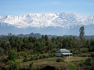
Dhauladhar is a mountain range which is part of a lesser Himalayan chain of mountains. It rises from the Shivalik hills, to the north of Kangra and Mandi. Dharamsala, the headquarters of Kangra district and the winter capital of Himachal Pradesh, lies on its southern spur in the Kangra Valley. Chamba lies to the North of this range.

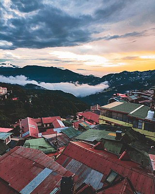
Dalhousie is a hill station, near town of Chamba in Chamba district in the Indian state of Himachal Pradesh. It is situated on five hills and has an elevation of 1,970 m (6,460 ft) above sea level.

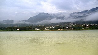
Pathankot is a city and the district headquarters of the Pathankot district in Punjab, India. Pathankot is the 6th most populous city of Punjab, after Ludhiana, Amritsar, Jalandhar, Patiala and Bathinda. Its local government is a municipal corporation.

Shimla district is one of the twelve districts of the state of Himachal Pradesh in northern India. Its headquarters is the state capital of Shimla. Neighbouring districts are Mandi and Kullu in the north, Kinnaur in the east, Uttarakhand in the southeast, Solan to the southwest and Sirmaur in the south. The elevation of the district ranges from 987 metres (3,238 ft) to 4,500 metres (14,764 ft).
Dalhousie cantonment is a town in Chamba district in the state of Himachal Pradesh, India.
Gobind Sagar Lake is a reservoir situated in Una and Bilaspur districts of Himachal Pradesh, India. It is formed by the Bhakra Dam.

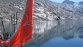
Manimahesh Lake is a high altitude lake situated close to the Manimahesh Kailash Peak in the Pir Panjal Range of the Himalayas, in the Bharmour subdivision of Chamba district of the Indian state of Himachal Pradesh. The religious significance of this lake is next to that of the Lake Manasarovar in Tibet.
Lam Dal or Laam Dal is a high altitude lake located in Piura Dhar of Chamba district in Himachal Pradesh, India. It is situated 45 km from the town of Chamba at an elevation of about 3,960 metres (12,990 ft) above the sea level.
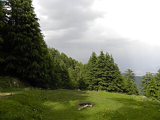
Kalatop Khajjiar Sanctuary, or simply Kalatop Sanctuary, is a 30.69 km² animal sanctuary at Kalatop and Khajjiar in the Chamba district of Himachal Pradesh, India. The sanctuary area is well laid out for trekking trails both at Kalatop and Khajjiar. There is a dense deodar and fir forest covering 19.63 km² of the sanctuary, which is about 6 km from Dalhousie. Pheasants, serow and black bear are some of the common animals found here. The sanctuary lies in the path of the Ravi River, and is surrounded by coniferous and oak forests.

Banikhet is located about seven kilometers from Dalhousie, India. It is an important centre of tourism in the Chamba district.
Dharwas is the northernmost town of the state of Himachal Pradesh in India. It is located in the Chamba District at an elevation of 8,000 ft (2,400 m) above sea level. Dharwas is the largest and most populated area in the Pangi Valley, and trekking base camps are available for those on the Dalhousie-Kishtwar trekking route.

Sach Pass is a 4,414-metre-high (14,482 ft) mountain pass in Chamba District, Himachal Pradesh, India on the Pir Panjal range of the Himalayas. It is 127 km (79 mi) from the District Headquarters. It connects the Chamba valley with the Pangi valleys of Himachal Pradesh, India. There is a helipad on the ascent towards Sach pass from Bairagarh of Himachal Pradesh.

The Manimahesh Kailash Peak, 5,653 metres (18,547 ft), also known as Chamba Kailash, which stands towering high over the Manimahesh Lake, is believed to be the abode of Lord Shiva, the. It is located in the Bharmour subdivision of the Chamba district in the Indian state of Himachal Pradesh. The peak is 26 kilometres (16 mi) from Bharmour in the Budhil valley. It is one of the major pilgrimage sites as well as a popular trekking destination in Himachal Pradesh. The Manimahesh Lake is at the base of the Kailash peak at 3,950 metres (12,960 ft) and is also held in deep veneration by people of Himachal Pradesh, particularly the Gaddi tribe of the region. In the month of Bhadon, on the eighth day of the new moon period a fair is held in the precincts of the lake that attracts thousands of pilgrims.
Salooni is the tehsil headquarter and Sub-Division in Chamba district of Himachal Pradesh, India. Salooni is an important regional administrative and economic centre. It has a mini secretariat, SDM office, government senior secondary school, Degree College, community health centre and many other sub-division level important government offices. Salooni falls under Dalhousie legislative constituency. The entrance to the small township has a series of few quaint shops, followed by small ground with an ancient goddess Kali temple at other end.

Pangi is a tehsil of Chamba, Himachal Pradesh, India. The Pangi Valley is a beautiful and poorly developed tribal area, as well as one of the most remote areas in Himachal Pradesh state. The Pangi Valley is divided into the Saichu, Hudan Bhatori, Anch Chaloli and Sural Bhatori valleys, which are inhabited at elevations of 7,000 feet (2,100 m) to 11,000 feet (3,400 m) above sea level. The Valley is bordered by Padder, Jammu and Kashmir in North, Lahaul and Spiti in West and Chamba in Southeast. The Sach Pass at the elevation of 4,414m is the only route connecting Pangi with District headquarter Chamba.
Tourism in Himachal Pradesh relates to tourism in the Indian state of Himachal Pradesh. This is popularly renowned for its Himalayan landscapes and popular hill-stations. Many outdoor activities such as rock climbing, mountain biking, paragliding, ice-skating, trekking, rafting, and heli-skiing are popular tourist attractions in Himachal Pradesh.

