Kullu Valley

Last updated

Kullu Valley
Kulu Valley
Himalayas from Kullu Valley, Himachal Pradesh.jpg
Kullu Valley
Geology
Type River Valley
Geography
Location Himachal Pradesh in India
Population centers Kullu
Coordinates 31°57′28″N77°6′34″E / 31.95778°N 77.10944°E / 31.95778; 77.10944 Coordinates: 31°57′28″N77°6′34″E / 31.95778°N 77.10944°E / 31.95778; 77.10944
Rivers Beas River

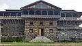
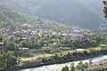
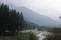
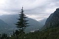
Kullu Valley is a broad open valley in Himachal Pradesh, India, formed by the Beas River between Manali and Larji. [1] This valley is famous for its temples, beauty and its majestic hills covered with pine and deodar forest and sprawling apple orchards. The course of the Beas river presents a succession of magnificent, clad with forests of deodar, towering above trees of pine on the lower rocky ridges. Kullu valley is sandwiched between the Pir Panjal, Lower Himalayan and Great Himalayan Ranges. [2] Ski touring is a sport growing in popularity in the Himilayan peaks surrounding the valley. [3]

Contents

Economy

See Economy section in Kullu district.

Tourism

For places of interest, festivals, and outdoor sports in the Kullu valley, see Attractions section in Kullu district.

Further reading

See Further Readings section in Kullu district.

Related Research Articles

Kullu is a district in Himachal Pradesh, India. It borders Rampur district to the south, Mandi and Kangra districts to the west, and the Lahaul and Spiti district to the north and east. The largest valley in this mountainous district is the Kullu Valley. The Kullu valley follows the course of the Beas River, and ranges from an elevation of 833m above sea level at Aut to 3330m above sea level at the Atal Tunnel South Portal, below the Rohtang Pass. The town of Kullu, or simply Kullu, located on the right side of the Beas River, serves as the administrative headquarters of the Kullu district. The Kullu district also incorporates several riverine tributary valleys of the Beas, including those of the Parvati, Sainj, and Tirthan rivers, and thus some regions somewhat distant from the Kullu valley. The economy of the district relies mainly on horticulture, agriculture, tourism, and traditional handicrafts.

<span class="mw-page-title-main">Rohtang Pass</span> Mountain pass

Rohtang Pass is a high mountain pass on the eastern end of the Pir Panjal Range of the Himalayas around 51 km (32 mi) from Manali in the Indian state of Himachal Pradesh. It connects the Kullu Valley with the Lahaul and Spiti Valleys of Himachal Pradesh, India.

<span class="mw-page-title-main">Manali, Himachal Pradesh</span> Town in India

Manali is a town in the Indian state of Himachal Pradesh. It is situated in the northern end of the Kullu Valley, formed by the Beas River. The town is located in the Kullu district, approximately 270 kilometres (170 mi) north of the state capital of Shimla and 544 kilometres (338 mi) northeast of the national capital of Delhi. With a population of 8,096 people recorded in the 2011 Indian census Manali is the beginning of an ancient trade route through Lahaul and Ladakh, over the Karakoram Pass and onto Yarkand and Hotan in the Tarim Basin of China. Manali is a popular tourist destination in India and serves as the gateway to the Lahaul and Spiti district as well as the city of Leh in Ladakh.

<span class="mw-page-title-main">Dhauladhar</span> Himalayan mountain range

Dhauladhar is a mountain range which is part of a lesser Himalayan chain of mountains. It rises from the Shivalik hills, to the north of Kangra and Mandi. Dharamsala, the headquarters of Kangra district and the winter capital of Himachal Pradesh, lies on its southern spur in the Kangra Valley. Chamba lies to the North of this range.

<span class="mw-page-title-main">Parvati Valley</span>

Parvati Valley is situated in the northern Indian state of Himachal Pradesh. From the confluence of the Parvati River with the River Beas, the Parvati Valley runs eastwards, through a steep-sided valley from the town of Bhuntar, in the Kullu district of Himachal Pradesh in Northern India.

<span class="mw-page-title-main">Kullu</span> Town in Himachal Pradesh, India

Kullu is a municipal council town that serves as the administrative headquarters of the Kullu district of the Indian state of Himachal Pradesh. It is located on the banks of the Beas River in the Kullu Valley about 10 kilometres (6.2 mi) north of the airport at Bhuntar.

<span class="mw-page-title-main">Pir Panjal Range</span> Mountain range of the Lower Himalayas

The Pir Panjal Range is a group of mountains in the Lesser Himalayan region, running from east-southeast (ESE) to west-northwest (WNW) across the Indian territories of Himachal Pradesh and Jammu and Kashmir and then Pakistan's Azad Kashmir and Punjab. The average elevation varies from 1,400 m (4,600 ft) to 4,100 m (13,500 ft). The Himalayas show a gradual elevation towards the Dhauladhar and Pir Panjal ranges. Pir Panjal is the largest range of the Lesser Himalayas. Near the bank of the Sutlej River, it dissociates itself from the Himalayas and forms a divide between the Beas and Ravi rivers on one side and the Chenab on the other. The renowned Galyat mountains are also located in this range.

<span class="mw-page-title-main">Great Himalayan National Park</span> National park in Himachal Pradesh, India

The Great Himalayan National Park (GHNP) is a national park in India, located in Kullu region in the state of Himachal Pradesh. The park was established in 1984 and is spread over an area of 1171 km2; altitudes within the park range between 1500 and 6000 m. The Great Himalayan National Park is a habitat to numerous flora and more than 375 fauna species, including approximately 31 mammals, 181 birds, 3 reptiles, 9 amphibians, 11 annelids, 17 mollusks and 127 insects. They are protected under the strict guidelines of the Wildlife Protection Act of 1972; hence any sort of hunting is not permitted.

<span class="mw-page-title-main">Naggar</span> Town in Himachal Pradesh, India

Situated on the left bank of river Beas at an altitude of 1,800 meters, Naggar is an ancient town in Kullu district of Himachal Pradesh, India. It was once capital of the Kullu kingdom.

<span class="mw-page-title-main">Geography of Himachal Pradesh</span>

The state of Himachal Pradesh is spread over an area 55,673 km2 (21,495 sq mi) and is bordered by Jammu and Kashmir and Ladakh on the north, Punjab on the southwest, Haryana on the south, Uttarakhand on the southeast, a small border with Uttar Pradesh in the south, and Tibet on the east. Entire Himachal Pradesh lies in the mountainous Himalaya region, rich in natural resources

<span class="mw-page-title-main">Banjar, India</span> Place in Himachal Pradesh, India

Banjar is a town in Kullu district in the state of Himachal Pradesh, India. Banjar is one of the sixtehsils of Kullu district. Culturally, it is a part of the Seraj region that extends from Jalori pass to Shikari Devi in Janjehli. A dialect of Kullavi called Seraji is spoken in the region and the natives are also called Serajis. The tourist attractions of Tirthan valley and Jibhi are a part of the Banjar region with Banjar town being the main marketplace in Tirthan Valley.

<span class="mw-page-title-main">Jogindernagar</span> Municipality and Hill Station in Himachal Pradesh, India

Jogindernagar, or Jogindar Nagar, is a municipality, and a sub district in Mandi district in the Indian state of Himachal Pradesh. Named after Raja Joginder Sen, the hill station is the terminus of the 163-kilometre-long (101 mi) Kangra Valley narrow-gauge railway. Jogindernagar is the third-largest city in the Mandi district. The only city in Asia with three hydro-electric power stations, its nickname is "The City of Powerhouses".

<span class="mw-page-title-main">Spiti</span> River valley in Himachal Pradesh

Spiti is a high-altitude region of the Himalayas, located in the north-eastern part of the northern Indian state of Himachal Pradesh. The name "Spiti" means "The middle land", i.e. the land between Tibet and India. Spiti incorporates mainly the valley of the Spiti river, and the valleys of several rivers that feed into the Spiti river. Some of the prominent side-valleys in Spiti are the Pin valley and the Lingti valley. Spiti is bordered on the east by Tibet, on the north by Ladakh, on the west and southwest by Lahaul, on the south by Kullu, and on the southeast by Kinnaur. The valley and its surrounding regions are among the least populated regions of India. Spiti has a cold desert environment. The Bhoti-speaking local population follows Tibetan Buddhism.

According to the Mahabharta, the present day Himachal Pradesh consisted of a number of small republics also known as the Janpadas..

  1. Audumbras – They were one of the most ancient tribes of Himachal who resided in the lower hills of Pathankot and Jwalamukhi. They formed a separate province in 2 B.C.
  2. Trigarta – The state was laid in the foothills drained by 3 rivers, namely- Ravi, Beas and Satluj. It is believed that the state was an independent republic.
  3. Kuluta – The kingdom of Kuluta was located in the upper Beas valley which is also known as the Kullu valley. The state capital was Naggar.
  4. Kulindas – The kingdom covered the area between the Beas, Satluj and Yamuna rivers. The administration resembled a republic with the members of central assembly sharing the powers of the head.
  5. Guptas – Chandragupta captured the republics of the Himachal by the use of his force though he usually did not rule them directly. Ashoka, his grandson extended his boundaries to the Himalayan region. He introduced Buddhism to the state. He built various stupas here.
  6. Harsha – After the collapse of Guptas and before the rise of Harsha, the area was again ruled by chiefs also known as Thakurs and Ranas. With the rise of Harsha in the 7th century, most of these small provinces acknowledged its allround supremacy though many local powers remained with the chiefs.
  7. Rajput Period – After Harsha's death Rajput states ascended in Rajasthan and Indus plains. They moved to the hills with their followers, where they established small provinces or principalities. Some of these were Kangra, Nurpur, Suket, Mandi, Kutlehar, Baghal, Bilaspur, Nalagarh, Keonthal, Dhami, Kunihar, Bushahar, Sirmour.
<span class="mw-page-title-main">Barot, Himachal Pradesh</span> Town Valley in Himachal Pradesh, India

Barot, a village originally developed in 1920s for Shanan Hydel Project, is now a tourist location in Mandi district in the Indian state of Himachal Pradesh. Barot was difficult to access until 1975, when a road was opened. It is situated 40 km from Jogindernagar and 65 km from Mandi, the District Headquarter. The road to Barot branches off at Jogindernagar-Mandi Highway and from Jogindernagar the distance is 40 km. It is sometimes possible to use the funicular trolley from Jogindernagar which reduces the distance to 12 km. The road route includes terraced fields and thick cedar forests, rising to Jhatingri at the hilltop. The remains of the summer palace of the former rulers of Mandi are located here. Through the little village of Tikkan, the road carries on to Barot. The town has a range of outdoor activities, including a trout breeding centre, from where fish are released into the Uhl river. A 30 km section of the river is used for angling.

<span class="mw-page-title-main">Mandi, Himachal Pradesh</span> City in Himachal Pradesh, India

Mandi is a major city and a municipal corporation in Mandi District in the Indian state of Himachal Pradesh.

<span class="mw-page-title-main">Western Himalayas</span> Western section of the Himalayas

The Western Himalayas refers to the western half of the Himalayas, in northern Pakistan and northwestern India. It is also known as the Punjab Himalayas. Four of the five tributaries of the Indus River in Punjab rise in the Western Himalayas; while the fifth, the Sutlej cuts through the range after rising in Tibet.

<span class="mw-page-title-main">Tourism in Himachal Pradesh</span> Tourism in the Indian state of Himachal Pradesh

Tourism in Himachal Pradesh relates to tourism in the Indian state of Himachal Pradesh. This is popularly renowned for its Himalayan landscapes and popular hill-stations. Many outdoor activities such as rock climbing, mountain biking, paragliding, ice-skating, trekking, rafting, and heli-skiing are popular tourist attractions in Himachal Pradesh.

Hamta Pass is a corridor in the Himalayas, between the Chandra Valley in Lahaul and the Kullu valley of Himachal Pradesh, India. The pass is named after Hamta Village, below Sethan village. Lower Himalayan shepherds use the pass in summer for its high altitude grasslands in the summer, when the desert of Lahaul is barren.

<span class="mw-page-title-main">Naggar Castle</span> Medieval castle, located in Kullu, Himachal Pradesh, India

Naggar Castle is a medieval castle, located in Kullu, Himachal Pradesh, India. Built by Raja Sidh Singh of Kullu in around 1460 A.D, it was taken over to Himachal Pradesh Tourism Development Corporation (HPTDC), to run as a heritage hotel, since 1978.

References

  1. CIL. "Exhibition - Malana - A Lost Utopia in the Himalayas". ignca.nic.in. Archived from the original on 3 March 2016. Retrieved 20 September 2017.
  2. PRADESH, HIMACHAL. "Mythological references and evidances - Kullu District Official Website, Himachal Pradesh". himachal.gov.in. Retrieved 20 September 2017.
  3. Spooner, Campbell (2002). Ski Touring India's Kullu Valley. Canada: Alpine Touring Publishing. p. 160. ISBN   0958108609.