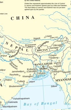
Since India's 1947 independence, 98% of Northeast India's borders have been with other Asian countries, making it a strategic frontier region. [1] The East Asian countries of Japan and Korea have significant contemporary influence over and cultural similarities with Northeast India; Northeast India engages to a significant extent with Korean and Japanese culture and has been receiving infrastructural investment from Japan. Northeast India also has substantial historical connections to Southeast Asia; India's Act East policy seeks to harness this connectivity in the modern day. [2]
China claims the border state of Arunachal Pradesh as part of South Tibet, which has resulted in tensions between India and China. [3] Since 2009, China has issued "stapled visas" to people from Arunachal Pradesh when they wish to travel to China, signaling that they are perceived as having the same right of movement as Chinese citizens throughout China. [4]
In the late 19th century, the British sent an expedition to guarantee suzerainty in Sikkim, aiming to secure it from Tibet. [5] In postcolonial times, China had a dispute over the status of Sikkim, which acceded to India in 1975, until 2003. [6] However, 21st century border clashes have occurred between India and China in the region. [7]
Historically, Northeast India and Japan have been connected to some extent through Buddhism; other cultural similarities have existed for millennia, such as in food and through an appreciation for nature. [8] [9] During World War 2, the Japanese military collaborated with the Indian National Army in the region; [10] eventually, the westward expansion of the Japanese Empire was put to a stop in Northeast India in the 1944 Battle of Imphal. Since then, Japan has contributed to the construction of infrastructure in the region. [11] Northeast Indians consume some Japanese cultural products as well, such as anime. [8]
Northeast India is currently being prioritized by India and Japan as part of Japan's Free and Open Indo-Pacific strategy and as part of India's Act East policy, [12] with both countries seeing the region as especially important for creating trading routes due to their collective rejection of China's Belt and Road Initiative. [13] Northeast India, in conjunction with the neighboring BIMSTEC country of Bangladesh, is seen by Japan as an important region in containing China, [14] [15] while India seeks to use its northeastern region to increase engagement with Southeast Asia. [15] The geographical similarities between Northeast India and Japan, as well as India's guarding of its northeast as a sensitive border region that it is unwilling to allow untrusted partner countries to invest in, are other major factors leading to India desiring Japan's involvement in the region. [16] [17]
Northeast India has often felt alienated from the rest of India (sometimes referred to as "mainland India"), leading it in recent decades to look towards phenotypically and culturally similar parts of Asia in the east for connection. Part of this alienation is due to local insurgents and others banning Hindi cinema and other potential tools of "Indianization" in the region. [18] [19] [20] In this context, Korean culture has become popular in Northeast India, with Korean words becoming increasingly prevalent in the local languages. [21] Korean food has also become increasingly popular at local restaurants. [22] The popularity of Korean culture that emerged in Northeast India has since spread to the rest of India in recent years. [20] One aspect of Korean culture's popularity in Northeast India is its ability to incorporate Christian principles in a non-Western manner, making it more relatable in some ways to Northeast Indian youth than Western culture. [23]
There are some similarities between the cultures of Manipur and Mongolia, as can be seen in music, wrestling, and various traditions and age rituals. [24]
Taiwan has looked into hiring Northeast Indians over other Indians, citing similarities in ethnicity and culture. [25]
Northeast India is dependent on Bangladesh to some extent for routes to Southeast Asia. Assam, Meghalaya, and Tripura depend on having access to the sea via Bangladesh’s Chittagong port. Initiatives for connectivity, like the Kaladan Multi-Modal Transit Transport Project and the Akhaura–Agartala line, are also relevant. [26]
Immigration from Bangladesh has been a concern for indigenous populations in Northeast India, which oppose significant demographic change. This immigration has led to historical movements such as the Assam Movement of the 1980s. [27]
Bhutan helped open up air routes from Northeast India to Southeast Asia in 2018. [28] In the same year, Bhutan also opened its second consulate in the easternmost portions of India in Guwahati, Assam. [29]
Present-day Northeast India started to be annexed into British India in the early 19th century to defend the eastern frontier from the incursions of the Burmese Empire, with Assam becoming part of the Bengal Presidency until 1874. [30] The treatment of the Northeast as separate from the rest of India during the colonial era has continued to negatively impact its integration into the Republic of India. [31]
Some retired Nepali troops settled in Northeast India during the colonial era. In the present day, there has been some indigenous backlash to the Nepali diaspora. [32]
Sikkim's 1975 accession to India was influenced by its ties to Nepal, as its ethnically Nepali population felt discriminated against by the Sikkimese government and sought better treatment by joining India. [33]
India has sought to use Northeast India to connect to Southeast Asia for trading purposes. However, recent conflicts such as the 2023–2024 Manipur violence have reduced the stability of the region for this purpose. [34]
Myanmar is the only Southeast Asian country that borders Northeast India. Both places were part of British India for several decades; the dynamics of British rule in the region, which was the first time that a pan-Indian empire had fully conquered the Northeastern South Asian space, and Myanmar's 1937 separation from Indian administration, still affect their border regions today. [35] [36]
There are substantial cross-border ethnic ties, with the Indian government having allowed a limited amount of unregulated movement across the border from 2018 to 2024. [37]
The Tai peoples of Northeast India share ethnic and linguistic ties with Thai people. There are also analogues of Thailand’s Songkran festival in Northeast India (Sangken in Arunachal Pradesh and Bohag Bihu in Assam). [38]
Northeast India, officially the North Eastern Region (NER), is the easternmost region of India representing both a geographic and political administrative division of the country. It comprises eight states—Arunachal Pradesh, Assam, Manipur, Meghalaya, Mizoram, Nagaland and Tripura, and the "brother" state of Sikkim.
The Siliguri Corridor, also known as the Chicken's Neck, is a stretch of land around the city of Siliguri in West Bengal, India. 20–22 kilometres (12–14 mi) at the narrowest section, this geo-political and geo-economical corridor connects the seven states of northeast India to the rest of India. The countries of Nepal and Bangladesh lie on each side of the corridor and the Kingdom of Bhutan lies at the northern end of the corridor. The Kingdom of Sikkim formerly lay on the northern side of the corridor, until its merger with India in 1975.
The Insurgency in Northeast India involves multiple separatist and jihadist militant groups operating in some of India's northeastern states, which are connected to the rest of India by the Siliguri Corridor, a strip of land as narrow as 14.29 miles (23.00 km) wide.
UTC+06:00 is an identifier for a time offset from UTC of +06:00. This time is used in:
The Ministry of Development of North Eastern Region is a Government of India ministry, established in September 2001, which functions as the nodal Department of the Central Government to deal with matters related to the socio-economic development of the eight States of Northeast India: Arunachal Pradesh, Assam, Manipur, Meghalaya, Mizoram, Nagaland, Tripura and Sikkim. It acts as a facilitator between the Central Ministries/ Departments and the State Governments of the North Eastern Region in the economic development including removal of infrastructural bottlenecks, provision of basic minimum services, creating an environment for private investment and to remove impediments to lasting peace and security in the North Eastern Region.
The rufous-chinned laughingthrush is a bird species in the family Leiothrichidae. It ranges across the northern parts of the Indian subcontinent and some parts of Southeast Asia.
The Trans-Arunachal Highway (TAH), which includes an existing 1,811 km (1,125 mi) route comprising NH-13 and parts of NH-15, NH-215 and SH-25, is an under-construction 2-lane more than 2,407 km (1,496 mi) long highway passing through 16 districts in Arunachal Pradesh state in India. It runs from LAC in Tawang in northwest to Kanubari in southeast at the tri-junction of Assam-Nagaland-Arunachal Pradesh. It connects at least 16 districts of Arunachal Pradesh.
The 2009 Bhutan earthquake occurred on 21 September at 14:53 BTT in the eastern region of Bhutan with moment magnitude of 6.1. The epicenter was situated at 180 kilometres (110 mi) east of the capital Thimphu, in Monggar District. However, Bangladesh and northern India also felt it, with residents in Guwahati, Assam reporting cracks in buildings. The tremors were felt as far as Tibet.
There are several disputed territories of India. A territorial dispute is a disagreement over the possession or control of land between two or more sovereign states or over the possession or control of land by a new state and occupying power after it has conquered the land from a former state no longer currently recognized by the new state.
Zanthoxylum acanthopodium, or andaliman, is a species of flowering plant in the family Rutaceae. Its range includes southern western China, Bangladesh, Bhutan, northern India and northeastern India, Nepal, Laos, Burma, northern Thailand, Vietnam, Indonesia, and Peninsular Malaysia.
Arunachal Frontier Highway (AFH), officially notified as the National Highway NH-913 and also called Bomdila-Vijaynagar Highway (BVH), connecting Bomdila Airstrip ALG & HQ in northwest to Vijaynagar Airstrip ALG & HQ in southeast via Nafra HQ-Sarli HQ-Huri Helipad ALG & HQ-Nacho HQ-Mechuka Airstrip ALG & HQ-Monigong HQ-Jido -Hunli HQ-Hayuliang Airstrip ALG HQ-Chenquenty-Hawai HQ-Miao HQ including 800 km greenfield section and network of new tunnels & bridges, is a 2-lane paved-shoulder under-construction national highway along the India-China LAC-McMahon Line border in the Indian state of Arunachal Pradesh. The 1,748 km-long (1,086 mi) highway itself will cost ₹27,000 crore and total cost including 6 additional inter-corridors is ₹40,000 crore. In some places, this highway will run as close as 20 km from the LAC. To be constructed by MoRTH in 9 packages, all packages will be approved by the end of FY 2024-25 and construction will be completed in 2 years by 31 March 2027. Of the total route, 800km is greenfield, rest brownfield will be upgraded and tunnels will be built. This highway in the north & east Arunachal along the China border would complement the Trans-Arunachal Highway and the Arunachal East-West Corridor as major highways spanning the whole state, pursuing the Look East connectivity policy.
The North-East Democratic Alliance is a political coalition that was formed on May 24, 2016, by Bharatiya Janata Party. The motive of the new political front was to unite non-Congress parties in Northeast India. Himanta Biswa Sarma was appointed as the convenor of the front.
Eastern South Asia is a subregion of South Asia. It includes the countries of Bangladesh, Bhutan, India, and Nepal. Geographically, it lies between the Eastern Himalayas and the Bay of Bengal. Two of the world's largest rivers, the Ganges and the Brahmaputra, flow into the sea through Eastern South Asia. The region includes the world's highest mountainous terrain and the world's largest delta, and has a climate ranging from alpine and subalpine to subtropical and tropical. Since Nepal, Bhutan, and northeast India are landlocked, the coastlines of Bangladesh and East India serve as the principal gateways to the region.
The Republic of India shares borders with several sovereign countries; it shares land borders with China, Bhutan, Nepal, Pakistan, Bangladesh, and Myanmar. Bangladesh, Myanmar, and Pakistan share both land borders as well as maritime borders, while Sri Lanka shares only a maritime border through Ram Setu. India's Andaman and Nicobar Islands share a maritime border with Thailand, Myanmar, and Indonesia.
The hill tribes of Northeast India are hill people, mostly classified as Scheduled Tribes (STs), who live in the Northeast India region. This region has the largest proportion of scheduled tribes in the country.
Chinese irredentism involves irredentist claims to the territories of former Chinese dynasties made by the Republic of China (ROC) and subsequently the People's Republic of China (PRC).
The India–Myanmar border is the international border between India and Myanmar. The border is 1,643 kilometres (1,021 mi) in length and runs from the tripoint with China in the north to the tripoint with Bangladesh in the south.
Border infrastructure along the Sino-Indian border, which has several border areas disputed by both India and China, encompasses irrigation, roads, railways, airports, natural gas and oil pipelines, electricity grids, telecommunications, and broadcasting. In the context of the border tensions between India and China, many of these infrastructure projects in the borderlands are considered strategic in nature. Commentators have noted the infrastructure gap that existed, and still exists, between the infrastructure on the borderlands of India and China. For many decades, the approach taken to the construction of border infrastructure by China and India was significantly different, however, in terms of utilizing the natural resources of the borderlands for the needs of the country, both countries are said to have a similar approach.
North Eastern Railway Connectivity Project is an multi phased railway connectivity project in Northeast India which comprises states of Arunachal Pradesh, Assam, Manipur, Meghalaya, Mizoram, Nagaland and Tripura and it also includes the state of Sikkim. These states come under Northeast Frontier Railway Zone of Indian Railways. This Railway project is considered as strategically important for India because it connects all the border states in this region and also close to ASEAN countries.
The North East Students' Organization (NESO) is an umbrella body representing various student organizations across the eight northeastern states of India. Established in 1979, NESO advocates for the rights, culture, and development of the indigenous peoples of the region.
{{cite web}}
: CS1 maint: multiple names: authors list (link)