
Agartala is the capital and the largest city of the Indian state of Tripura, situated on the banks of Haora River, about 2 kilometres (1.2 mi) east of the border with Bangladesh and about 2,499 km (1,52 mi) from the national capital, New Delhi. According to 2022 census, Agartala is the second-most populous city in Northeast India with a population of about 5.7 lakh. It is India's third international internet gateway and being developed under the Smart Cities Mission.

The State of Tripura has a long history. The Twipra Kingdom at its peak included the whole eastern region of Bongal from the Brahmaputra River in the north and west, the Bay of Bengal in the south and Burma to the east during the 14th and 15th centuries AD.

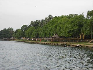
Udaipur (/ˈuːdaɪˌpʊə/), formerly known as Rangamati, is the third biggest urban area in the Indian state of Tripura. The town was a capital of the state during the reign of the Manikya Dynasty. It is famous for the Tripura Sundari temple also known as Tripureswari temple, one of the 51 Shakti Peethas. It is a Municipal Council in Gomati district & also the headquarters of Gomati district. Udaipur is about 51 km from Agartala, the capital of Tripura.
Amarpur is a town and a Nagar Panchayat in Gomati district in the Indian state of Tripura. The City was named after King Amar Manikya. Amarpur is also the headquarters of Amarpur sub-division.

Tripura Sundari Temple is a Hindu temple of the Goddess Tripura Sundari, better known locally as Devi Tripureshwari. The temple is situated in the ancient city of Udaipur, about 55 km from Agartala, Tripura and can be reached by train and road from Agartala. It is believed to be one of the holiest Hindu shrines in this part of the country and witnesses the highest number of visitors for a temple in North-East India, after Kamakhya Temple in Assam. The state of Tripura is named after this temple. Popularly known as Matabari, the shrine is set upon a small hillock that resembles the hump of a tortoise (Kurma). This shape called Kurmapṛṣṭhākṛti is considered the holiest possible site for a Shakti temple, hence also bestowing the name of Kurma Pīṭha. The Goddess is served by traditional Brahmin priests.
The Twipra Kingdom was one of the largest ancient - historical kingdoms of the Tripuri people in Northeast India.
Dighinala is an upazila of Khagrachari District in the Division of Chittagong, Bangladesh.

Narsinghgarh is a town and a municipality, near Rajgarh city in Rajgarh district in the Indian state of Madhya Pradesh.

Lake Pichola, situated in Udaipur city in the Indian state of Rajasthan, is an artificial fresh water lake, created in the year 1362, named after the nearby Picholi village. It is one of the several contiguous lakes, and developed over the last few centuries in and around the famous Udaipur city. The lakes around Udaipur were primarily created by building dams to meet the drinking water and irrigation needs of the city and its neighbourhood. Two islands, Jag Niwas and Jag Mandir are located within Pichola Lake, and have been developed with several palaces to provide views of the lake.

Shamsher Gazi, also known as the Tiger of Bhati, was a ruler of Roshnabad and Tripura, which covers parts of modern-day Bangladesh and India. Gazi's reign (1748-1760) has been cited as the "most interesting episode" in Medieval Tripura's history.
Gomati district is a district of Tripura, India. This district was created in January 2012 when four new districts were created in Tripura, taking the number of districts in the state from four to eight. Udaipur is its headquarters.
Dharmasagar is a man-made water body in Comilla, Bangladesh. The pond was dug by the Tripura king Dharma Manikya I in 1458.

Melaghar is a small town located in the Indian state of Tripura and a Municipal Council in Sipahijala district, situated about 50 km from the capital Agartala. It is a neighbour to Sonamura and 10 km away from the Bangladesh International border. Neermahal is a famous tourist attraction in the town, situated in the middle of Rudrasagar Lake.

Kasbeswari Kali Mata or Kamalasagar Kali Temple was built on a hill-top by Maharaja Dhanya Manikya in the late 15th century. It is situated just beside the Bangladesh border, The lake, Kamalasagar, in front of this temple rightly enhances its beauty.

Vijaya Manikya II, also spelt Vijay or Bijoy, was the Maharaja of Tripura from 1532 to 1563. Succeeding to the throne at a young age, Vijaya proved himself to be a formidable military leader, initiating a series of conquests into several surrounding kingdoms, including the powerful Bengal Sultanate. During Vijaya's reign, the might and influence of Tripura reached its zenith, leading to him being viewed as one of its greatest monarchs.
Ratna Manikya II was the Maharaja of Tripura from 1685 to 1693 and again from 1695 to 1712.
Amar Manikya was the Maharaja of Tripura from 1577 to 1586.
Joy Manikya II was the Maharaja of Tripura during the mid-18th-century. He originally gained the throne through popular approval for his military hostility to the Mughal Empire. However, Joy spent much of his reign warring against various relations to maintain his grip on it, in particular with his cousin Indra Manikya II.

The Kingdom of Bhulua was a kingdom and later a zamindari covering the present-day Noakhali region of Bangladesh. Its establishment is generally credited to Bishwambhar Sur, a Hindu Rajput of Mithila who passed by the area during a pilgrimage. The kingdom fell under Tripura vassalage in the 15th century, and was reduced to a zamindari (fiefdom) after losing to the Mughals. Most of the kingdom's land has been eroded by the Meghna River.


