Mainland India

Last updated
Jammu and Kashmir in India.png
India Pakistan China Disputed Areas Map.png
Northeast India.svg
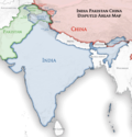
India's international borders in Kashmir (left) and Northeast India (right), outside of mainland India, are disputed by Pakistan and China (centre).

Mainland India is a geo-political term sometimes used to refer to India excluding the region of Northeast India and the disputed territory of Kashmir, [1] with the north-east connected by the Siliguri Corridor. [2] [3] [4] [5] [6]

Contents

In a geographical context, Mainland India includes the entirety of India (including Northeast India) in continental Asia, excluding islands such as the union territories of Andaman and Nicobar Islands and Lakshadweep.

Geopolitical term

Mainland India has been noted for having neglected Northeast India to a significant extent due to the Northeast's distinctness, [7] with the Northeast having become somewhat alienated as a result, [4] [8] and ending up trending towards Korean cultural influences as a result. [9]

See also

Related Research Articles

<span class="mw-page-title-main">Geography of India</span>

India is situated north of the equator between 8°4' north to 37°6' north latitude and 68°7' east to 97°25' east longitude. It is the seventh-largest country in the world, with a total area of 3,287,263 square kilometres (1,269,219 sq mi). India measures 3,214 km (1,997 mi) from north to south and 2,933 km (1,822 mi) from east to west. It has a land frontier of 15,200 km (9,445 mi) and a coastline of 7,516.6 km (4,671 mi).

<span class="mw-page-title-main">Kashmir</span> Region in South Asia

Kashmir is the northernmost geographical region of the Indian subcontinent. Until the mid-19th century, the term "Kashmir" denoted only the Kashmir Valley between the Great Himalayas and the Pir Panjal Range. Today, the term encompasses a larger area that includes the India-administered territories of Jammu and Kashmir and Ladakh, the Pakistan-administered territories of Azad Kashmir and Gilgit-Baltistan, and the Chinese-administered territories of Aksai Chin and the Trans-Karakoram Tract.

<span class="mw-page-title-main">Himalayas</span> Mountain range in Asia, separating Indo-Gangetic plain from Tibetan Plateau

The Himalayas, or Himalaya is a mountain range in Asia, separating the plains of the Indian subcontinent from the Tibetan Plateau. The range has some of the Earth's highest peaks, including the highest, Mount Everest. More than 100 peaks exceeding elevations of 7,200 m (23,600 ft) above sea level lie in the Himalayas.

Mainland is defined as "relating to or forming the main part of a country or continent, not including the islands around it [regardless of status under territorial jurisdiction by an entity]." The term is often politically, economically and/or demographically more significant than politically associated remote territories, such as exclaves or oceanic islands situated outside the continental shelf.

<span class="mw-page-title-main">Indo-Pacific</span> Biogeographic marine region of Earth

The Indo-Pacific is a vast biogeographic region of Earth.

<span class="mw-page-title-main">Subregion</span> Part of a larger geographical region or continent

A subregion is a part of a larger geographical region or continent. Cardinal directions are commonly used to define subregions. There are many criteria for creating systems of subregions; this article is focusing on the United Nations geoscheme, which is a changing, constantly updated, UN tool based on specific political geography and demography considerations relevant in UN statistics.

<span class="mw-page-title-main">Climate of India</span>

The climate of India consists of a wide range of weather conditions across a vast geographic scale and varied topography. Based on the Köppen system, India encompasses a diverse array of climatic subtypes. These range from arid and semi-arid regions in the west to highland, sub-arctic, tundra, and ice cap climates in the northern Himalayan regions, varying with elevation. The northern lowlands experience subtropical conditions, with some areas at higher altitudes, like Srinagar, touching continental climates. In contrast, much of the south and the east exhibit tropical climate conditions, which support lush rainforests in these territories. Many regions have starkly different microclimates, making it one of the most climatically diverse countries in the world. The country's meteorological department follows the international standard of four seasons with some local adjustments: winter, summer, monsoon or rainy season, and a post-monsoon period.

<span class="mw-page-title-main">Siliguri Corridor</span> Corridor connecting Northeast India to the rest of India

The Siliguri Corridor, also known as the Chicken's Neck, is a stretch of land around the city of Siliguri in West Bengal, India. 20–22 kilometres (12–14 mi) at the narrowest section, this geo-political and geo-economical corridor connects the seven states of northeast India to the rest of the Indian Republic. The countries of Nepal and Bangladesh lie on each side of the corridor and the Kingdom of Bhutan lies at the northern end of the corridor. The Kingdom of Sikkim formerly lay on the northern side of the corridor, until its merging with India in 1975.

<span class="mw-page-title-main">Himalayan black bear</span> Subspecies of carnivore

The Himalayan black bear is a subspecies of the Asian black bear. It is distinguished from U. t. thibetanus by its longer, thicker fur and smaller, whiter chest mark. The species is considered an ecological indicator and a keystone species of the environment. The species plays a vital role as a primary seed disperser in maintaining the stability of the ecosystem. On average, they measure from 56 to 65 inches nose to tail and weigh from 200 to 265 pounds, though they may weigh as much as 400 pounds in the fall, when they are fattening up for hibernation.

<span class="mw-page-title-main">Aboriginal Australians</span> One of the two categories of Indigenous Australians

Aboriginal Australians are the various Indigenous peoples of the Australian mainland and many of its islands, excluding the ethnically distinct people of the Torres Strait Islands.

<span class="mw-page-title-main">Chumbi Valley</span> Valley in Yadong County, Tibet, China

The Chumbi Valley, called Dromo or Tromo in Tibetan, is a valley in the Himalayas that projects southwards from the Tibetan plateau, intervening between Sikkim and Bhutan. It is coextensive with the administrative unit Yadong County in the Tibet Autonomous Region of China. The Chumbi Valley is connected to Sikkim to the southwest via the mountain passes of Nathu La and Jelep La.

<span class="mw-page-title-main">Frozen conflict</span> Armed conflict ending with no peace treaty

In international relations, a frozen conflict is a situation in which active armed conflict has been brought to an end, but no peace treaty or other political framework resolves the conflict to the satisfaction of the combatants. Therefore, legally the conflict can start again at any moment, creating an environment of insecurity and instability.

<span class="mw-page-title-main">Indian Himalayan Region</span> Region in northern India

The Indian Himalayan Region is the section of the Himalayas within the Republic of India, spanning thirteen Indian states and union territories, namely Ladakh, Jammu and Kashmir, Himachal Pradesh, Uttarakhand, Sikkim, West Bengal, Manipur, Meghalaya, Mizoram, Nagaland, Tripura, Assam, and Arunachal Pradesh. The region is responsible for providing water to a large part of the Indian subcontinent and contains various flora and fauna.

<span class="mw-page-title-main">Gilgit-Baltistan</span> Region administered by Pakistan

Gilgit-Baltistan, formerly known as the Northern Areas, is a region administered by Pakistan as an administrative territory and consists of the northern portion of the larger Kashmir region, which has been the subject of a dispute between India and Pakistan since 1947 and between India and China since 1959. It borders Azad Kashmir to the south, the province of Khyber Pakhtunkhwa to the west, the Wakhan Corridor of Afghanistan to the north, the Xinjiang region of China to the east and northeast, and the Indian-administered union territories of Jammu and Kashmir and Ladakh to the southeast.

<span class="mw-page-title-main">Indian subcontinent</span> Physiographical region in South Asia

The Indian subcontinent is a physiographical region in Southern Asia, mostly situated on the Indian Plate, projecting southwards into the Indian Ocean from the Himalayas. Geographically, it spans the countries of Bangladesh, Bhutan, the British Indian Ocean Territory, India, Maldives, Nepal, Pakistan, and Sri Lanka. Although the terms "Indian subcontinent" and "South Asia" are often used interchangeably to denote the region, the geopolitical term of South Asia frequently includes Afghanistan, which is not considered a part of the subcontinent, while excluding the British Indian Ocean Territory which is geologically associated with the subcontinent.

<span class="mw-page-title-main">Disputed territories of India</span>

There are several disputed territories of India. A territorial dispute is a disagreement over the possession or control of land between two or more states or over the possession or control of land by a new state and occupying power after it has conquered the land from a former state no longer currently recognized by the new state.

<span class="mw-page-title-main">Settler colonialism</span> Form of colonialism seeking population replacement with settlers

Settler colonialism occurs when colonizers and settlers invade and occupy territory to permanently replace the existing society with the society of the colonizers.

<span class="mw-page-title-main">Ardagh–Johnson Line</span> Boundary line in Aksai Chin

The Ardagh–Johnson Line is the northeastern boundary of Kashmir drawn by surveyor William Johnson and recommended by John Charles Ardagh as the official boundary of India. It abuts China's Xinjiang and Tibet autonomous regions.

<span class="mw-page-title-main">Warwan Valley</span> Valley in Jammu and Kashmir, India

The Warwan Valley is a Himalayan sub-valley and a tehsil in Kishtwar District in the Jammu division in union territory of Jammu and Kashmir in India. The Valley lies 68 kilometres (42 mi) northeast of Kishtwar and 150 kilometres (93 mi) from Srinagar, the summer capital of Jammu and Kashmir.

<span class="mw-page-title-main">Brokpa, Drokpa, Dard and Shin</span> Group of Tribes

Brokpa, Drokpa, Dard and Shin is a category of Scheduled Tribes under the Indian constitution.

References

  1. "Railway To Connect Kashmir With Mainland India By Dec: Minister". Kashmir Observer. 2023-03-25. Retrieved 2024-09-11.
  2. McDuie-Ra, Duncan (2016-07-02). "Adjacent identities in Northeast India". Asian Ethnicity. 17 (3): 400–413. doi:10.1080/14631369.2015.1091654. ISSN   1463-1369. S2CID   147657462.
  3. Malik, Hasan Yaser (February 2015). "Siliguri: A Geopolitical Manoeuvre Corridor in the Eastern Himalayan Region for China and India". Contemporary Chinese Political Economy and Strategic Relations. 1 (3): 699–VIII. ProQuest   1790497619.
  4. 1 2 Dutta, Urmitapa (February 2015). "The Long Way Home: The Vicissitudes of Belonging and Otherness in Northeast India". Qualitative Inquiry. 21 (2): 161–172. doi:10.1177/1077800414542703. ISSN   1077-8004. S2CID   143776880.
  5. Goswami, Uddipana (2019). "Armed in Northeast India: Special Powers, Act or No Act". S2CID   204780215.{{cite journal}}: Cite journal requires |journal= (help)
  6. Haokip, Thongkholal (July 2011). "Conceptualising Northeast India: A Discursive Analysis on Diversity". Bangladesh e-Journal of Sociology. 8 (2): 109–120. SSRN   1623524.
  7. Hennig, Thomas (2015). "Energy, Hydropower, and Geopolitics — Northeast India and its Neighbors: A Critical Review of the Establishment of India's Largest Hydropower Base". ASIEN: The German Journal on Contemporary Asia (134): 121–142. doi:10.11588/asien.2015.134.18889. ISSN   2701-8431.
  8. Marbaniang, Strong P. (2023-04-03). "Women Care and Practices in the Management of Childhood Diarrhea in Northeast India". Child Care in Practice. 29 (2): 139–151. doi:10.1080/13575279.2020.1812534. ISSN   1357-5279. S2CID   224957267.
  9. Das, Bijoyeta. "Manipur: A part of India where Korea rules". Al Jazeera. Retrieved 2024-05-02.