
Kangchenjunga, also spelled Kanchenjunga, Kanchanjanghā and Khangchendzonga, is the third-highest mountain in the world. Its summit lies at 8,586 m (28,169 ft) in a section of the Himalayas, the Kangchenjunga Himal, which is bounded in the west by the Tamur River, in the north by the Lhonak River and Jongsang La, and in the east by the Teesta River. It lies in the border region between Nepal and Mangan district, Sikkim state of India, with three of the five peaks, namely Main, Central and South, directly on the border, and the peaks West and Kangbachen in Nepal's Taplejung District.

Dhaulagiri is the seventh highest mountain in the world at 8,167 metres (26,795 ft) above sea level, and the highest mountain within the borders of a single country (Nepal). It was first climbed on 13 May 1960 by a Swiss-Austrian-Nepali expedition. Annapurna I is 34 km (21 mi) east of Dhaulagiri. The Kali Gandaki River flows between the two in the Kaligandaki Gorge, said to be the world's deepest. The town of Pokhara is south of the Annapurnas, an important regional center and the gateway for climbers and trekkers visiting both ranges as well as a tourist destination in its own right.

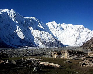
Manaslu is the eighth-highest mountain in the world at 8,163 metres (26,781 ft) above sea level. It is in the Mansiri Himal, part of the Nepalese Himalayas, in the west-central part of Nepal. The name Manaslu means "mountain of the spirit" and is derived from the Sanskrit word manasa, meaning "intellect" or "soul". Manaslu was first climbed on May 9, 1956, by Toshio Imanishi and Gyalzen Norbu, members of a Japanese expedition. It is said that, given the many unsuccessful attempts by the British to climb Everest before New Zealander Edmund Hillary, "just as the British consider Everest their mountain, Manaslu has always been a Japanese mountain".

Gasherbrum II ; surveyed as K4, is the 13th highest mountain in the world at 8,035 metres (26,362 ft) above sea level. It is the third-highest peak of the Gasherbrum massif, and is located in the Karakoram, on the border between Gilgit–Baltistan, Pakistan and Xinjiang, China. The mountain was first climbed on July 7, 1956, by an Austrian expedition which included Fritz Moravec, Josef Larch, and Hans Willenpart.
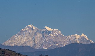
Gaurishankar is a mountain in the Nepal Himalayas, the second highest peak of the Rolwaling Himal, behind Melungtse (7,181m). The name comes from the Hindu goddess Gauri, a manifestation of Parvati, and her consort Shankar, denoting the sacred regard to which it is afforded it by the people of Nepal. The Sherpas name the mountain as Jomo Tseringma. The Nepal Standard Time (GMT+05:45) is based on the meridian of this mountain peak.

Melungtse is the highest mountain of the Rolwaling Himal in the Himalayas.

Kamet is the second highest mountain in the Garhwal region of Uttarakhand, India, after Nanda Devi. It lies in the Chamoli District of Uttarakhand. Its appearance resembles a giant pyramid topped by a flat summit area with two peaks.
An unclimbed mountain is a mountain peak that has yet to be climbed to the top. Determining which unclimbed peak is highest is often a matter of controversy. In some parts of the world, surveying and mapping are still unreliable. There are no comprehensive records of the routes of explorers, mountaineers, and local inhabitants. In some cases, even modern ascents by larger parties have been poorly documented and, with no universally recognized listing, the best that can be achieved in determining the world's highest unclimbed peaks is somewhat speculative. Most sources indicate that Gangkhar Puensum on the Bhutan–China border is the tallest mountain in the world that has yet to be fully summited. Gangkhar Puensum has been off limits to climbers since 1994 when Bhutan prohibited all mountaineering above 6,000 m (20,000 ft) due to spiritual/religious beliefs.
The Buni Zom group is a prominent mountain area of Chitral, in the Hindu Raj range of Pakistan. Buni Zom (main) is the highest peak of the group with an elevation of 6,542 m (21,463 ft). It is located about 50 km (30 mi) northeast of the town of Chitral, and about 50 km (30 mi) east of Tirich Mir, the highest peak in the Hindu Kush.

Himalchuli is the second-highest mountain in the Mansiri Himal, part of the Nepalese Himalayas, and the 18th-highest mountain in the world. It lies south of Manaslu, one of the eight-thousanders. Himalchuli has three main peaks: East, West and North.
Ngadi Chuli is a high mountain summit in the Mansiri Himal, also known as the Gurkha Massif, in Nepal. It is flanked by Manaslu to the north and Himalchuli to the south. With an elevation of 7,871 metres (25,823 ft) above sea level, it is the 20th-highest mountain on Earth.
Rimo I is the main summit of the Rimo massif with an elevation of 7,385 metres (24,229 ft).
Jongsong Peak is a mountain in the Janak section of the Himalayas. At 7,462 metres (24,482 ft) it is the 57th highest peak in the world, although it is dominated by 3rd highest, Kangchenjunga, 20 km (12 mi) to the south. Jongsong's summit is on tripoint of India, Nepal and China.
Nyegyi Kangtsang is a mountain of the Eastern Himalayas located in East Kameng district of Arunachal Pradesh state of India on the border with Tibet.

Kirat Chuli or Tent Peak is a mountain in the Himalayas. It lies on the border between Nepal and India.
Pangpoche, also known as Panpoche I is a mountain in the Himalayas of Nepal. It has a summit elevation of 6,620 metres (21,720 ft) above sea level and is located approximately 15 kilometres (9.3 mi) northeast of the world's eighth-highest mountain, Manaslu. On the ridge of Pangpoche to the South in 1.5 kilometers is located Pangpoche II 6,504 meters.

Lhotse Middle, is a subsidiary peak of 8,410 metres (27,590 ft) in elevation that sits in the middle of a ridge between its parent peak, the eight-thousander, Lhotse 8,516 metres (27,940 ft), and another subsidiary peak, Lhotse Shar 8,383 metres (27,503 ft). In 2013, a proposal by Nepal to the International Climbing and Mountaineering Federation (UIAA) to have Lhotse Middle designated as standalone eight-thousanders was not successful due a perceived lack of topographic prominence. Right beside the peak is the smaller subsidiary peak of Lhotse Central II (8,372 metres ; sometimes the term West tower and East tower are used to distinguish Lhotse Central I and Lhotse Central II, respectively.
Pathibara is a mountain peak located on the border of Nepal and North Sikkim, India.


