
The Himalayas, or Himalaya, are a mountain range in Asia, separating the plains of the Indian subcontinent from the Tibetan Plateau. The range has some of the planet's highest peaks, including the very highest, Mount Everest. Over 100 peaks exceeding 7,200 m (23,600 ft) in elevation lie in the Himalayas. By contrast, the highest peak outside Asia is 6,961 m (22,838 ft) tall.

The Yeti is an ape-like creature purported to inhabit the Himalayan mountain range in Asia. In western popular culture, the creature is commonly referred to as the Abominable Snowman. Many dubious articles have been offered in an attempt to prove the existence of the Yeti, including anecdotal visual sightings, disputed video recordings, photographs, and plaster casts of large footprints. Some of these are speculated or known to be hoaxes.

The Kingdom of Bhutan is a sovereign nation, located towards the eastern extreme of the Himalayas mountain range. It is fairly evenly sandwiched between the sovereign territory of two nations: first, the People's Republic of China on the north and northwest. There are approximately 477 kilometres of border with that nation's Tibet Autonomous Region. The second nation is the Republic of India on the south, southwest, and east; there are approximately 659 kilometres with the states of Arunachal Pradesh, Assam, West Bengal, and Sikkim, in clockwise order from the kingdom. Bhutan's total borders amount to 1,139 kilometres. The Republic of Nepal to the west, the India to the south, and the Union of Myanmar to the southeast are other close neighbours; the former two are separated by only very small stretches of Indian territory.

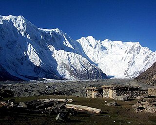
Manaslu is the eighth-highest mountain in the world at 8,163 metres (26,781 ft) above sea level. It is in the Mansiri Himal, part of the Nepalese Himalayas, in the west-central part of Nepal. The name Manaslu means "mountain of the spirit" and is derived from the Sanskrit word manasa, meaning "intellect" or "soul". Manaslu was first climbed on May 9, 1956, by Toshio Imanishi and Gyalzen Norbu, members of a Japanese expedition. It is said that, given the many unsuccessful attempts by the British to climb Everest before New Zealander Edmund Hillary, "just as the British consider Everest their mountain, Manaslu has always been a Japanese mountain".
An unclimbed mountain is a mountain peak that has yet to be climbed to the top. Determining which unclimbed peak is highest is often a matter of controversy. In some parts of the world, surveying and mapping are still unreliable. There are no comprehensive records of the routes of explorers, mountaineers, and local inhabitants. In some cases, even modern ascents by larger parties have been poorly documented and, with no universally recognized listing, the best that can be achieved in determining the world's highest unclimbed peaks is somewhat speculative. Most sources indicate that Gangkhar Puensum in Bhutan or on the Bhutan–China border is the tallest mountain in the world that has yet to be fully summited. Gangkhar Puensum has been off limits to climbers since 1994 when Bhutan prohibited all mountaineering above 6,000 m (20,000 ft) due to spiritual/religious beliefs.

Kula Kangri is claimed by many authorities to be the highest mountain in Bhutan but this is disputed by others, who claim that Kula Kangri is wholly in Tibet. The first ascent was by a combined Japanese and Chinese team in 1986. The mountain occupies two ranges, the Himalaya and the Bhutan Himalaya.
Ben Clark of Clarksville, Tennessee, is a mountaineer and commercial filmmaker. Clark is married to Mary Anne Potts and has a son, Charlie Clark and a daughter, Scarlett Clark. Most of his family members live in Clarksville, Tennessee including his mother and father, Anne and Jerry Clark, Jonathan Clark, his brother, and his two nieces Maggie and Molly Clark. Ben started rock climbing in his late teens and progressed to larger, more challenging mountains in his early 20s, eventually spending a decade pioneering alpine and ski mountaineering routes in the Nepali and Tibetan Himalayas. On May 22, 2003, at the age of 23, Ben became the second-youngest American to summit Mount Everest, via the North-Northeast Ridge Route, and also launched a film career.

Singalila National Park is a National park of India located on the Singalila Ridge at an altitude of more than 7000 feet above sea level, in the Darjeeling district of West Bengal. It is well known for the trekking route to Sandakphu that runs through it.

Hemis National Park is a high-altitude national park in Ladakh, India. Globally famous for its snow leopards, it is believed to have the highest density of them in any protected area in the world. It is the only national park in India that is north of the Himalayas, the largest notified protected area in India and is the second largest contiguous protected area, after the Nanda Devi Biosphere Reserve and surrounding protected areas. The park is home to a number of species of endangered mammals, including the snow leopard. Hemis National Park is India's protected area inside the Palearctic realm, outside the Changthang Wildlife Sanctuary northeast of Hemis, and the proposed Tso Lhamo Cold Desert Conservation Area in North Sikkim.

The snow leopard, also known as the ounce, is a felid in the genus Panthera native to the mountain ranges of Central and South Asia. It is listed as Vulnerable on the IUCN Red List because the global population is estimated to number fewer than 10,000 mature individuals and is expected to decline about 10% by 2040. It is threatened by poaching and habitat destruction following infrastructural developments. It inhabits alpine and subalpine zones at elevations of 3,000–4,500 m (9,800–14,800 ft), ranging from eastern Afghanistan, the Himalayas and the Tibetan Plateau to southern Siberia, Mongolia and western China. In the northern part of its range, it also lives at lower elevations.

Chopta is a small region of meadows and evergreen forest area, a part of Kedarnath wildlife sanctuary located in Uttarakhand state, India and a base for trekking to Tungnath, the third temple of Panch Kedar which lies 3.5 kilometres (2.2 mi) away. Located at a distance of 1.5 kilometres (0.93 mi) from Tungnath is Chandrashila, a summit rising to over 4,000 metres (13,000 ft).
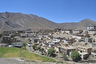
Kibber, also Kibber Khas and Khyipur, is a village high in the Spiti Valley in the Himalayas at 4,270 m (14,010 ft) in Himachal Pradesh in northern India. It contains a monastery and is a base for visiting the Kibber Wildlife Sanctuary. It is located 19 km (12 mi) from Kaza and a bus service connects them in the summer months. Agriculture forms the backbone of the local economy and lush green fields are abundant. It is the base for visitors to the Kibber Wildlife Sanctuary, home to about 30 snow leopards. Treks to neaby peaks and to a high pass in the Zanskar range between Spiti and Ladakh start from Kibber.
The Phobjikha Valleyཕོབ་སྦྱིས་ཁ spelled as Pho-sbis-kha, is a vast U-shaped valley in central Bhutan. The valley houses one of the impressive ancient Buddhist monasteries in Bhutan known as Gangteng Monastery of the Nyingma sect in central Bhutan. The graceful black-necked cranes in Bhutan from the Tibetan Plateau visit the valley during the winter season to roost. On arrival in the Phobjikha Valley in the last week of October, the black-necked cranes circle the Gangteng Monastery three times and also repeat the process while returning to Tibet.

The Great Himalaya Trail is a route across the Himalayas from east to west. The original concept of the trail was to establish a single long distance trekking trail from the east end to the west end of Nepal that includes a total of roughly 1,700 kilometres (1,100 mi) of path. There is a proposed trail of more than 4,500 kilometres (2,800 mi) stretching the length of the Greater Himalaya range from Nanga Parbat in Pakistan to Namche Barwa in Tibet thus passing through, India, Nepal, Bhutan and Tibet. Although an actual continuous route is currently only a concept, if completed it would be the longest and highest alpine hiking track in the world.
Lost Land of the Tiger is a three-part nature documentary series produced by the BBC Natural History Unit which follows a scientific expedition to the Himalayan kingdom of Bhutan. The expedition team is made up of specialist zoologists, explorers and the BBC crew. Together, they explore wilderness areas from the lowland jungles to high-altitude slopes, in search of rare animals and plants. The focus of the expedition is to investigate the status of the tiger in Bhutan, where little is known of the cat's distribution or population density. Evidence of a healthy population of tigers would elevate Bhutan's importance as a sanctuary for this endangered species. It would also support tiger conservationist Dr. Alan Rabinowitz's proposal for a vast protected corridor linking the fragmented pockets of tiger habitat which lie to the south of the Himalayas.

Jigme Singye Wangchuck National Park covers an area of 1,730 square kilometres (670 sq mi) in central Bhutan. It protects a large area of the Black Mountains, a sub−range of the Himalayan Range System.

Wangchuck Centennial National Park in northern Bhutan is the kingdom's largest national park, spanning 4,914 square kilometres (1,897 sq mi) over five districts, occupying significant portions of northern Bumthang, Lhuntse, and Wangdue Phodrang Districts. It borders Tibet to the north and is bound by tributaries of the Wong Chhu (Raidāk) basin to the west. Wangchuck Centennial directly abuts Jigme Dorji National Park, Bumdeling Wildlife Sanctuary, and Phrumsengla National Park in northern Bhutan, and is further connected to Jigme Singye Wangchuck National Park in central Bhutan via biological corridors. Thus, most of northern Bhutan is part of these protected areas.

The Annapurna Circuit is a trek within the mountain ranges of central Nepal. The total length of the route varies between 160–230 km (100-145 mi), depending on where motor transportation is used and where the trek is ended. This trek crosses two different river valleys and encircles the Annapurna Massif. The path reaches its highest point at Thorung La pass (5416m/17769 ft), reaching the edge of the Tibetan plateau. Most trekkers hike the route anticlockwise, as this way the daily altitude gain is slower, and crossing the high Thorong La pass is easier and safer.
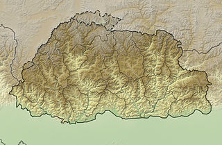
The mountains of Bhutan are some of the most prominent natural geographic features of the kingdom. Located on the southern end of the Eastern Himalaya, Bhutan has one of the most rugged mountain terrains in the world, whose elevations range from 160 metres (520 ft) to more than 7,000 metres (23,000 ft) above sea level, in some cases within distances of less than 100 kilometres (62 mi) of each other. Bhutan's highest peak, at 7,570 metres (24,840 ft) above sea level, is north-central Gangkhar Puensum, close to the border with Tibet; the third highest peak, Jomolhari, overlooking the Chumbi Valley in the west, is 7,314 metres (23,996 ft) above sea level; nineteen other peaks exceed 7,000 metres (23,000 ft). Weather is extreme in the mountains: the high peaks have perpetual snow, and the lesser mountains and hewn gorges have high winds all year round, making them barren brown wind tunnels in summer, and frozen wastelands in winter. The blizzards generated in the north each winter often drift southward into the central highlands.

The Dochu La( Dochu Pass, la means pass in Dzongkha) is a mountain pass in the snow covered Himalayas within Bhutan on the road from Thimphu to Punakha where 108 memorial chortens or stupas known as "Druk Wangyal Chortens" have been built by Ashi Dorji Wangmo Wangchuk, the eldest Queen Mother. Apart from the chortens there is a monastery called the Druk Wangyal Lhakhang (temple), built in honour of the fourth Druk Gyalpo, Jigme Singye Wangchuck; the open grounds in its front yard is a venue for the annual Dochula Druk Wangyel Festival. The pass with 108 memorial chortens is adjacent to the country's first Royal Botanical Park.
