
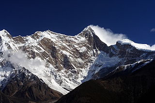
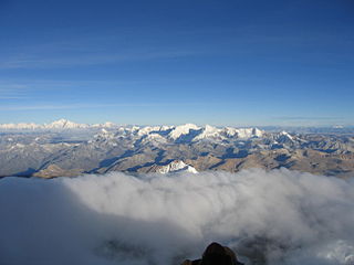
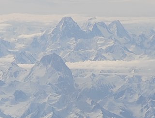
The Himalayas, or Himalaya, is a mountain range in Asia, separating the plains of the Indian subcontinent from the Tibetan Plateau. The range has some of the Earth's highest peaks, including the very highest, Mount Everest; over 100 peaks exceeding elevations of 7,200 m (23,600 ft) above sea level lie in the Himalayas.

Melungtse is the highest mountain of the Rolwaling Himal in the Himalayas.

Kula Kangri is claimed by many authorities to be the highest mountain in Bhutan but this is disputed by others, who claim that Kula Kangri is wholly in Tibet.The mountain is part of the Bhutan Himalaya.
Namcha Barwa or Namchabarwa is a mountain peak lying in Tibet in the region of Pemako. The traditional definition of the Himalaya extending from the Indus River to the Brahmaputra would make it the eastern anchor of the entire mountain chain, and it is the highest peak of its own section as well as Earth's easternmost peak over 7,600 metres (24,900 ft). It lies in the Nyingchi Prefecture of Tibet. It is the highest peak in the 180 km long Namcha Barwa Himal range, which is considered the easternmost syntaxis/section of the Himalaya in southeastern Tibet and northeastern India where the Himalaya are said to end, although high ranges actually continue another 300 km to the east.
Labuche Kang is a northern outlier of the Himalayas inside Tibet. It rises northwest of Rolwaling Himal and east of Shishapangma. The peak belongs to a little-known section of the Himalaya variously called Labuche Himal, Pamari Himal and Lapchi Kang. that extends from the valley of the Tamakosi River west to the valley of the Sun Kosi and Nyalam Tong La pass where Arniko-Friendship Highway cross the Himalaya. This section extends south into Nepal east of Arniko Highway. It is wholly within the catchment of the Kosi, a Ganges tributary.

Mount Nyenchen Tanglha is the highest peak of Nyenchen Tanglha Mountains, which together with the Gangdise range forms the Transhimalaya.

The Hengduan Mountains are a group of mountain ranges in southwest China that connect the southeast portions of the Tibetan Plateau with the Yunnan–Guizhou Plateau. The Hengduan Mountains are primarily large north-south mountain ranges that effectively separate lowlands in northern Myanmar from the lowlands of the Sichuan Basin. These ranges are characterized by significant vertical relief originating from the Indian subcontinent's collision with the Eurasian Plate, and further carved out by the major rivers draining the eastern Tibetan Plateau. These rivers, the Yangtze, Mekong, and Salween, are recognized today as the Three Parallel Rivers UNESCO World Heritage Site.

An ultra-prominent peak, or Ultra for short, is a mountain summit with a topographic prominence of 1,500 metres (4,900 ft) or more; it is also called a P1500. The prominence of a peak is the minimum height of climb to the summit on any route from a higher peak, or from sea level if there is no higher peak. There are approximately 1,524 such peaks on Earth. Some well-known peaks, such as the Matterhorn and Eiger, are not Ultras because they are connected to higher mountains by high cols and therefore do not achieve enough topographic prominence.
Tongshanjiabu is a mountain in the Himalayas.

Nemjung is a mountain in the Himalayas of Nepal. It is located approximately 150 kilometres (93 mi) northwest of the Nepalese capital Kathmandu and about 25 km northwest of the eight-thousander, Manaslu. Its summit has an elevation of 7,140 metres (23,425 ft).
Pauhunri is a mountain in the Eastern Himalayas. It is located on the border of Sikkim, India and Tibet and is situated about 75 km northeast of Kangchenjunga. It marks the origin of Teesta river.

Kangto at 7,090 metres (23,261 ft) is a mountain of the Eastern Himalayas located in the Indian state of Arunachal Pradesh and it shares its border with the Tibet Autonomous Region of China. It is the highest point in Arunachal Pradesh. The area in which Kangto is located lies in the Lada circle of East Kameng district of the state. On the Chinese side, it lies in Cona County of Shannan Prefecture, Tibet.
The Crown, also known as Huang Guan Shan and sometimes Crown Peak, is a mountain in the Karakoram mountain range in China. It is located in the Xinjiang Uyghur Autonomous Region of China. About 42 kilometers from Chogori Peak. Its summit has an elevation of 7,295 metres (23,934 ft) and it is the highest peak in the Yengisogat subrange of the Karakoram.
Kezhen Peak, also known as Karpogo Sar, is a mountain in the Karakoram mountain range. It is located in the Xinjiang Autonomous Region of China.
Liushi Shan, also known as Kunlun Goddess Peak, is a mountain in the Kunlun Mountain Range in China. The mountain is located on the border of the Tibet and Xinjiang autonomous regions of China.
Lunpo Gangri, also known as Loinbo Kangri, is a Himalayan mountain in Tibet Autonomous Region, China. It has an elevation of 7,095 metres (23,278 ft) and is the highest peak in the Gangdise range.

Kanjiroba is a mountain in the Himalayas of Dolpa District in Nepal.
Jethi Bahurani is mountain in the Himalayas of Nepal. Located in Darchula District, it has a summit elevation of 6,850 meters above sea level.
Kubi Gangri is a mountain in the Himalayas of Asia. It has a summit elevation of 6,859 meters above sea level and is located on the international border between Nepal and Tibet, China.
Changla is a mountain in the Himalayas of Asia. It has a summit elevation of 6,721 metres (22,051 ft) above sea level and is located on the international border between Nepal and Tibet, China.

