List of Ultras of the Himalayas

Last updated

This is a list of all the Ultra prominent peaks (with topographic prominence greater than 1,500 metres) in the Himalayas. Listed separately, to the west and north-west are the Karakoram and Hindu Kush Ultras, and while to the north-east and east are the ultras of Tibet.

Contents

9 of the 10 Himalayan 8,000m peaks are ultras (the exception is Lhotse), and there are a further 28 peaks over 7000m.

Kashmir/Punjab - Between Indus and Sutlej Rivers

Nanga Parbat, Pakistan Northern Areas 38b commons.jpg
Nanga Parbat, Pakistan
Manirang, India Manirang.jpg
Manirang, India
NoPeakCountryElevation (m)Prominence (m)Col (m)
1 Nanga Parbat Flag of Pakistan.svg  Pakistan 8,1254,6083517
2 Nun Flag of India.svg  India 7,1352,4044731
3 Shikar Beh Flag of India.svg  India 6,2002,2233977
4 Parbati Parbat Flag of India.svg  India 6,6332,0934540
5 Reo Purgyil Flag of India.svg  India  / Flag of the People's Republic of China.svg  China 6,8161,9784838
6 Sunset Peak Flag of India.svg  India 4,7451,9422803
7 Miranjani Flag of Pakistan.svg  Pakistan 2,9811,9111070
8 Gya Flag of India.svg  India  / Flag of the People's Republic of China.svg  China 6,7941,9104884
9 Dofana Flag of Pakistan.svg  Pakistan 5,9401,8754065
10 Point 5608 Flag of Pakistan.svg  Pakistan  / Flag of India.svg  India 5,6081,8503758
11 Manirang Flag of India.svg  India 6,5931,7274866
12 Point 5800 Flag of Pakistan.svg  Pakistan 5,8001,6824118
13 Point 6086 Flag of India.svg  India 6,0861,6184468
14 Bharanzar Flag of India.svg  India 6,5741,6064968
15 Mulkila Flag of India.svg  India 6,5171,5864931
16 Kolahoi Flag of India.svg  India 5,4251,5853840
17 Point 5971 Flag of India.svg  India 5,9711,5664405
18 Junkor Flag of Pakistan.svg  Pakistan  / Flag of India.svg  India 5,3731,5633810
19 Doda Flag of India.svg  India 6,5731,5045069

Garhwal&Kumaon [1] - Sutlej to Kali Rivers

Nanda Devi, India Nanda devi.jpg
Nanda Devi, India
NoPeakCountryElevation (m)Prominence (m)Col (m)
1 Nanda Devi Flag of India.svg  India 7,8163,1394677
2 Kamet Flag of India.svg  India 7,7562,8254931
3 Rangrik Rang Flag of India.svg  India 6,6841,6745010
4 Haathi Parvat Flag of India.svg  India 6,7271,6735054
5 Trisul Flag of India.svg  India 7,1201,6165504
6 Panchchuli Flag of India.svg  India 6,9041,6145290
7 Chaukhamba Flag of India.svg  India 7,1381,5945544
8 Nanda Kot Flag of India.svg  India 6,8611,5925269

Western Nepal/Tibet: Sharda River to Kali Gandaki River

NoPeakCountryElevation (m)Prominence (m)Col (m)
1 Dhaulagiri Flag of Nepal.svg    Nepal 8,1673,3574810
2 Gurla Mandhata Flag of the People's Republic of China.svg  China 7,6942,7884906
3 Dhaulagiri II Flag of Nepal.svg    Nepal 7,7522,3975355
4 Api Flag of Nepal.svg    Nepal 7,1322,0405092
5 Kanjiroba Flag of Nepal.svg    Nepal 6,8831,8705013
6 Saipal Flag of Nepal.svg    Nepal 7,0311,8245207
7 Kubi Gangri Flag of Nepal.svg    Nepal  / Flag of the People's Republic of China.svg  China 6,8591,6995160
8 Deora Flag of Nepal.svg    Nepal 4,3901,6782712
9 Changla Flag of Nepal.svg    Nepal  / Flag of the People's Republic of China.svg  China 6,7211,6575064
10 Bhalu Lek Flag of Nepal.svg    Nepal 5,4251,6433782
11 Jethi Bahurani Flag of Nepal.svg    Nepal 6,8501,5585292

The Kali Gandaki River is normally considered to mark the divide between the Western and Eastern Himalayas.

Central Nepal/Tibet: Kali Gandaki River to Arun River

Mount Everest, Nepal/China Mount Everest North Face.jpg
Mount Everest, Nepal/China
Annapurna, Nepal Annapurna from west.jpg
Annapurna, Nepal
Makalu, Nepal/China Makalu.jpg
Makalu, Nepal/China
Manaslu, Nepal Sunrise, Manaslu.jpg
Manaslu, Nepal
NoPeakCountryElevation (m)Prominence (m)Col (m)
1 Mount Everest Flag of the People's Republic of China.svg  China  / Flag of Nepal.svg    Nepal 8,8488,8480
2 Manaslu Flag of Nepal.svg    Nepal 8,1633,0925071
3 Annapurna I Flag of Nepal.svg    Nepal 8,0912,9845107
4 Shishapangma Flag of the People's Republic of China.svg  China 8,0272,8975130
5 Annapurna II Flag of Nepal.svg    Nepal 7,9372,4375500
6 Makalu Flag of the People's Republic of China.svg  China  / Flag of Nepal.svg    Nepal 8,4852,3786107
7 Yangra Flag of Nepal.svg    Nepal  / Flag of the People's Republic of China.svg  China 7,4222,3525070
8 Cho Oyu Flag of the People's Republic of China.svg  China  / Flag of Nepal.svg    Nepal 8,1882,3405848
9 Chamar Flag of Nepal.svg    Nepal 7,1652,0615104
10 Labuche Kang Flag of the People's Republic of China.svg  China 7,3671,9575410
11 Nemjung Flag of Nepal.svg    Nepal 7,1401,9205220
12Tsanglha Ri (Zang La)Flag of the People's Republic of China.svg  China 6,4951,7124783
13 Himalchuli Flag of Nepal.svg    Nepal 7,8931,6336260
14 Pangpoche Flag of Nepal.svg    Nepal 6,6201,6224998
15 Gauri Sankar Flag of Nepal.svg    Nepal  / Flag of the People's Republic of China.svg  China 7,1461,6005546
16 Melungtse {{ CHN}}7,1811,5515630
17 Langtang Lirung Flag of Nepal.svg    Nepal 7,2341,5345700

Arun River to Bhutan border

Kangchenjunga, Nepal/India Kangch-Goechala.jpg
Kangchenjunga, Nepal/India
NoPeakCountryElevation (m)Prominence (m)Col (m)
1 Kangchenjunga Flag of Nepal.svg    Nepal  / Flag of India.svg  India 8,5863,9224664
2 Pauhunri Flag of India.svg  India  / Flag of the People's Republic of China.svg  China 7,1282,0355093
3 Nyonno Ri Flag of the People's Republic of China.svg  China 6,7241,8054919
4 Pandim Flag of India.svg  India 6,6911,7624929
5 Chomo Yummo Flag of the People's Republic of China.svg  China  / Flag of India.svg  India 6,8291,5595270

Bhutan to the Brahmaputra (Assam Himalaya)

Gangkhar Puensum, Bhutan/China GangkharPuensum3.jpg
Gangkhar Puensum, Bhutan/China
NoPeakCountryElevation (m)Prominence (m)Col (m)
1 Namcha Barwa Flag of the People's Republic of China.svg  China 7,7824,1063676
2 Gangkhar Puensum Flag of Bhutan.svg  Bhutan  / Flag of the People's Republic of China.svg  China 7,5702,9954575
3 Kangto Flag of India.svg  India  / Flag of the People's Republic of China.svg  China 7,0602,1954865
4 Noijin Kangsang Flag of the People's Republic of China.svg  China 7,1912,1455046
5 Chomolhari Flag of Bhutan.svg  Bhutan  / Flag of the People's Republic of China.svg  China 7,3262,0775249
6 Yarla Shampo Flag of the People's Republic of China.svg  China 6,6361,8054831
7 Tongshanjiabu Flag of Bhutan.svg  Bhutan  / Flag of the People's Republic of China.svg  China 7,2071,7575450
8 Nyegyi Kansang Flag of India.svg  India  / Flag of the People's Republic of China.svg  China 7,0471,7525295
9 Point 5980 Flag of India.svg  India  / Flag of the People's Republic of China.svg  China 5,9801,7474233
10 Tarlha Ri Flag of the People's Republic of China.svg  China 6,7771,6975080
11HP Dafla Range Flag of India.svg  India 3,7761,6842092
12 Point 5641 Flag of India.svg  India  / Flag of the People's Republic of China.svg  China 5,6411,6813960
13 Kula Kangri Flag of Bhutan.svg  Bhutan  / Flag of the People's Republic of China.svg  China 7,5531,6695884
14 Tarka La Flag of Bhutan.svg  Bhutan 4,7351,6243111
15 Kazi Razi Flag of the People's Republic of China.svg  China 6,5051,5614944
16 Point 6215 Flag of the People's Republic of China.svg  China 6,2151,5214694
16 Point 5840 Flag of the People's Republic of China.svg  China 58401,5114329

Related Research Articles

Geography of India Geography of the country of India

India is situated north of the equator between 8°4' north to 37°6' north latitude and 68°7' east to 97°25' east longitude. It is the seventh-largest country in the world, with a total area of 3,287,263 square kilometres (1,269,219 sq mi). India measures 3,214 km (1,997 mi) from north to south and 2,933 km (1,822 mi) from east to west. It has a land frontier of 15,200 km (9,445 mi) and a coastline of 7,516.6 km (4,671 mi).

Geography of China Geographical features of China

China is a country located in East Asia with an area of 9,596,960 km2 (3,705,410 sq mi). The exact land area can sometimes be challenged by border disputes, including those concerning Taiwan, Aksai Chin, the Trans-Karakoram Tract, the South China Sea Islands, the Senkaku Islands, and South Tibet. As sovereignty over Hong Kong and Macau were restored to China in 1997 and 1999, two special administrative regions were established under the One Country, Two Systems policy. The People's Republic of China is either the third or fourth largest country in the world, being either slightly larger or slightly smaller than the United States depending on how the area of the United States is measured.

Himalayas Mountain range in Asia

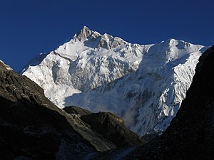
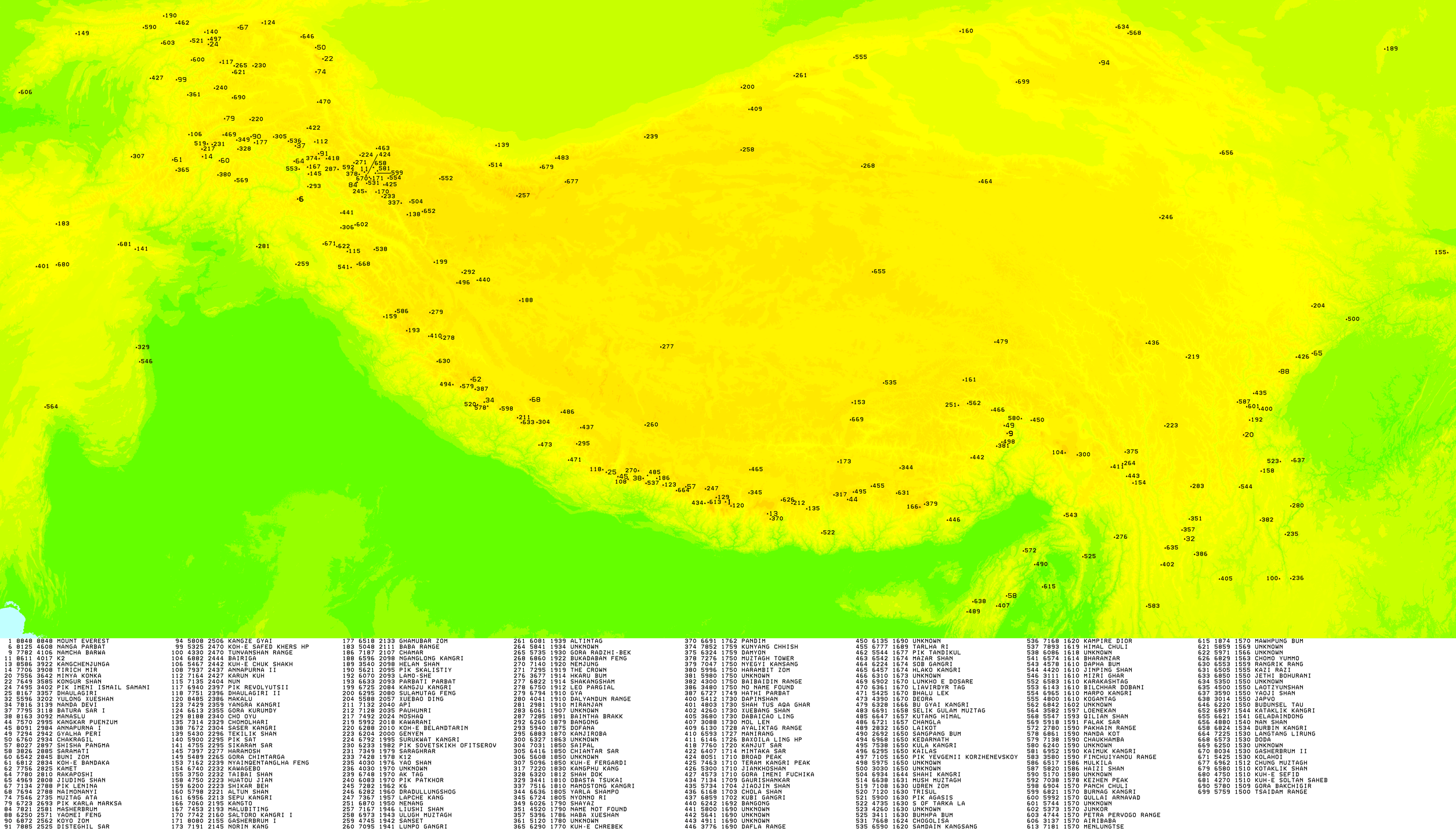
The Himalayas, or Himalaya, are a mountain range in Asia separating the plains of the Indian subcontinent from the Tibetan Plateau. The range has some of the planet's highest peaks, including the highest, Mount Everest. Over 100 peaks exceeding 7,200 m (23,600 ft) in elevation lie in the Himalayas. By contrast, the highest peak outside Asia is 6,961 m (22,838 ft) tall.

Saser Kangri Mountain in India

Saser Kangri is a mountain in India. It is the highest peak in the Saser Muztagh, the easternmost subrange of the Karakoram range. Sasir Kangri is located within Ladakh, the northernmost union territory in India.

Melungtse

Melungtse is the highest mountain of the Rolwaling Himal in the Himalayas.

K12 is the second highest peak in the Saltoro Mountains, a subrange of the Karakoram range in the Siachen region, in Ladakh, India. Its name comes from its designation given during the original survey of the Karakoram range. In 1984, an Indian army expedition under Colonel Prem Chand took hold of this peak, from the side of Siachen glacier by traversing from the west.

Blanca Peak Mountain in Colorado, United States

Blanca Peak is the fourth highest summit of the Rocky Mountains of North America and the U.S. state of Colorado. The ultra-prominent 14,351-foot (4,374 m) peak is the highest summit of the Sierra Blanca Massif, the Sangre de Cristo Range, and the Sangre de Cristo Mountains. The fourteener is located 9.6 miles (15.5 km) north by east of the Town of Blanca, on the drainage divide separating Rio Grande National Forest and Alamosa County from the Sangre de Cristo Land Grant and Costilla County. The summit is the highest point of both counties and the entire drainage basin of the Rio Grande. Below the steep North Face of Blanca Peak two live Glaciers once developed, until extinction sometime after 1903. North & South Blanca Glaciers were located at 37° 35N.,longitude 105° 28W. Blanca Peak is higher than any point in the United States east of its longitude.

Cloud Peak Mountain in Wyoming, United States

Cloud Peak is the highest peak within the Bighorn Mountains in the U.S. state of Wyoming. It rises to an elevation of 13,171 feet (4,015 m) and provides onlookers with dramatic views and vistas. The mountain can be climbed most easily from the western side, accessed by either the Battle Park or West Tensleep trail-heads and is roughly 24 miles round-trip from both. The peak is located in the 189,000 acre (765 km²) Cloud Peak Wilderness within Bighorn National Forest. The northeast slope of Cloud Peak is a deep cirque which harbors Cloud Peak Glacier, the last active glacier in the Bighorn Mountains.

Patkai

The Pat-kai (Pron:pʌtˌkaɪ) or Patkai Bum are a series of mountains in the Indo-Myanmar border falling in the north-eastern Indian states of Arunachal Pradesh, Nagaland and Upper Burma region of Myanmar. They were created by the same tectonic processes that created the Himalayas in the Mesozoic. In Tai-Ahom language, Pat means to cut and Kai means chicken.

Geography of West Bengal Overview of the geography of the Indian state

Geography of West Bengal, a state in eastern India, is diverse, of high peaks of Himalaya in the northern extremes to where Himalayas are in the north and sea is at the south, with both plains and plateaus covering the remaining region.

Darjeeling Himalayan hill region or Darjeeling Himalaya is the mountainous area on the north-western side of the state of West Bengal in India. This region belongs to the Eastern Himalaya range. The Darjeeling district except the Siliguri subdivision and the entire Kalimpong district constitute this region. It arises abruptly from the Terai region. The region slopes from a south to north direction. The river Teesta divides the region in two parts — the region to the east of Teesta and the region to the west of Teesta.

Geography of Himachal Pradesh

The state of Himachal Pradesh is spread over an area 55,673 km2 (21,495 sq mi) and is bordered by Jammu and Kashmir and Ladakh on the north, Punjab on the southwest, Haryana on the south, Uttarakhand on the southeast, a small border with Uttar Pradesh in the south, and Tibet on the east. Entire Himachal Pradesh lies in the mountainous Himalaya region, rich in natural resources

Geography of Ladakh Aspect of geography

The geographical region of Ladakh union territory is the highest altitude plateau region in India, incorporating parts of the Himalayan and Karakoram mountain ranges and the upper Indus River valley.

Ultra-prominent peak Mountain summit with a topographic prominence of 1,500 metres (4,900 ft) or more

An ultra-prominent peak, or Ultra for short, is a mountain summit with a topographic prominence of 1,500 metres (4,900 ft) or more; it is also called a P1500. The prominence of a peak is the minimum height of climb to the summit on any route from a higher peak, or from sea level if there is no higher peak. There are approximately 1,524 such peaks on Earth. Some well-known peaks, such as the Matterhorn and Eiger, are not Ultras because they are connected to higher mountains by high cols and therefore do not achieve enough topographic prominence.

Saipal is a mountain in the Himalayas of north-west Bajhang district in Nepal.

Shan Hills Mountainous zone in Yunnan, Myanmar and Thailand

The Shan Hills, also known as Shan Highland, is a vast mountainous zone that extends through Yunnan to Myanmar and Thailand. The whole region is made up of numerous mountain ranges separated mostly by narrow valleys as well as a few broader intermontane basins. The ranges in the area are aligned in such a way that they link to the foothills of the Himalayas further to the northwest.

Noijin Kangsang

Noijin Kangsang is the highest peak of Lhagoi Kangri mountain range in the Tibet Autonomous Region in China. It lies between the Yarlung Tsangpo River, Yamdrok Lake and the Himalayas mountain range.

Lists of mountains can be organized by continent and more specifically by country and province/state:

References

  1. "Kumaun Himalayas | mountains, India".

Sources