
Southeast Asia, also spelled South East Asia and South-East Asia, and also known as Southeastern Asia or SEA, is the geographical southeastern subregion of Asia, consisting of the regions that are south of China, south-east of the Indian subcontinent and north-west of Australia. Southeast Asia is bordered to the north by East Asia, to the west by South Asia and the Bay of Bengal, to the east by Oceania and the Pacific Ocean, and to the south by Australia and the Indian Ocean. Apart from the British Indian Ocean Territory and two out of 26 atolls of Maldives in South Asia, Southeast Asia is the only other subregion of Asia that lies partly within the Southern Hemisphere. The majority of the subregion is still in the Northern Hemisphere. East Timor and the southern portion of Indonesia are the only parts that are south of the Equator.
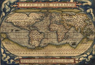
Theatrum Orbis Terrarum is considered to be the first true modern atlas. Written by Abraham Ortelius, strongly encouraged by Gillis Hooftman and originally printed on 20 May 1570 in Antwerp, it consisted of a collection of uniform map sheets and supporting text bound to form a book for which copper printing plates were specifically engraved. The Ortelius atlas is sometimes referred to as the summary of sixteenth-century cartography. The publication of the Theatrum Orbis Terrarum (1570) is often considered as the official beginning of the Golden Age of Netherlandish cartography.

The Coromandel Coast is the southeastern coastal region of the Indian subcontinent, bounded by the Utkal Plains to the north, the Bay of Bengal to the east, the Kaveri delta to the south, and the Eastern Ghats to the west, extending over an area of about 22,800 square kilometres. The coast has an average elevation of 80 metres and is backed by the Eastern Ghats, a chain of low lying and flat-topped hills.

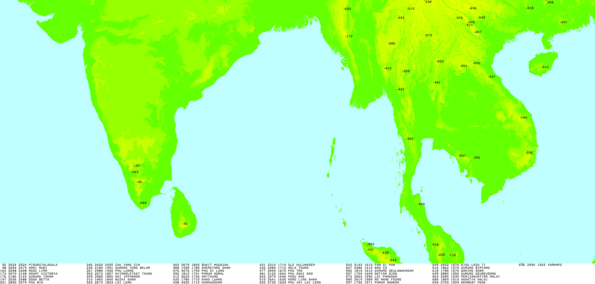
Mount Kerinci is an active stratovolcano and the highest mountain in Sumatra, Indonesia. At 12,484 ft (3,805 m) above sea level, it provides Sumatra with the fifth-highest maximum elevation of any island in the world. It is surrounded by the lush forest of Kerinci Seblat National Park, home to several endangered species including the Sumatran tiger and Sumatran rhinoceros.
The Wollemi Creek, a partly perennial stream of the Hawkesbury-Nepean catchment, is located in the Central Tablelands and Blue Mountains regions of New South Wales, Australia.
Gonystylus is a southeast Asian genus of about 30 species of hardwood trees also known as ramin, melawis (Malay) and ramin telur (Sarawak).

The Missisquoi River is a transboundary river of the east shore of Lake Champlain, approximately 80 miles (130 km) long, in northern Vermont in the United States and southern Quebec in Canada.

Fansipan is a mountain in Vietnam. The height of the mountain was 3,143 metres (10,312 ft) in 1909, but now the height of the mountain is 3,147.3 metres (10,326 ft). It is the highest mountain in the Indochinese Peninsula, hence its nickname "the Roof of Indochina". It is located in the Lào Cai Province of the Northwest region of Vietnam, 9 km (5.6 mi) southwest of Sa Pa in the Hoang Lien Son mountain range. Administratively, it is shared between Tam Đường district, Lai Châu and Sa Pa town, Lào Cai.

The Lut Desert, widely referred to as Dasht-e Lut, is a large salt desert located in the provinces of Kerman and Sistan and Baluchestan, Iran. It is the world's 34th-largest desert, and was included on UNESCO's World Heritage List on July 17, 2016. The name is driven from 'Lut' which means bare and empty in Persian and 'dasht' which means plain in Persian. The surface of its sand has been measured at temperatures as high as 70 °C (159 °F), making it one of the world's driest and hottest places.

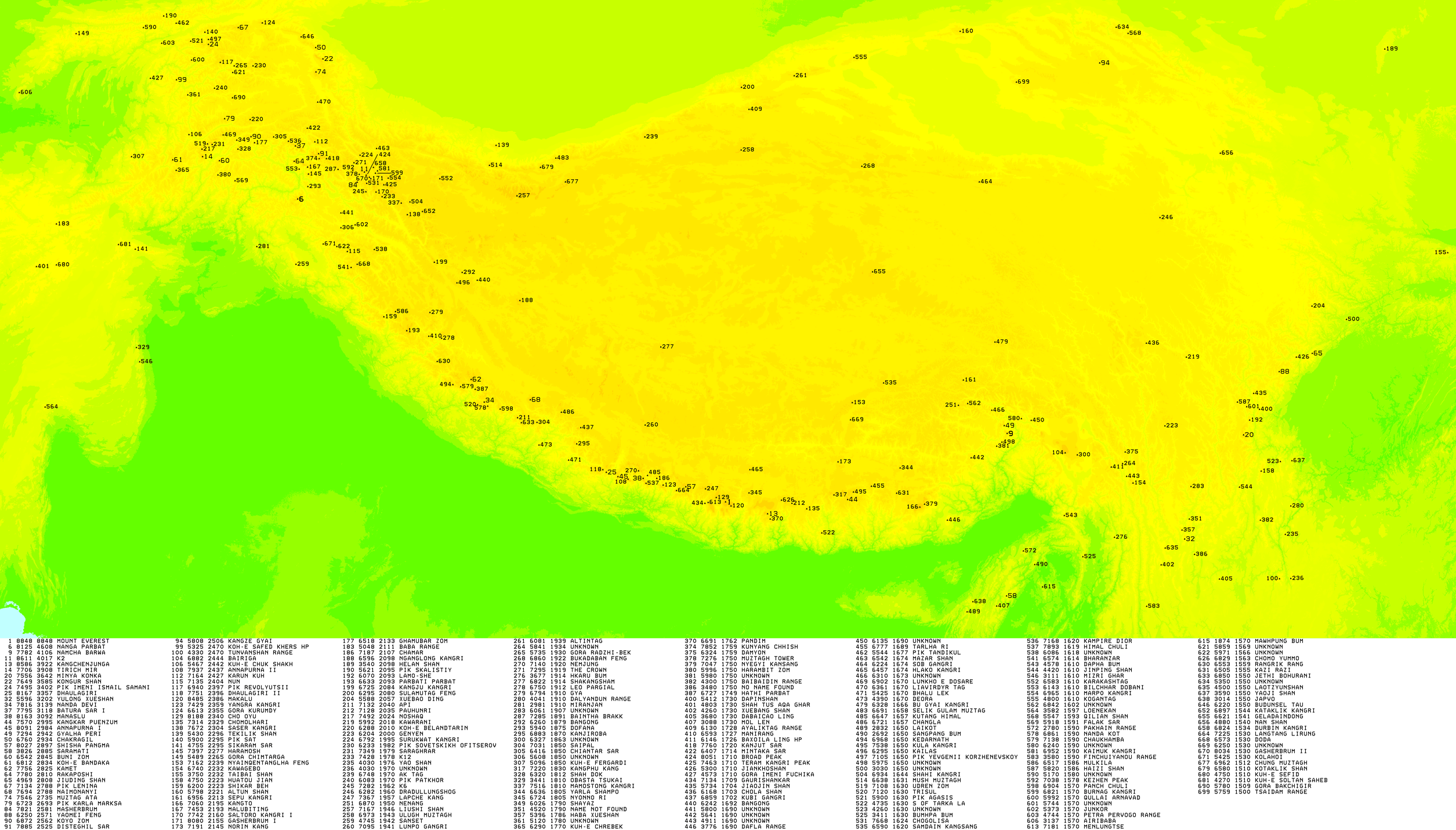
The Saser Muztagh is the easternmost subrange of the Karakoram range, in the Ladakh region of India. It is bounded on the south, east and northeast by the Shyok River, which bends sharply around the southeast corner of the range. On the west it is separated from the neighboring Kailas Mountains by the Nubra River, while the Sasser Pass marks the boundary between this range and the Rimo Muztagh to the north. The Ladakh Range stands to the south of the Saser Muztagh, across the Shyok River.
Radio Veritas Asia is the non-commercial Catholic shortwave station broadcasting to Asia. It is based in Quezon City, Philippines, and is owned by the Philippine Radio Educational and Information Center, which previously owned the original Radio Veritas from 1969 to 1991. Its Urdu Service started its broadcast on August 14, 1987, in Lahore, Pakistan. Its mission is to promote justice to the oppressed through programs with specific moral, religious and inspirational content, and to voice peace and harmony among the sects, races, and sexes through sociocultural programs and to promote dialogue among different religions.
Native Indonesians, also known as Pribumi, are Indonesians whose ancestral roots lie mainly in the archipelago, distinguished from Indonesians of known (partial) foreign descent, like Chinese Indonesians (Tionghoa), Arab Indonesians, Indian Indonesians and Indo-Europeans (Eurasians).

The 1997 Southeast Asian haze was an international air pollution disaster that occurred during the second half of 1997, its after-effects causing widespread atmospheric visibility and health problems within Southeast Asia. Considered the most severe Southeast Asian haze event of all time, the total costs of the 1997 haze are estimated at US$9 billion, due mainly to health care and disruption of air travel and business activities.
Qingyang Xifeng Airport is an airport serving the city of Qingyang in Gansu Province, China.

An ultra-prominent peak, or Ultra for short, is a mountain summit with a topographic prominence of 1,500 metres (4,900 ft) or more; it is also called a P1500. The prominence of a peak is the minimum height of climb to the summit on any route from a higher peak, or from sea level if there is no higher peak. There are approximately 1,524 such peaks on Earth. Some well-known peaks, such as the Matterhorn and Eiger, are not Ultras because they are connected to higher mountains by high cols and therefore do not achieve enough topographic prominence.

The following outline is provided as an overview of and topical guide to Asia.

Mount Alfred is a mountain located at the Queen Reach arm and head of the Jervis Inlet within the Pacific Ranges of the Coast Mountains in British Columbia, Canada. The mountain is the highest in the portion of the mainland between Jervis and Toba Inlets, with its 1,318 metres (4,324 ft) prominence defined by the pass at the head of the Skwawka River, which feeds the head of Jervis Inlet. The unofficially-named Alfred Creek Falls, on Alfred Creek which drains off the mountain's glaciers southeast into the Skwawka, is one of Canada's highest waterfalls at 700 metres (2,297 ft).
Latukan volcano is a potentially active stratovolcano in the centre of a chain of young E-W-trending stratovolcanoes in northwest Mindanao, southeast of Lake Lanao, province of Lanao del Sur, island of Mindanao, in the Bangsamoro Autonomous Region in Muslim Mindanao.

Ohn no khao swè is a Burmese dish consisting of wheat noodles in a curried chicken and coconut milk broth thickened with gram flour. The dish is often garnished with crisp fried bean fritters, sliced raw onions, chillies, crisp noodles, and slices of hard-boiled egg, and zested with lime or lemon juice and fish sauce.

