List of Ultras of Oceania

Last updated

This is a list of the 67 ultra-prominent summits (with topographic prominence greater than 1,500 metres) of Oceania, plus the two Ultras of the Southern Indian Ocean.

Contents

Indonesian New Guinea

There are 12 ultra-prominent summits in Papua, Indonesia.

Rank PeakCountryIslandElevation (m)Prominence (m)Col (m)
1 Puncak Jaya (Carstensz Pyramid) Flag of Indonesia.svg  Indonesia New Guinea 4,8844,8840
2 Pegunungan Arfak Flag of Indonesia.svg  Indonesia New Guinea 2,9552,775179
3 Puncak Mandala Flag of Indonesia.svg  Indonesia New Guinea 4,7602,7602000
4 Mount Kobowre Flag of Indonesia.svg  Indonesia New Guinea 3,7502,2171533
5 Mount Gauttier Flag of Indonesia.svg  Indonesia New Guinea 2,2302,007223
6 Mount Wondiwoi Flag of Indonesia.svg  Indonesia New Guinea 2,1801,985195
7 Bon Irau Flag of Indonesia.svg  Indonesia New Guinea 2,5001,900600
8 Mount Cycloop Flag of Indonesia.svg  Indonesia New Guinea 2,0001,876124
9 Undundi-Wandandi Flag of Indonesia.svg  Indonesia New Guinea 3,6401,7401900
10 Mount Kumawa Flag of Indonesia.svg  Indonesia New Guinea 1,6801,63644
11 Angemuk Flag of Indonesia.svg  Indonesia New Guinea 3,9491,5652384
12 Deyjay Flag of Indonesia.svg  Indonesia New Guinea 3,3401,5551785

Papua New Guinea

There are 31 ultra-prominent summits in Papua New Guinea.

Rank PeakCountryIslandElevation (m)Prominence (m)Col (m)
1 Finisterre Range High Point [1] Flag of Papua New Guinea.svg  Papua New Guinea New Guinea 4,1753,734441
2 Mount Suckling Flag of Papua New Guinea.svg  Papua New Guinea New Guinea 3,6762,976700
3 Mount Wilhelm Flag of Papua New Guinea.svg  Papua New Guinea New Guinea 4,5092,9691540
4 Mount Victoria Flag of Papua New Guinea.svg  Papua New Guinea New Guinea 4,0382,7381300
5 Mount Balbi Flag of Papua New Guinea.svg  Papua New Guinea Bougainville Island 2,7152,7150
6 Mount Oiautukekea Flag of Papua New Guinea.svg  Papua New Guinea Goodenough Island 2,5362,5360
7 Mount Giluwe Flag of Papua New Guinea.svg  Papua New Guinea New Guinea 4,3672,5071860
8 Mount Taron Flag of Papua New Guinea.svg  Papua New Guinea New Ireland 2,3792,3790
9 Mount Ulawun Flag of Papua New Guinea.svg  Papua New Guinea New Britain 2,3342,3340
10 Mount Kabangama Flag of Papua New Guinea.svg  Papua New Guinea New Guinea 4,1042,2841820
11 Nakanai Mountains High PointFlag of Papua New Guinea.svg  Papua New Guinea New Britain 2,3162,056260
12 Mount Kilkerran Flag of Papua New Guinea.svg  Papua New Guinea Fergusson Island 1,9471,9470
13 Mount Piora Flag of Papua New Guinea.svg  Papua New Guinea New Guinea 3,5571,8971660
14 Mount Bosavi Flag of Papua New Guinea.svg  Papua New Guinea New Guinea 2,5071,887620
15 Mount Karoma Flag of Papua New Guinea.svg  Papua New Guinea New Guinea 3,6231,8831740
16 Mount Simpson Flag of Papua New Guinea.svg  Papua New Guinea New Guinea 2,8831,8631020
17 Mount Kunugui Flag of Papua New Guinea.svg  Papua New Guinea Karkar Island 1,8331,8330
18 Mount Victory Flag of Papua New Guinea.svg  Papua New Guinea New Guinea 1,8911,83160
19 Manam High PointFlag of Papua New Guinea.svg  Papua New Guinea Manam 1,8071,8070
20 Mount Michael Flag of Papua New Guinea.svg  Papua New Guinea New Guinea 3,6471,7871860
21 Mount Talawe Flag of Papua New Guinea.svg  Papua New Guinea New Britain 1,8241,77351
22 Barurumea Ridge Flag of Papua New Guinea.svg  Papua New Guinea New Britain 2,0631,723340
23 Mount Sarawaget Flag of Papua New Guinea.svg  Papua New Guinea New Guinea 4,1211,7012420
24 Bewani Mountains High PointFlag of Papua New Guinea.svg  Papua New Guinea New Guinea 1,9801,664316
25 Mount Bel Flag of Papua New Guinea.svg  Papua New Guinea Umboi Island 1,6581,6580
26unnamed summitFlag of Papua New Guinea.svg  Papua New Guinea New Britain 1,9511,651300
27 Mount Maybole Flag of Papua New Guinea.svg  Papua New Guinea Fergusson Island 1,6651,59768
28 Adelbert Range High PointFlag of Papua New Guinea.svg  Papua New Guinea New Guinea 1,7161,576140
29 Sibium Mountains High PointFlag of Papua New Guinea.svg  Papua New Guinea New Guinea 2,2951,555740
30 Mount Shungol Flag of Papua New Guinea.svg  Papua New Guinea New Guinea 2,7521,5181234
31 Mount Taraka Flag of Papua New Guinea.svg  Papua New Guinea Bougainville Island 2,2511,511740

Hawaiian Islands

Map this section's coordinates using: OpenStreetMap  
Download coordinates as: KML

Of the six ultra-prominent summits of the Hawaiian Islands, two rise on the island of Hawaiʻi, two on Maui, and one each on Kauaʻi and Molokaʻi.

Rank Summit Country Island Elevation Prominence Isolation Key Col Location
1 Mauna Kea [2] [3] [4] [lower-alpha 1] Flag of the United States.svg  United States Island of Hawaiʻi 4207.3 m
13,803 ft
4207 m
13,803 ft
3,947 km
2,453 mi
sea level 19°49′15″N155°28′05″W / 19.8207°N 155.4681°W / 19.8207; -155.4681 (Mauna Kea)
2 Haleakalā [5] [6] [lower-alpha 2] Flag of the United States.svg  United States Island of Maui 3055 m
10,023 ft
3055 m
10,023 ft
121.4 km
75.4 mi
sea level 20°42′35″N156°15′12″W / 20.7097°N 156.2533°W / 20.7097; -156.2533 (Haleakalā)
3 Mauna Loa [7] [8] [lower-alpha 3] Flag of the United States.svg  United States Island of Hawaiʻi 4169 m
13,679 ft
2164 m
7,099 ft
40.6 km
25.2 mi
2006 m
6,580 ft
19°28′32″N155°36′19″W / 19.4756°N 155.6054°W / 19.4756; -155.6054 (Mauna Loa)
4 Puʻu Kukui [9] [10] Flag of the United States.svg  United States Island of Maui 1764 m
5,788 ft
1731 m
5,678 ft
34.8 km
21.6 mi
34 m
110 ft
20°53′25″N156°35′11″W / 20.8904°N 156.5863°W / 20.8904; -156.5863 (Pu'u Kukui)
5 Kawaikini [11] [12] [lower-alpha 4] Flag of the United States.svg  United States Island of Kauaʻi 1598 m
5,243 ft
1598 m
5,243 ft
327 km
203 mi
sea level 22°03′31″N159°29′50″W / 22.0586°N 159.4973°W / 22.0586; -159.4973 (Kawaikini)
6 Kamakou [13] [14] [lower-alpha 5] Flag of the United States.svg  United States Island of Molokaʻi 1512 m
4,961 ft
1512 m
4,961 ft
36.4 km
22.6 mi
sea level 21°06′23″N156°52′06″W / 21.1065°N 156.8682°W / 21.1065; -156.8682 (Kamakou)

New Zealand

New Zealand has ten ultra-prominent summits.

Rank PeakCountryIslandElevation (m)Prominence (m)Col (m)
1 Aoraki / Mount Cook Flag of New Zealand.svg  New Zealand South Island 3,7243,7240
2 Mount Ruapehu Flag of New Zealand.svg  New Zealand North Island 2,7972,7970
3 Mount Aspiring/Tititea Flag of New Zealand.svg  New Zealand South Island 3,0332,471562
4 Mount Taranaki/Egmont Flag of New Zealand.svg  New Zealand North Island 2,5182,308210
5 Mount Tūtoko Flag of New Zealand.svg  New Zealand South Island 2,7232,191532
6 Tapuae-o-Uenuku Flag of New Zealand.svg  New Zealand South Island 2,8842,021863
7 Single Cone Flag of New Zealand.svg  New Zealand South Island 2,3191,969350
8 Manakau Flag of New Zealand.svg  New Zealand South Island 2,6081,798810
9 Mount Taylor Flag of New Zealand.svg  New Zealand South Island 2,3331,636698
10 Skippers Range High PointFlag of New Zealand.svg  New Zealand South Island 1,6481,59850

Pacific Islands

There are six ultra-prominent summits in the Pacific Islands, not including those of New Guinea, New Zealand, and the Hawaiian Islands which are listed separately.

Rank PeakCountryIslandElevation (m)Prominence (m)Col (m)
1 Mount Popomanaseu Flag of the Solomon Islands.svg  Solomon Islands Guadalcanal 2,3352,3350
2 Mont Orohena Flag of French Polynesia.svg  French Polynesia Tahiti 2,2412,2410
3 Mount Tabwemasana Flag of Vanuatu.svg  Vanuatu Espiritu Santo 1,8791,8790
4 Silisili Flag of Samoa.svg  Samoa Savai'i 1,8581,8580
5 Mount Veve Flag of the Solomon Islands.svg  Solomon Islands Kolombangara 1,7681,7680
6 Mont Panié Flags of New Caledonia.svg  New Caledonia Grande Terre 1,6281,6280

Australia

The Commonwealth of Australia has two ultra-prominent summits.

Rank PeakCountryLandmassElevation (m)Prominence (m)Col (m)
1 Mount Kosciuszko Flag of Australia (converted).svg  Australia Australia 2,2282,2280
2 Mount Ossa Flag of Australia (converted).svg  Australia Tasmania 1,6171,6170

Southern Indian Ocean

There are two ultra-prominent summits in the Southern Indian Ocean.

Rank PeakCountryIslandElevation (m)Prominence (m)Col (m)
1 Big Ben Flag of Australia (converted).svg  Australia Heard Island 2,7452,7450
2 Mont Ross Flag of the French Southern and Antarctic Lands.svg  French Southern and Antarctic Lands Kerguelen Island 1,8501,8500

See also

Notes

  1. The summit of Mauna Kea is the highest point of the Island of Hawaiʻi, the U.S. State of Hawaiʻi, and all islands of the Pacific Ocean. Mauna Kea is also the tallest mountain on Earth as measured from base to summit. The shield volcano sits on the ocean floor at a depth of 5998 meters (19,678 feet) for a total height of 10,205.3 meters (33,482 feet).
  2. The summit of Haleakalā is the highest point of the Island of Maui and the westernmost 3000 meter (9842.5-foot) summit of the United States.
  3. The shield volcano Mauna Loa is the most voluminous mountain on Earth with an estimated volume of 74,000 km³ (17,800 cubic miles), or enough material to fill the Grand Canyon more than 18 times. Mauna Loa is the southernmost and westernmost 4000-meter (13,123-foot) summit of the United States.
  4. The summit of Kawaikini is the highest point of the Island of Kauaʻi.
  5. The summit of Kamakou is the highest point of the Island of Molokaʻi.

Related Research Articles

Hawaii (island) Largest of the Hawaiian islands

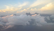
Hawaii is the largest island in the United States, located in the state of Hawaii. It is the southeasternmost of the Hawaiian Islands, a chain of volcanic islands in the North Pacific Ocean. With an area of 4,028 square miles (10,430 km2), it has 63% of the Hawaiian archipelago's combined landmass. However, it has only 13% of Hawaiʻi's population. The island of Hawaiʻi is the third largest island in Polynesia, behind the two main islands of New Zealand.

Mauna Loa Volcano in Hawaii, United States

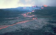
Mauna Loa is one of five volcanoes that form the Island of Hawaii in the U.S. state of Hawaiʻi in the Pacific Ocean. The largest subaerial volcano in both mass and volume, Mauna Loa has historically been considered the largest volcano on Earth, dwarfed only by Tamu Massif. It is an active shield volcano with relatively gentle slopes, with a volume estimated at 18,000 cubic miles (75,000 km3), although its peak is about 125 feet (38 m) lower than that of its neighbor, Mauna Kea. Lava eruptions from Mauna Loa are silica-poor and very fluid, and they tend to be non-explosive.

Mauna Kea Hawaiian volcano

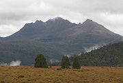
Mauna Kea is a dormant volcano on the island of Hawaiʻi. Its peak is 4,207.3 m (13,803 ft) above sea level, making it the highest point in the state of Hawaiʻi and second-highest peak of an island on Earth. The peak is about 38 m (125 ft) higher than Mauna Loa, its more massive neighbor. Mauna Kea is unusually topographically prominent for its height: its wet prominence is fifteenth in the world among mountains, at 4,207.3 m (13,803 ft); its dry prominence of 9,330 m (30,610 ft) is second in the world, only after Mount Everest. This dry prominence is taller than Mount Everest's height above sea level of 8,848.86 m (29,032 ft), and some authorities have labelled Mauna Kea the tallest mountain in the world, from its underwater base.

Haleakalā Massive shield volcano in Hawaii

Haleakalā, or the East Maui Volcano, is a massive shield volcano that forms more than 75% of the Hawaiian Island of Maui. The western 25% of the island is formed by another volcano, Mauna Kahalawai, also referred to as the West Maui Mountains.

Volcanic Seven Summits Highest volcanoes of the seven continents

The Volcanic Seven Summits are the highest volcanoes on each of the seven continents, just as the Seven Summits are the highest peaks on each of the seven continents. Summiting all seven is regarded as a mountaineering challenge, first postulated as such in 1999.

Topographic isolation Topography measuring minimum distance to a point of equal elevation

The topographic isolation of a summit is the minimum distance to a point of equal elevation, representing a radius of dominance in which the peak is the highest point. It can be calculated for small hills and islands as well as for major mountain peaks and can even be calculated for submarine summits.

References

  1. The source used for Finesterre High Point notes that recent SRTM data suggests an elevation closer to (but at least) 4,120 m. This would support Peakbagger which lists the peak at 4,125 m.
  2. "SUMMIT". Datasheet for NGS Station TU2314. U.S. National Geodetic Survey . Retrieved March 20, 2016.
  3. "Mauna Kea". Peakbagger.com. Retrieved March 20, 2016.
  4. "Mauna Kea". Bivouac.com. Retrieved March 20, 2016.
  5. "Haleakalā". Peakbagger.com. Retrieved March 20, 2016.
  6. "Haleakalā". Bivouac.com. Retrieved March 20, 2016.
  7. "Mauna Loa". Peakbagger.com. Retrieved March 20, 2016.
  8. "Mauna Loa". Bivouac.com. Retrieved March 20, 2016.
  9. "Puʻu Kukui". Peakbagger.com. Retrieved March 20, 2016.
  10. "Puʻu Kukui". Bivouac.com. Retrieved March 20, 2016.
  11. "Kawaikini". Peakbagger.com. Retrieved March 20, 2016.
  12. "Kawaikini". Bivouac.com. Retrieved March 20, 2016.
  13. "Kamakou". Peakbagger.com. Retrieved March 20, 2016.
  14. "Kamakou". Bivouac.com. Retrieved March 20, 2016.

Sources